


Get to know Leishan County
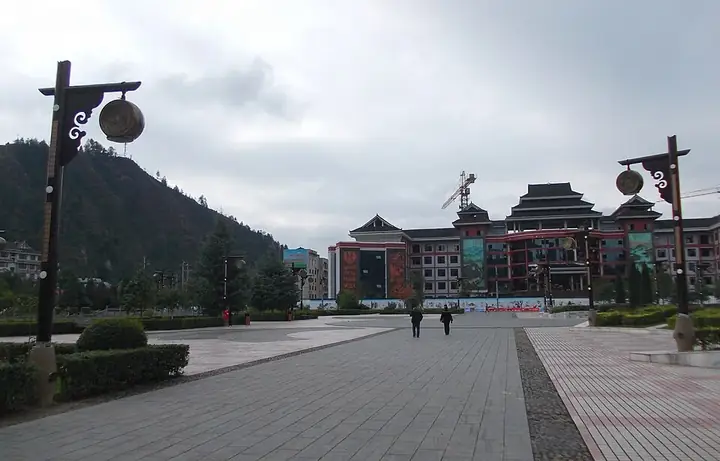
Photo adjustments
Full frame retained; resized proportionally to a maximum dimension of 960 pixels and converted to WebP quality 88. No crop, retouch, generated elements, or subject alteration. Final website rendition: full frame retained, proportionally resized to at most 720 pixels and converted to WebP. No additional retouching or subject alteration. Card displays may crop the view.
- Administrative area
- County · 县
- Part of
- Qiandongnan Miao and Dong Autonomous Prefecture
- Chinese name
- 雷山县
- Local areas
- County guide
Area & population
- Area in the source
- 1,218.50 km²
- Population · 2010
- 117,198
- Administrative seat
- Danjiang
Source: cited geographic source, as of the dates shown.
Setting and landscape
Leishan borders Taijiang (台江), Jianhe (剑河) and Rongjiang (榕江) to the east, Sandu Shui Autonomous County (三都水族自治县) to the south, Danzhai (丹寨县) to the west and Kaili to the north. It sits on the slope where the Yunnan–Guizhou Plateau falls towards the hill basins of Hunan and Guangxi, high in the north-east and low in the south-west, with its lowest point at 480 metres. The Leigong range, crossing the county from north-east to south-west, divides the Qingshui River (清水江) from the Duliu River (都柳江): about 63 per cent of the county drains to the Yuan River system of the Yangtze and the rest to the Liu River system of the Pearl. The county government describes it as a typical county of "nine parts mountain, half water, half field".
Leigong Mountain became a national nature reserve in 2001 and a national forest park in 2002.
History
The Qing set up Danjiang subprefecture (丹江厅) at old Danjiang (老丹江) in 1729, under Duyun prefecture (都匀府), and moved its seat in 1872 to Zhaoqingbao (肇庆堡), today's county town. It became Danjiang County in 1913 and was abolished in 1941, its land going to Taigong (台拱) and Bazhai (八寨) counties. The Leishan administrative bureau (雷山设治局) was set up in 1944 and became Leishan County in 1950.
What to see
The county has more than 350 Miao villages, 68 national traditional villages and 15 items on the national intangible heritage list; the county government says no county in China has more national intangible heritage items or a denser cluster of traditional villages. Xijiang Qianhu Miao Village (西江千户苗寨) and Langde Miao Village (郎德苗寨) are national 4A scenic areas. Xijiang was named a Chinese historic and cultural town in 2007, and the old buildings of Langde Upper Village (郎德上寨) became a national key protected site in 2001.
Paika (排卡苗寨), a Miao village three kilometres from the county town, is known for making the lusheng (芦笙) reed pipe, a craft said to go back more than 400 years there. Leishan was also named China's home of Miao silver ornaments in 2008.
Food and local products
Leishan grows teas such as Yinqiu (银球茶) and Qingming tea (清明茶); Yinqiu has been named one of Guizhou's ten famous teas. Bamboo shoots, konjac and ferns from the county's hills are sold as far as Hong Kong, Macau, Taiwan and Japan.
Highlights
- Xijiang Qianhu Miao Village 西江千户苗寨: National 4A scenic area; Xijiang named a Chinese historic and cultural town in 2007.
- Langde Miao Village 郎德苗寨: National 4A scenic area; Langde Upper Village's old buildings are a national key protected site (2001).
- Leigong Mountain 雷公山: Highest point at 2,178.8 metres; national nature reserve since 2001.
- Paika Miao Village 排卡苗寨: Lusheng-making village three kilometres from the county town.
- Yinqiu tea 银球茶: Named one of Guizhou's ten famous teas.
Sources for this guide
雷山县人民政府网-雷山简介 · Leishan County People's Government
自然地理 · Leishan County People's Government
历史沿革 · Leishan County People's Government
排卡苗寨 - 芦笙制作之乡 · Leishan County People's Government
Original English written from the listed sources and checked sentence by sentence against quoted extracts by a separate reviewer. Updated 2026-09-25.
Explore Leishan County
Core places to explore, with English and Chinese names.
Places to explore around Leishan County
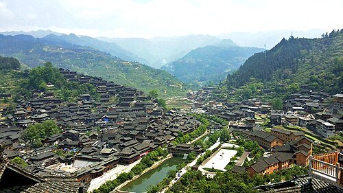 Xijiang Miao Nationality Village · 西江千户苗寨
Xijiang, Guizhou西江千户苗寨
Xijiang’s dark timber houses climb two adjacent hillsides above a river, creating a dense layered roofscape. The riverfront and main street are developed visitor areas, while the hillside lanes also contain residents’ homes…
Read the place guide → Langde Miao Village · 郎德苗寨
Langde Miao Village郎德苗寨
Langde’s upper village is a compact settlement of stone-paved lanes and houses above a tributary of the Bala River. The main square provides a natural focal point, while the edge of the village opens towards rice fields and the…
Read the place guide → Leigong Mountain Official Visitor Area · 雷公山正规开放游览区
Leigong Mountain Official Visitor Area雷公山正规开放游览区
Leigongshan is the summit of the Miaoling range in Leishan County, Qiandongnan, Guizhou, with a main peak at 2,178.8 metres, 30 kilometres north-east of the county town. It is historically known as Niupi Dajing and is called Fangbiele in the Miao language, meaning 'the place where the thunder god lives'; the mountain holds a national-level nature reserve, a national geopark and a national forest park designation.
Read the place guide →Local life & food
Leishan County local specialties
雷山县特色美食 · 1 specialties to discover
 Leishan chicken rice porridge 雷山鸡稀饭AI dish illustration / AI 菜品示意图
The porridge is soft and savoury with a chicken flavour that runs through the grains. It is a meal rather than a sweet rice drink.
Source ↗Read the dish guide →All dish names · 全部菜名 (1)
More dishes from across Guizhou are in the Guizhou food guide.
Plan your visit
Getting there
Leishan County is about 25 km in a straight line from central Qiandongnan Miao and Dong Autonomous Prefecture. Search for 雷山县 in a map app to find stations and your accommodation.
Where to stay →Build your route
Xijiang, Guizhou and Langde Miao Village are about 10 km apart in a straight line. The linked place guides have entrance and visit details.
Continue with Qiandongnan Miao and Dong Autonomous Prefecture →More in Qiandongnan Miao and Dong Autonomous Prefecture
Sources & geographic information
Administrative names and parent areas: Official geographic directory · Reference date 2026-09-06.
Photo: Xijiang, Guizhou · Popolon · CC BY-SA 4.0. Wikimedia thumbnail; fitted to the ranking-card frame.

Photo: Langde Miao Village · Source photographer · License not provided. EXIF orientation normalized; resized without changing aspect ratio; converted to WebP. No subject edits.
Photo: Leigong Mountain Official Visitor Area · Source photographer · License not provided. EXIF orientation normalized; resized without changing aspect ratio; converted to WebP. No subject edits.
Map data © OpenStreetMap contributors. Pins mark approximate centres, not entrances or boundaries.