


Get to know Fujin

- Administrative area
- County-level city · 县级市
- Part of
- Jiamusi
- Chinese name
- 富锦市
- Local areas
- County-level city guide
Area & population
- Area in the source
- 8,227.00 km²
- Population · 2019
- 452,379
Source: cited geographic source, as of the dates shown.
Setting and landscape
Most of Fujin is a low, flat alluvial plain averaging about 60 metres above sea level, slightly higher in the south-west. Outliers of the Wanda Mountains (完达山) reach into it: Bielayinzi Mountain (别拉音子山), 472.8 metres, rises 30 kilometres west of the city, and Wurguli Mountain (乌尔古力山), 538.7 metres, 11 kilometres east of it. The Songhua passes through for 84 kilometres, with Fujin facing Suibin County (绥滨县) across the water, and the Naoli River (挠力河) and the Qixing River (七星河) cross its territory. Neighbours include Huachuan (桦川县) and Jixian (集贤县) to the west and Tongjiang (同江市) and Raohe (饶河县) to the east.
The climate is continental monsoon: January averages -18.6°C and July 22.3°C. The ground usually freezes in late October and does not fully thaw until late May or early June. Black soil and meadow soil are the main soil types.
History
In 1409 the Ming court set up the Futi garrison (弗提卫) here under the Nurgan command, with its post at what is now the Datun old city (大屯古城). In 1882 the Qing created the Fukejin (富克锦) military office after Hezhe (赫哲) soldiers won distinction in Gansu, and in 1909 the Fukejin inspectorate was raised to Fujin County. Japanese troops occupied Fujin in June 1932; the Soviet Red Army and the Northeast Anti-Japanese United Army took it on 12 August 1945. The State Council made Fujin a county-level city on 30 August 1988.
What to see
Fujin National Wetland Park (富锦国家湿地公园) covers 2,200 hectares of marsh about 50 kilometres south-west of the city. It became a national wetland park in 2009 and a national AAAA-rated scenic area in 2013. More than 290 wild plant species grow there, including reeds, water lilies, cattails and bulrushes, and Heilongjiang Daily counts more than 170 bird species, among them red-crowned and white-naped cranes, spoonbills and great egrets. Visitors follow boardwalks over the water, climb the bird-watching tower or use viewing platforms, and boats carry visitors into the marsh.
Highlights
- Fujin National Wetland Park 富锦国家湿地公园: 2,200-hectare marsh 50 km south-west of the city, a national wetland park since 2009, with a bird-watching tower and boardwalks.
- Wurguli Mountain 乌尔古力山: 538.7-metre outlier of the Wanda Mountains, 11 km east of the city.
- Datun old city 大屯古城: Site of the Ming Futi garrison, founded in 1409.
Sources for this guide
历史沿革 · Fujin City People's Government (Fujin Archives)
自然地理 · Fujin City People's Government
环境条件 · Fujin City People's Government
黑龙江富锦:初秋时节湿地公园人气旺 · Heilongjiang Provincial People's Government
富锦国家湿地公园——魅力富锦的金名片 · Heilongjiang Daily (hljnews.cn)
Original English written from the listed sources and checked sentence by sentence against quoted extracts by a separate reviewer. Updated 2026-09-24.
Explore Fujin
Core places to explore, with English and Chinese names.
Places to explore around Fujin
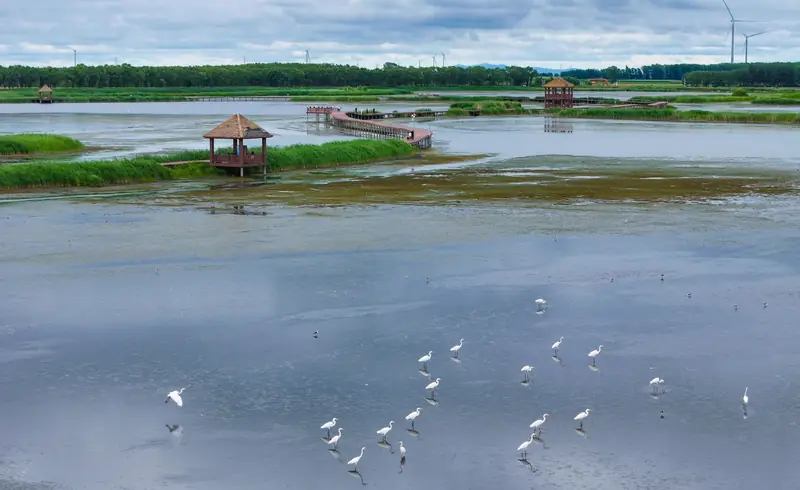 Fujin National Wetland Park ·
 Plan your visit
Getting there
Fujin is about 140 km in a straight line from central Jiamusi. Search for 富锦市 in a map app to find stations and your accommodation.
Where to stay →Build your route
Start with Fujin National Wetland Park. The linked place guides have entrance and visit details.
Continue with Jiamusi →More in Jiamusi
Sources & geographic information
Administrative names and parent areas: Official geographic directory · Reference date 2026-09-06.
Photo: Fujin National Wetland Park · Source photographer · License not provided. EXIF orientation normalized; resized without changing aspect ratio; converted to WebP. No subject edits.
Map data © OpenStreetMap contributors. Pins mark approximate centres, not entrances or boundaries.