


Get to know Xinning County
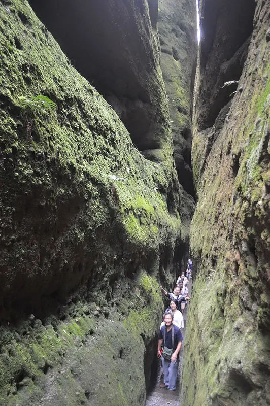
Photo adjustments
Full frame retained; proportionally resized and converted to WebP. No retouching or changes to the photographed subject. Card displays may crop the view.
- Administrative area
- County · 县
- Part of
- Shaoyang
- Chinese name
- 新宁县
- Local areas
- County guide
Setting and landscape
The county government describes Xinning as mountain country in the Wuling (五岭) region, screened to the south-east by the Yuecheng Mountains (越城岭) and backed to the south-west by outliers of the Xuefeng range, so that the land slopes down from south-east to north-west. The Fuyi River rises in Ziyuan (资源) county in Guangxi and runs north-east through the county for 114.5 km; small valley plains are strung along it, and the north-west and north-east are karst hills.
Several of its mountains are provincial nature reserves. Shunhuang Mountain (舜皇山), on the boundary with Dong'an (东安), rises to 1,882.4 metres at Longbikong (龙鼻孔) and takes its name from a summit rock carved "Shun Peak Summit"; a temple to the sage-king Shun stands at its foot. Ziyun Mountain (紫云山), in the east of the county, and Wanfeng Mountain (万峰山) are also provincial reserves.
What to see
Langshan covers 108 square kilometres and is divided into six scenic areas: Bajiaozhai (八角寨), Lajiao Peak (辣椒峰), Tianyi Lane (天一巷), the Fuyi River, Zixia Cave (紫霞峒) and the Tiansheng natural bridge (天生桥). In 2010 it was inscribed on the World Heritage list with five other Danxia areas as "China Danxia" (中国丹霞); it is also a national geopark and a national 5A scenic area. Its landforms include flat-topped rock platforms, free-standing stone pillars and walls, sheer red cliffs and narrow winding rock lanes.
Bajiaozhai, also called Yuntai Mountain (云台山), is a peak of 816.6 metres named for its eight exposed ridges. Cliffs surround it on three sides, a narrow stone ridge path leads to the summit, and the Ming-period Yuntai Temple on top was burned by Japanese troops in early 1945.
History and customs
A Fuyi marquisate (夫彝侯国) was set up here in 124 BC, and the county was renamed several times, becoming Fu county in 402 and Fuyang under the Liang. The Southern Song created Xinning county in 1155; the name, "new peace", marked the end of an uprising led by Yang Zaixing (杨再兴). The county government records a strong Yao singing tradition, in which guests entering a home sing a song of praise and the hosts answer with a song of thanks.
Food and local products
Langshan navel oranges (崀山脐橙) are a national geographical-indication product. Langshan cured pork (崀山腊肉) is made from the legs of farm-raised pigs, salted with Sichuan pepper and strong liquor, then smoked over sawdust or, preferably, a wood fire; the lean turns dark red and the fat pale and translucent.
Highlights
- Langshan 崀山: Danxia landform area inscribed in 2010 as part of the China Danxia World Heritage site.
- Bajiaozhai 八角寨: 816.6-metre peak with cliffs on three sides and a ridge path to the summit.
- Shunhuang Mountain 舜皇山: Provincial nature reserve rising to 1,882.4 metres, with a temple to Shun at its foot.
- Langshan navel oranges 崀山脐橙: National geographical-indication product.
- Langshan cured pork 崀山腊肉: Salted pork legs smoked over a wood fire.
Sources for this guide
崀山 - 维基百科,自由的百科全书 · Chinese Wikipedia · CC BY-SA 4.0
新宁概况-新宁县人民政府 · Xinning County People's Government
自然地理-新宁县人民政府 · Xinning County People's Government
历史文化-新宁县人民政府 · Xinning County People's Government
风土人情-新宁县人民政府 · Xinning County People's Government
崀山脐橙-新宁县人民政府 · Xinning County People's Government
柴火腊肉-新宁县人民政府 · Xinning County People's Government
Original English written from the listed sources and checked sentence by sentence against quoted extracts by a separate reviewer. Updated 2026-09-24.
Explore Xinning County
Core places to explore, with English and Chinese names.
Places to explore around Xinning County
Plan your visit
Getting there
Xinning County is about 110 km in a straight line from central Shaoyang. Search for 新宁县 in a map app to find stations and your accommodation.
Where to stay →Build your route
Start with Langshan. The linked place guides have entrance and visit details.
Continue with Shaoyang →More in Shaoyang
Sources & geographic information
Administrative names and parent areas: Official geographic directory · Reference date 2026-09-06.
Some facts checked against 崀山 — Wikipedia contributors, CC BY-SA 4.0.
Photo: Langshan · Huangdan2060 · CC BY 3.0. Full frame retained; proportionally resized and converted to WebP. No retouching or changes to the photographed subject. Card displays may crop the view.

Map data © OpenStreetMap contributors. Pins mark approximate centres, not entrances or boundaries.