


Get to know Guzhang County
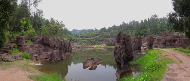
Photo adjustments
Full frame retained; proportionally resized and converted to WebP. No retouching or changes to the photographed subject. Card displays may crop the view.
- Administrative area
- County · 县
- Part of
- Xiangxi Tujia and Miao Autonomous Prefecture
- Chinese name
- 古丈县
- Local areas
- County guide
Area & population
- Area in the source
- 1,286.23 km²
- Population · 2010
- 144,800
Source: cited geographic source, as of the dates shown.
Setting and landscape
The Wuling range runs diagonally across the county, whose elevation ranges from 147 metres to 1,146 metres. Neighbours are Yongshun (永顺) to the north, Yuanling (沅陵) to the east, Luxi (泸溪) and Jishou (吉首) to the south and Huayuan (花垣) to the west. The Gaowangjie National Nature Reserve (高望界国家级自然保护区) covers 17,169.8 hectares with 93.7 percent forest cover and preserves an intact subtropical evergreen broadleaf forest ecosystem; the silver pheasant and the Gaowangjie warty newt have been recorded there.
History
In 940 the Chu kingdom of the Ma family moved the seat of Xizhou (溪州) to Huixiping, today's Guyang town (古阳镇), and in 1075 the Northern Song built Huixi City there. Under the Ming the land belonged to the Yongshun native pacification commission. In 1822 the Qing carved Guzhangping Subprefecture (古丈坪厅) out of Yongshun County, named after the Guzhangping flat where it had its seat, and in 1913 it became Guzhang County.
What to see
The Red Stone Forest National Geopark (红石林国家地质公园) in Hongshilin town (红石林镇) is a rare forest of red carbonate rock pillars formed in the Ordovician; their colour changes with the season and the weather. It lies 15 kilometres from Qifeng Lake (栖凤湖), where former fishermen now run farm stays and work in tourism. Miao villages open to visitors include Morong (墨戎苗寨) and Hangwu (夯吾苗寨), and Zuolongxia (坐龙峡), Shutouxi (梳头溪) and Yanpaixi (岩排溪) are rural tourism villages. Laosiyan (老司岩村) in Hongshilin town was listed in 2012 among the first Chinese traditional villages. The county's festivals include the Tujia Sheba day (舍巴日) and the Miao Tiaoxiang festival (跳香节).
Food and local products
Guzhang maojian (古丈毛尖) green tea has been a tribute tea since the Tang dynasty. Tea gardens cover 205,000 mu across the county, and tea is grown in nine out of ten of its villages; a tea-and-tourism belt follows the G352 highway.
Highlights
- Red Stone Forest National Geopark 红石林国家地质公园: Ordovician red carbonate rock pillars whose colour shifts with season and weather.
- Gaowangjie National Nature Reserve 高望界国家级自然保护区: A 17,169.8-hectare reserve with an intact subtropical evergreen broadleaf forest ecosystem.
- Morong Miao village 墨戎苗寨: One of the Miao villages that draws visitors to the county.
- Guzhang maojian 古丈毛尖: Green tea sent as tribute since the Tang dynasty.
Sources for this guide
古丈县 - 维基百科,自由的百科全书 · Chinese Wikipedia · CC BY-SA 4.0
红石林国家地质公园 - 维基百科,自由的百科全书 · Chinese Wikipedia · CC BY-SA 4.0
红石林镇 - 维基百科,自由的百科全书 · Chinese Wikipedia · CC BY-SA 4.0
绿色茶乡绘新卷——古丈县“十四五”经济社会发展走笔 · Hunan Daily, republished by the Policy Research Office of the CPC Hunan Provincial Committee (hnzy.gov.cn)
Original English written from the listed sources and checked sentence by sentence against quoted extracts by a separate reviewer. Updated 2026-09-25.
Explore Guzhang County
Core places to explore, with English and Chinese names.
Places to explore around Guzhang County
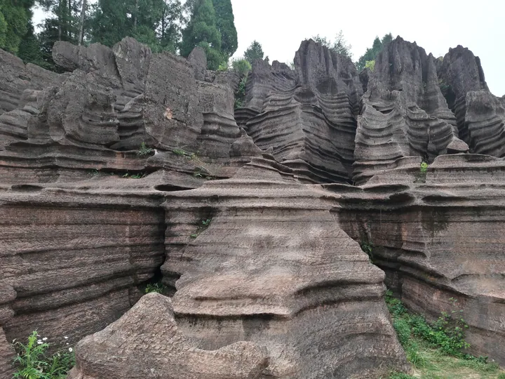 The red sandstone formations of Hongshilin (Red Stone Forest) in Guzhang County · 古丈县红石林 Source-recorded photograph date: 2017-05-30 14:23:38.
Red Stone Forest红石林
Hongshilin (红石林) is a stone forest of red carbonate rock in Guzhang county, in the Xiangxi Tujia and Miao Autonomous Prefecture of Hunan. It is a national geopark and forms one of the seven parks of the Xiangxi UNESCO Global Geopark.
Read the place guide →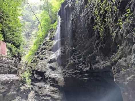 Zuolong Gorge · 坐龙峡
Zuolong Gorge坐龙峡
Zuolongxia (坐龙峡) is a narrow gorge in Guzhang county, in the Xiangxi Tujia and Miao Autonomous Prefecture of Hunan, facing Furong Town across the You river. It is the central feature of Zuolongxia National Forest Park, which the national forestry authority approved in January 2012.
Read the place guide →Plan your visit
Getting there
Guzhang County is about 40 km in a straight line from central Xiangxi Tujia and Miao Autonomous Prefecture. Search for 古丈县 in a map app to find stations and your accommodation.
Where to stay →Build your route
Red Stone Forest and Zuolong Gorge are both listed here. The linked place guides have entrance and visit details.
Continue with Xiangxi Tujia and Miao Autonomous Prefecture →More in Xiangxi Tujia and Miao Autonomous Prefecture
Sources & geographic information
Administrative names and parent areas: Official geographic directory · Reference date 2026-09-06.
Some facts checked against 古丈县 — Wikipedia contributors, CC BY-SA 4.0.
Some facts checked against 红石林国家地质公园 — Wikipedia contributors, CC BY-SA 4.0.
Some facts checked against 红石林镇 — Wikipedia contributors, CC BY-SA 4.0.
Photo: Red Stone Forest · Popolon · CC BY-SA 4.0. Full frame retained; proportionally resized and converted to WebP. No retouching or changes to the photographed subject. Card displays may crop the view.

Photo: Zuolong Gorge · Source photographer · License not provided. EXIF orientation normalized; resized without changing aspect ratio; converted to WebP. No subject edits.
Map data © OpenStreetMap contributors. Pins mark approximate centres, not entrances or boundaries.