


Get to know Yongshun County
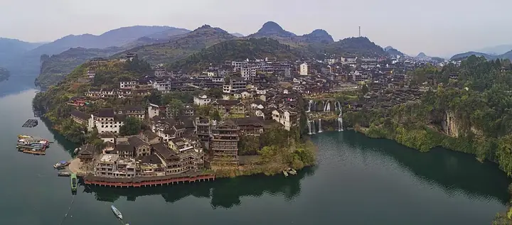
Photo adjustments
Full frame retained; resized proportionally to a maximum dimension of 960 pixels and converted to WebP quality 88. No crop, retouch, generated elements, or subject alteration. Final website rendition: full frame retained, proportionally resized to at most 720 pixels and converted to WebP. No additional retouching or subject alteration. Card displays may crop the view.
- Administrative area
- County · 县
- Part of
- Xiangxi Tujia and Miao Autonomous Prefecture
- Chinese name
- 永顺县
- Local areas
- County guide
Area & population
- Area in the source
- 3,809.69 km²
- Population · 2010
- 428,373
Source: cited geographic source, as of the dates shown.
Setting and landscape
The main heights are Yangfeng Mountain (羊峰山), whose summit is the county's high point at 1,438 m, Daqing Mountain (大青山) and Rentou Mountain (人头山); the lowest point, 119 m, is on the Youshui, which forms part of the Fengtan Reservoir (凤滩水库) in the south. The Mengdong River runs through the county from north to south. The Xiaoxi National Nature Reserve (小溪国家自然保护区) keeps a secondary forest that Hunan Daily says escaped Quaternary glaciation, with dove trees (珙桐), nanmu and dawn redwood among more than 20 protected tree species.
History
The area was Xizhou (溪州) under the Tang and Yongshun Prefecture under the Song, and the Yuan and Ming ran it through native pacification offices. According to the Qing Yongshun county gazetteer, the chieftain Peng Fushichong (彭福石宠) moved his seat to Laosicheng (老司城) on the Lingxi River in 1135. Direct imperial rule replaced the chieftaincy in 1728, the last chieftain left for his ancestral home in Jiangxi the next year, and the town was abandoned; Yongshun County was created in 1729.
What to see
The Laosicheng Site (老司城遗址) in Lingxi town (灵溪镇) was listed nationally in 2001 and inscribed in 2015 as one of the Tusi Sites on the World Heritage list. Four rounds of survey and excavation between 1995 and 2011 mapped a palace and office quarter at its centre, surrounded by streets, chieftains' tombs and religious areas; most buildings date from the Ming.
Furong Town (芙蓉镇), formerly Wangcun (王村), was a chieftain's secondary residence and took its present name after the film Hibiscus Town was shot there. It sits above a waterfall, and in the Ming and Qing its river trade earned it the nickname "Little Nanjing". Rafting on the Mengdong River covers 17 km of rapids and slack water between forested cliffs; in 1991 the sociologist Fei Xiaotong (费孝通) called it the finest rafting in China. Buermen National Forest Park (不二门), on the Mengdong south of the county town, has a hot spring, cave, cliff inscriptions and sites from the Shang to the Warring States. Shuangfeng village (双凤村), listed as a Chinese Historical and Cultural Village in 2019, has national intangible-heritage items including the Maogusi (毛古斯) dance, the hand-waving dance and Tujia brocade weaving.
Food and local products
Xizhou vine tea (溪州莓茶), a Chinese geographical-indication product, is made from the stems of Ampelopsis grossedentata (显齿蛇葡萄), a wild vine of the county's hills.
Highlights
- Laosicheng Site 老司城遗址: Seat of the Peng chieftains from 1135, inscribed as a Tusi Site on the World Heritage list in 2015.
- Furong Town 芙蓉镇: Old river town above a waterfall, renamed after the film Hibiscus Town.
- Mengdong River rafting 猛洞河漂流: A 17 km run of rapids and slack water between forested cliffs.
- Shuangfeng village 双凤村: Tujia village listed as a Chinese Historical and Cultural Village in 2019.
- Xizhou vine tea 溪州莓茶: Geographical-indication drink made from the stems of a wild vine.
Sources for this guide
永顺县 - 维基百科,自由的百科全书 · Wikipedia (Chinese) · CC BY-SA 4.0
梦幻芙蓉 诗意溪洲——永顺县生态文化旅游发展走笔_湖南探索_湖南政研网 · Hunan Daily, republished by the Policy Research Office of the CPC Hunan Provincial Committee (hnzy.gov.cn)
老司城遗址 - 维基百科,自由的百科全书 · Wikipedia (Chinese) · CC BY-SA 4.0
Original English written from the listed sources and checked sentence by sentence against quoted extracts by a separate reviewer. Updated 2026-09-25.
Explore Yongshun County
Core places to explore, with English and Chinese names.
Places to explore around Yongshun County
 AI illustration · AI 示意图(仅供参考,非该地点实拍)
Laosicheng Site老司城遗址
Ruined capital of the Peng chieftains of Yongshun on the Lingxi River, excavated since 1995 and inscribed on the World Heritage List in 2015.
Read the place guide →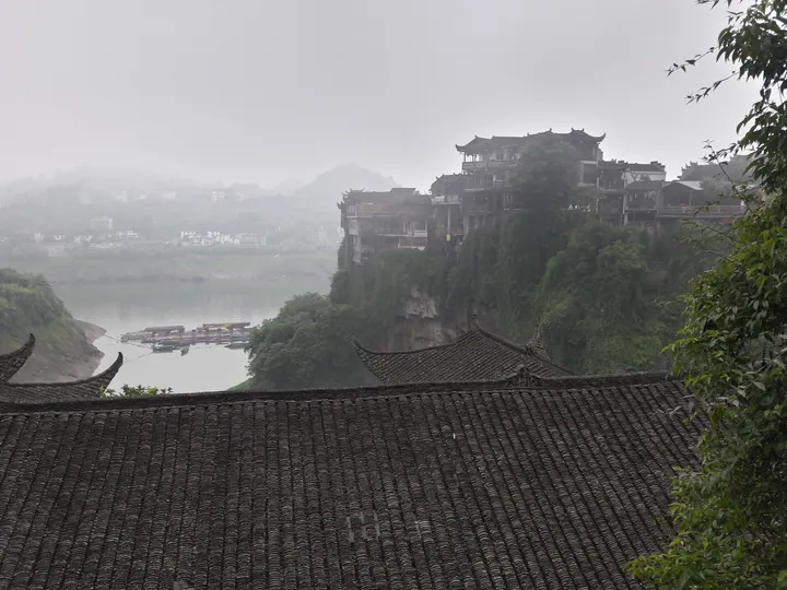 Stilted buildings of Furong Town perched above the river, Yongshun County, Xiangxi · 湘西土家族苗族自治州永顺县芙蓉镇,吊脚楼与河流 Source-recorded photograph date: 2017-05-31 07:03:54.
Furong Town芙蓉镇
Furong Town (芙蓉镇) stands on the north bank of the You river in Yongshun county, in the Xiangxi Tujia and Miao Autonomous Prefecture of Hunan. Water surrounds it on three sides and a stream falls through the settlement itself, which is why it is known as the old town hanging on a waterfall.
Read the place guide →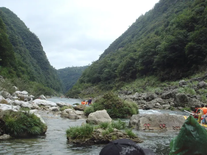 Rafters on the Mengdong River in its forested gorge, Yongshun County, Xiangxi · 湘西永顺县猛洞河漂流,峡谷中的漂流游客 Source-recorded photograph date: Taken on 30 August 2009.
Mengdong River Rafting猛洞河漂流
Mengdonghe rafting (猛洞河漂流) follows the Si river, a tributary of the Mengdong river, in Yongshun county in the Xiangxi Tujia and Miao Autonomous Prefecture of Hunan. The run begins at Hanigong, a little over ten kilometres from Furong Town.
Read the place guide →Plan your visit
Getting there
Yongshun County is about 80 km in a straight line from central Xiangxi Tujia and Miao Autonomous Prefecture. Search for 永顺县 in a map app to find stations and your accommodation.
Where to stay →Build your route
Laosicheng Site and Furong Town are both listed here. The linked place guides have entrance and visit details.
Continue with Xiangxi Tujia and Miao Autonomous Prefecture →More in Xiangxi Tujia and Miao Autonomous Prefecture
Sources & geographic information
Administrative names and parent areas: Official geographic directory · Reference date 2026-09-06.
Some facts checked against 永顺县 — Wikipedia contributors, CC BY-SA 4.0.
Some facts checked against 老司城遗址 — Wikipedia contributors, CC BY-SA 4.0.
Photo: Furong Town · Popolon · CC BY-SA 4.0. Full frame retained; proportionally resized and converted to WebP. No retouching or changes to the photographed subject. Card displays may crop the view.

Photo: Mengdong River Rafting · john2636(強) · CC BY-SA 3.0. Full frame retained; proportionally resized and converted to WebP. No retouching or changes to the photographed subject. Card displays may crop the view.
.jpg)
Map data © OpenStreetMap contributors. Pins mark approximate centres, not entrances or boundaries.