


Get to know Xiangxi Tujia and Miao Autonomous Prefecture
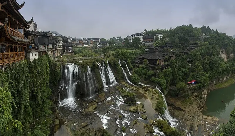
Photo adjustments
Full frame retained; proportionally resized and converted to WebP. No retouching or changes to the photographed subject. Card displays may crop the view.
- Administrative area
- Autonomous prefecture · 自治州
- Part of
- Hunan
- Chinese name
- 湘西土家族苗族自治州
- Local areas
- 8 local areas
Area & population
- Area in the source
- 15,486.00 km²
- Population · 2022
- 2,902,000
- Administrative seat
- Jishou
Source: cited geographic source, as of the dates shown.
Explore Xiangxi Tujia and Miao Autonomous Prefecture
Core places to explore, with English and Chinese names.
Fenghuang Ancient Town 凤凰古城
Laosicheng 老司城
Aizhai Bridge 矮寨大桥
Dehang Grand Canyon 德夯大峡谷
Shibadong Village 十八洞村
Ludong Mountain 吕洞山
Red Stone Forest 红石林
Zuolong Gorge 坐龙峡
Dehang Miao Village and Canyon 德夯苗寨与峡谷
Aizhai Bridge Viewing Area 矮寨大桥观景区
Qianzhou Ancient City 乾州古城
Laosicheng Site 老司城遗址
Furong Town 芙蓉镇
Mengdong River Rafting 猛洞河漂流
Pushi Ancient Town 浦市古镇
Chadong Border Town 边城茶峒
Bamian Mountain 八面山
Liye Ancient City and Qin Bamboo Slips Museum 里耶古城与秦简博物馆
Rebala Tujia Villages 惹巴拉
Jishou 吉首市
Luxi County 泸溪县
Fenghuang County 凤凰县
Huayuan County 花垣县
Baojing County 保靖县
Guzhang County 古丈县
Yongshun County 永顺县
Longshan County 龙山县
Places to explore around Xiangxi Tujia and Miao Autonomous Prefecture
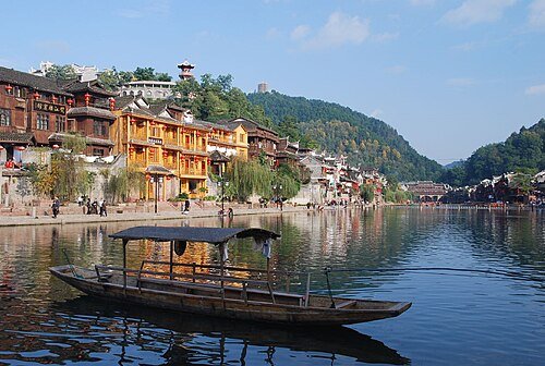 Phoenix Ancient Town · 凤凰古城
Fenghuang Ancient Town凤凰古城
Fenghuang’s old town follows the Tuo River, where stilted riverside buildings, bridges and lanes create its familiar silhouette. The former home of writer Shen Congwen offers a more focused cultural visit within the busy…
Read the place guide →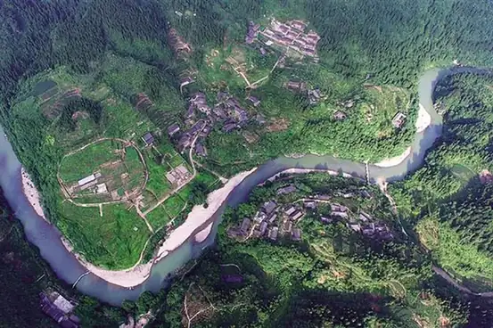 Laosicheng · 老司城
Laosicheng老司城
Laosicheng preserves the archaeological landscape of the Peng hereditary rulers beside the Lingxi River. The remains of administrative and residential areas, streets and drainage reveal how a Tusi capital functioned, while…
Read the place guide → Aizhai Bridge suspended across the valley near Jishou, September 2025.
Aizhai Bridge矮寨大桥
Aizhai Bridge carries an expressway across the deep valley near Jishou, with the span running between mountain tunnels. The scenic visitor experience is separate from driving across the motorway: designated bridge viewing and…
Read the place guide →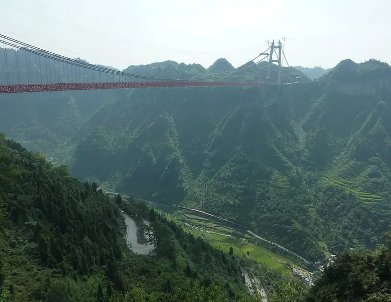 Dehang Grand Canyon (德夯大峡谷), Jishou. Photograph: "Aizhai Bridge-8".
Dehang Grand Canyon德夯大峡谷
Dehang Grand Canyon near Jishou combines the Xiangxi geological landscape with a Miao village setting and cultural traditions.
Read the place guide → AI illustration · AI 示意图(仅供参考,非该地点实拍)
Shibadong Village十八洞村
Shibadong is a Miao village in Huayuan County, known for its place in China's targeted poverty-alleviation programme.
Read the place guide → Ludong Mountain · 吕洞山
Ludong Mountain吕洞山
Ludongshan (吕洞山) rises in Ludongshan town, Baojing county, in the Xiangxi Tujia and Miao Autonomous Prefecture of Hunan, and is the main peak of the range that carries its name. It is revered by the Miao as their ancestral sacred mountain and forms one of the seven parks of the Xiangxi UNESCO Global Geopark.
Read the place guide →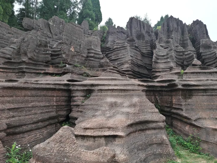 The red sandstone formations of Hongshilin (Red Stone Forest) in Guzhang County · 古丈县红石林 Source-recorded photograph date: 2017-05-30 14:23:38.
Red Stone Forest红石林
Hongshilin (红石林) is a stone forest of red carbonate rock in Guzhang county, in the Xiangxi Tujia and Miao Autonomous Prefecture of Hunan. It is a national geopark and forms one of the seven parks of the Xiangxi UNESCO Global Geopark.
Read the place guide →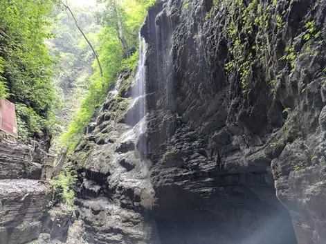 Zuolong Gorge · 坐龙峡
Zuolong Gorge坐龙峡
Zuolongxia (坐龙峡) is a narrow gorge in Guzhang county, in the Xiangxi Tujia and Miao Autonomous Prefecture of Hunan, facing Furong Town across the You river. It is the central feature of Zuolongxia National Forest Park, which the national forestry authority approved in January 2012.
Read the place guide →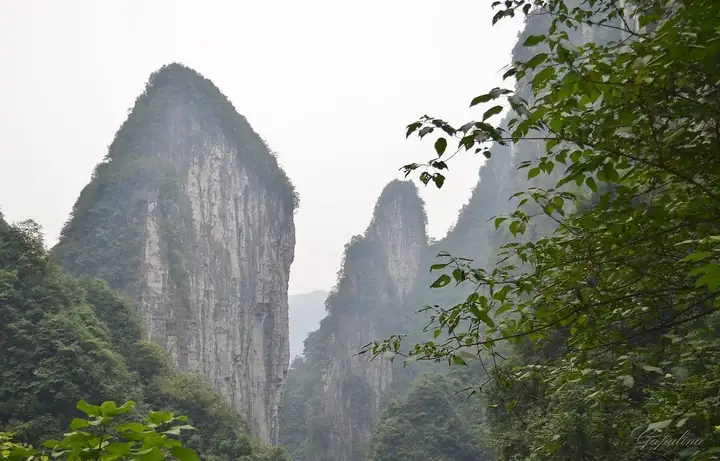 Dehang Miao Village and Canyon · 德夯苗寨与峡谷
Dehang Miao Village and Canyon德夯苗寨与峡谷
Dehang (德夯) is a Miao village and the canyon around it in the west of Jishou, in the Xiangxi Tujia and Miao Autonomous Prefecture of Hunan. The name means beautiful gorge in Miao, and the surrounding Dehang Scenic and Historic Area, 108 square kilometres in extent, has been a national key scenic area since 2005.
Read the place guide → Aizhai Bridge Viewing Area · 矮寨大桥观景区
Aizhai Bridge Viewing Area矮寨大桥观景区
The Aizhai bridge viewing area (矮寨大桥观景区) sits at Aizhai in Jishou, in the Xiangxi Tujia and Miao Autonomous Prefecture of Hunan, where a suspension bridge carries the Jishou-Chadong expressway 355 metres above the Dehang canyon. What is looked at is the bridge itself and, below it, the switchback mountain road it replaced.
Read the place guide → Qianzhou Ancient City (乾州古城), Jishou. Photograph: "Qianzhou Ancient Town - panoramio".
Qianzhou Ancient City乾州古城
Qianzhou old town (乾州古城) occupies the southern part of Jishou city in the Xiangxi Tujia and Miao Autonomous Prefecture of Hunan. Its core, about 0.47 square kilometres, was the seat of the Qianzhou subprefecture and a fortress on the Miao frontier wall, and it survives as a protected provincial historic and cultural district.
Read the place guide → AI illustration · AI 示意图(仅供参考,非该地点实拍)
Laosicheng Site老司城遗址
Ruined capital of the Peng chieftains of Yongshun on the Lingxi River, excavated since 1995 and inscribed on the World Heritage List in 2015.
Read the place guide →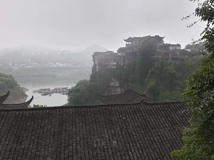 Stilted buildings of Furong Town perched above the river, Yongshun County, Xiangxi · 湘西土家族苗族自治州永顺县芙蓉镇,吊脚楼与河流 Source-recorded photograph date: 2017-05-31 07:03:54.
Furong Town芙蓉镇
Furong Town (芙蓉镇) stands on the north bank of the You river in Yongshun county, in the Xiangxi Tujia and Miao Autonomous Prefecture of Hunan. Water surrounds it on three sides and a stream falls through the settlement itself, which is why it is known as the old town hanging on a waterfall.
Read the place guide →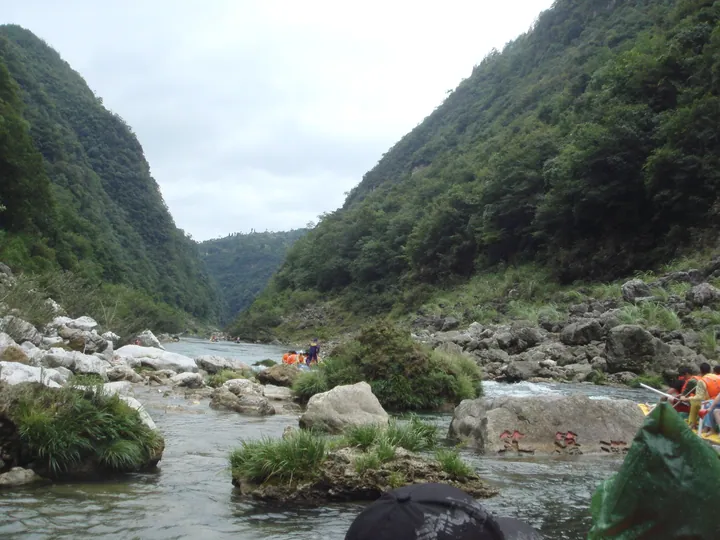 Rafters on the Mengdong River in its forested gorge, Yongshun County, Xiangxi · 湘西永顺县猛洞河漂流,峡谷中的漂流游客 Source-recorded photograph date: Taken on 30 August 2009.
Mengdong River Rafting猛洞河漂流
Mengdonghe rafting (猛洞河漂流) follows the Si river, a tributary of the Mengdong river, in Yongshun county in the Xiangxi Tujia and Miao Autonomous Prefecture of Hunan. The run begins at Hanigong, a little over ten kilometres from Furong Town.
Read the place guide →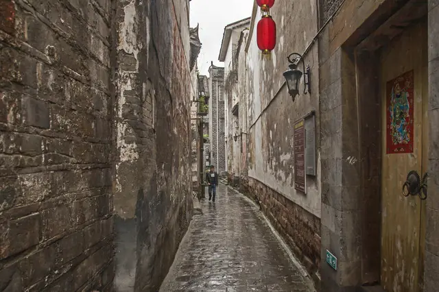 Pushi Ancient Town (浦市古镇), Luxi County. Photograph: "Path in Pushi ancient town, Hunan".
Pushi Ancient Town浦市古镇
Pushi (浦市古镇) is an old river town in the south-east of Luxi county, on the west bank of the middle reach of the Yuan river, in the Xiangxi Tujia and Miao Autonomous Prefecture of Hunan. It was designated a national historic and cultural town in 2010 and is one of the four old towns of Xiangxi.
Read the place guide → Chadong Border Town · 边城茶峒
Chadong Border Town边城茶峒
Chadong (边城茶峒) is an old town in Huayuan county, in the Xiangxi Tujia and Miao Autonomous Prefecture of Hunan, standing on the Qingshui river where Hunan, Chongqing and Guizhou meet. It is the place on which Shen Congwen modelled his novel Border Town, and in 2005 the township was renamed Biancheng after the book.
Read the place guide → Bamian Mountain · 八面山
Bamian Mountain八面山
Bamianshan (八面山) is a long, cliff-ringed mountain in the south of Longshan County, in the Xiangxi Tujia and Miao Autonomous Prefecture of Hunan, whose flat summit carries an expanse of high-altitude grassland above the town of Liye.
Read the place guide →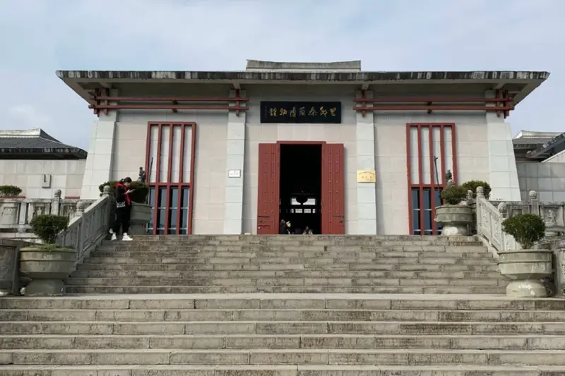 Liye Ancient City and Qin Bamboo Slips Museum · 里耶古城与秦简博物馆
Liye Ancient City and Qin Bamboo Slips Museum里耶古城与秦简博物馆
Liye (里耶古城与秦简博物馆) pairs an excavated walled town beside the You River in Liye Town, Longshan County, Hunan, with the museum that holds the tens of thousands of Qin-dynasty document slips found there.
Read the place guide → Rebala Tujia Villages · 惹巴拉
Rebala Tujia Villages惹巴拉
Rebala (惹巴拉) is a group of Tujia villages at the confluence of the Xiche and Dianfang rivers in Miao'ertan Town, Longshan County, in the Xiangxi Tujia and Miao Autonomous Prefecture of Hunan.
Read the place guide →Local life & food
Xiangxi Tujia and Miao Autonomous Prefecture local specialties
湘西土家族苗族自治州特色美食 · 11 specialties to discover
 Western Hunan cured meat 湘西腊肉AI dish illustration · AI 菜品示意图
The flavor is concentrated, salty and often smoky, with fat becoming translucent and rich when heated. Texture varies with the cut and length of curing.
Source ↗Read the dish guide → Fenghuang duck with blood-rice cakes 凤凰血粑鸭AI dish illustration / AI 菜品示意图
The dish is rich and savoury, with tender duck contrasting against firmer rice cakes. Chilli and aromatics vary by restaurant.
Source ↗Read the dish guide →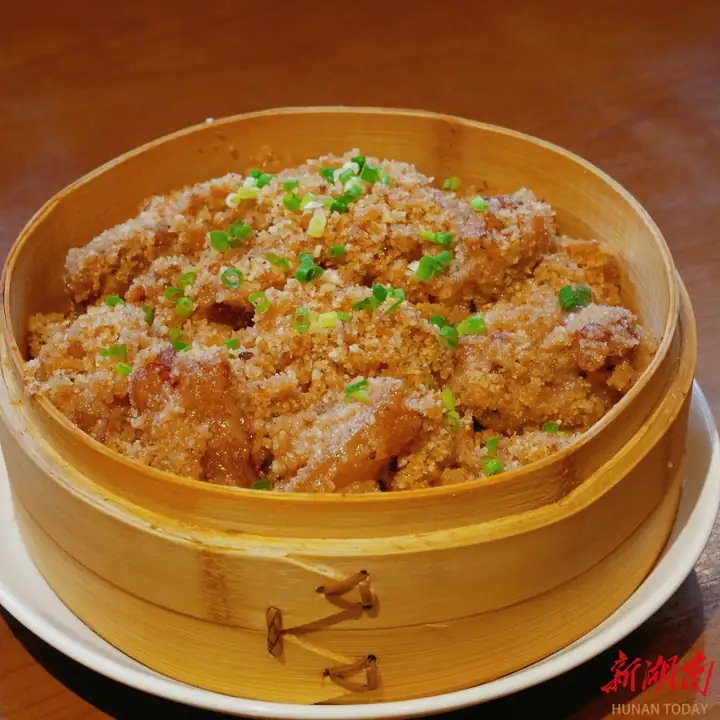 Jishou Sour-Cured Pork 吉首酸肉
Jishou Sour-Cured Pork (吉首酸肉) is listed among the local specialties of Xiangxi Tujia and Miao Autonomous Prefecture, Hunan. It is grouped here with meat & poultry dishes; retain the complete Chinese name when comparing local menus.
Read the dish guide →Photo adjustments
EXIF orientation normalized; resized without changing aspect ratio; converted to WebP. No subject edits.
 Yongshun Rice Tofu 永顺米豆腐Reference photo of a similar dish · 同类菜品参考照片
Yongshun Rice Tofu (永顺米豆腐) is the rice tofu of Yongshun County (永顺县) in the north of Xiangxi (湘西) prefecture, Hunan.
Read the dish guide →
Photo adjustments
Full frame retained; EXIF orientation normalized, proportionally resized to at most 800 pixels and converted to WebP. No generated pixels or subject changes. Cards may crop the display.
 Longshan Pork Stewed with Lily Bulbs 龙山百合炖肉AI illustration · AI 示意图(仅供参考,非实拍)
Longshan Pork Stewed with Lily Bulbs (龙山百合炖肉) is listed among the local specialties of Xiangxi Tujia and Miao Autonomous Prefecture, Hunan. 炖 describes slow simmering.
Read the dish guide → Miao-Style Sour Cured Fish 苗家酸鱼AI illustration · AI 示意图(仅供参考,非实拍)
Miao-Style Sour Cured Fish (苗家酸鱼) is a jar-cured fish of the Miao people of Xiangxi Tujia and Miao Autonomous Prefecture (湘西土家族苗族自治州), western Hunan.
Read the dish guide →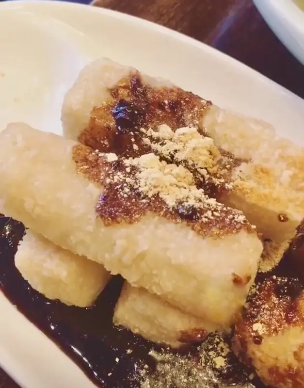 Xiangxi Pounded Sticky Rice Cakes 湘西糍粑Reference photo of a similar dish · 同类菜品参考照片
Xiangxi Pounded Sticky Rice Cakes (湘西糍粑) are flat rounds of steamed glutinous rice beaten into a dough and shaped by hand, made in western Hunan's Xiangxi (湘西) in the weeks before the Lunar New Year.
Read the dish guide →
Photo adjustments
Full frame retained; EXIF orientation normalized, proportionally resized to at most 800 pixels and converted to WebP. No generated pixels or subject changes. Cards may crop the display.
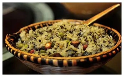 Wild Greens and Cured Pork Sticky Rice 社饭
Wild Greens and Cured Pork Sticky Rice (社饭) is a Tujia (土家族) festival food in Zhangjiajie (张家界), eaten for the she festival in the second lunar month. Its rice combines wild greens and onions with fragrant fried cured pork.
Read the dish guide →Photo adjustments
EXIF orientation normalized; resized without changing aspect ratio; converted to WebP. No subject edits.
All dish names · 全部菜名 (11)
- Western Hunan cured meat · 湘西腊肉
- Fenghuang duck with blood-rice cakes · 凤凰血粑鸭
- Jishou Sour-Cured Pork · 吉首酸肉
- Yongshun Rice Tofu · 永顺米豆腐
- Longshan Pork Stewed with Lily Bulbs · 龙山百合炖肉
- Miao-Style Sour Cured Fish · 苗家酸鱼
- Xiangxi Pounded Sticky Rice Cakes · 湘西糍粑
- Wild Greens and Cured Pork Sticky Rice · 社饭
- Fenghuang Ginger Candy · 凤凰姜糖
- Rice Tofu · 米豆腐
- Miao Sour Soup · 苗家酸汤
More dishes from across Hunan are in the Hunan food guide.
Counties & districts in Xiangxi Tujia and Miao Autonomous Prefecture
8 areas belong directly to Xiangxi Tujia and Miao Autonomous Prefecture.
8 areas
Jishou 吉首市
Jishou is a county-level city and the seat of Xiangxi Tujia and Miao Autonomous Prefecture, Hunan province, China.
Explore the area →CountyLuxi County 泸溪县
Luxi County (simplified Chinese: 泸溪县; traditional Chinese: 瀘溪縣; pinyin: Lúxī Xiàn) is a county of Hunan Province, China. It is under the administration of Xiangxi Autonomous Prefecture.
Explore the area →CountyFenghuang County 凤凰县
Fenghuang County (simplified Chinese: 凤凰县; traditional Chinese: 鳳凰縣; pinyin: Fènghuáng Xiàn), named after the mythological birds Fenghuang, is a county of Hunan Province, China, under the administration of…
Explore the area →CountyHuayuan County 花垣县
Huayuan County (simplified Chinese: 花垣县; traditional Chinese: 花垣縣; pinyin: Huāyuán Xiàn) is a county of Hunan Province, China. It is under the administration of Xiangxi Autonomous Prefecture.
Explore the area →Show fewer areas
Baojing County 保靖县
Baojing County (simplified Chinese: 保靖县; traditional Chinese: 保靖縣; pinyin: Bǎojìng Xiàn) is a county of Hunan Province, China. It is under the administration of Xiangxi Autonomous Prefecture.
Explore the area →CountyGuzhang County 古丈县
Guzhang County (simplified Chinese: 古丈县; traditional Chinese: 古丈縣; pinyin: Gǔzhàng Xiàn) is a county of Hunan Province, China.
Explore the area →CountyYongshun County 永顺县
Yongshun County (simplified Chinese: 永顺县; traditional Chinese: 永順縣; pinyin: Yǒngshùn Xiàn) is a county of Hunan Province, China. It is under the administration of Xiangxi Autonomous Prefecture.
Explore the area →CountyLongshan County 龙山县
Longshan County (simplified Chinese: 龙山县; traditional Chinese: 龍山縣; pinyin: Lóngshān Xiàn; lit. 'dragon mountain') is a county of Hunan Province, China.
Explore the area →No areas match this name.
Plan your visit
Getting there
Search for 湘西土家族苗族自治州 in a map app to find stations and your accommodation.
Where to stay →Build your route
Fenghuang Ancient Town and Laosicheng are about 120 km apart in a straight line. The linked place guides have entrance and visit details.
Continue with Hunan →More in Hunan
Sources & geographic information
Administrative names and parent areas: Official geographic directory · Reference date 2026-09-06.
Background text adapted from Xiangxi Tujia and Miao Autonomous Prefecture — Wikipedia contributors, under CC BY-SA 4.0. Text has been shortened and reorganized; source revision 1366787250.
Photo: Fenghuang Ancient Town · Vera & Jean-Christophe · CC BY-SA 2.0. Wikimedia thumbnail; fitted to the ranking-card frame.

Photo: Laosicheng · Source photographer · License not provided. EXIF orientation normalized; resized without changing aspect ratio; converted to WebP. No subject edits.
Photo: Aizhai Bridge · Glabb · CC BY-SA 3.0. Proportionally resized and converted to WebP without cropping, retouching or changing the photographed subject.

Photo: Dehang Grand Canyon · Glabb · CC BY-SA 3.0. Full frame retained; EXIF orientation normalized, proportionally resized to at most 800 pixels and converted to WebP. No generated pixels or subject changes. Cards may crop the display.

Photo: Ludong Mountain · Source photographer · License not provided. EXIF orientation normalized; resized without changing aspect ratio; converted to WebP. No subject edits.
Photo: Red Stone Forest · Popolon · CC BY-SA 4.0. Full frame retained; proportionally resized and converted to WebP. No retouching or changes to the photographed subject. Card displays may crop the view.

Photo: Zuolong Gorge · Source photographer · License not provided. EXIF orientation normalized; resized without changing aspect ratio; converted to WebP. No subject edits.
Photo: Dehang Miao Village and Canyon · Source photographer · License not provided. EXIF orientation normalized; resized without changing aspect ratio; converted to WebP. No subject edits.
Photo: Aizhai Bridge Viewing Area · Source photographer · License not provided. EXIF orientation normalized; resized without changing aspect ratio; converted to WebP. No subject edits.
Photo: Qianzhou Ancient City · Raki_Man · CC BY 3.0. Full frame retained; EXIF orientation normalized, proportionally resized to at most 800 pixels and converted to WebP. No generated pixels or subject changes. Cards may crop the display.

Photo: Furong Town · Popolon · CC BY-SA 4.0. Full frame retained; proportionally resized and converted to WebP. No retouching or changes to the photographed subject. Card displays may crop the view.

Photo: Mengdong River Rafting · john2636(強) · CC BY-SA 3.0. Full frame retained; proportionally resized and converted to WebP. No retouching or changes to the photographed subject. Card displays may crop the view.
.jpg)
Photo: Pushi Ancient Town · Allervous · CC BY-SA 4.0. Full frame retained; EXIF orientation normalized, proportionally resized to at most 800 pixels and converted to WebP. No generated pixels or subject changes. Cards may crop the display.

Photo: Chadong Border Town · Source photographer · License not provided. EXIF orientation normalized; resized without changing aspect ratio; converted to WebP. No subject edits.
Photo: Bamian Mountain · Source photographer · License not provided. EXIF orientation normalized; resized without changing aspect ratio; converted to WebP. No subject edits.
Photo: Liye Ancient City and Qin Bamboo Slips Museum · Source photographer · License not provided. EXIF orientation normalized; resized without changing aspect ratio; converted to WebP. No subject edits.
Photo: Rebala Tujia Villages · Source photographer · License not provided. EXIF orientation normalized; resized without changing aspect ratio; converted to WebP. No subject edits.
Map data © OpenStreetMap contributors. Pins mark approximate centres, not entrances or boundaries.