


Get to know Shuangpai County

Photo adjustments
Full frame retained; proportionally resized and converted to WebP. No retouching or changes to the photographed subject. Card displays may crop the view.
- Administrative area
- County · 县
- Part of
- Yongzhou
- Chinese name
- 双牌县
- Local areas
- County guide
Area & population
- Area in the source
- 1,739.32 km²
- Population · 2010
- 163,274
Source: cited geographic source, as of the dates shown.
Setting and landscape
The county is shaped like a saddle: high to the east and west, lower to the north and south, with ranges of hills through the centre. Tourism is organised around Yangming Mountain (阳明山) in the east, the reservoir lake on the Xiao River (潇水湖) in the centre, Zijin Mountain (紫金山) in the west, and the county town. The county town has hills on three sides and water on the fourth.
History
Shuangpai is a young county. In 1965 the Lingling prefectural committee grouped communes and state forest farms from Lingling (零陵县), Dao County (道县) and Ningyuan (宁远县) into a Xiaoshui forest district, and on 16 December 1969 that district became Shuangpai County. The old Chengguan town was renamed Longbo in 1995.
Earlier, Li Da (李达), a founder of the Communist Party, hid for several months in Taomuluo village (桃木漯村) on Zijin Mountain, and during the Long March the Red Sixth Army Group under Ren Bishi (任弼时), Xiao Ke (萧克) and Wang Zhen (王震) fought a guerrilla campaign around Zuyeyan (祖爷岩) on Yangming Mountain.
What to see
Yangming Mountain is a long-standing Buddhist pilgrimage mountain in southern Hunan and a national AAA scenic area. Its main sights include Wanshou Temple (万寿寺), Wanhe Lake (万和湖) and a sea of azaleas said to cover a hundred thousand mu, which is listed in Guinness World Records.
Along the Xiao River, the Shuangpai Reservoir dam holds back a long lake, with Qinglong Cave (青龙洞), Yueliangwan Island (月亮湾岛) and Huanglong Mountain (黄龙山) along its course. Zijin Mountain is named for the way morning and evening light turns it purple-gold; Yongshan (永山) and Yongshui (永水) on its north side are given by the county as the origin of the name Yongzhou. Behind the county town, living trees on a hillside spell out "绿化祖国" ("Green the Motherland"), another Guinness record.
Tongziao village (桐子坳村) in Chalin town (茶林镇) has more than 3,000 ginkgo trees; Xinhua photographed them turning gold in late November.
Getting oriented
The county government puts Shuangpai 35 kilometres from central Yongzhou and from Yongzhou airport. National Road 207, the Luoyang–Zhanjiang railway (洛湛铁路) and the Erenhot–Guangzhou expressway (二广高速) run north to south through the county, and the Lengshuitan–Daoxian expressway (冷道高速) passes the county town.
Highlights
- Yangming Mountain 阳明山: Buddhist mountain in the east of the county with Wanshou Temple and a Guinness-listed azalea sea.
- Tongziao ginkgo village 桐子坳: Village in Chalin town with more than 3,000 ginkgo trees that turn gold in late autumn.
- Zijin Mountain 紫金山: Western mountain whose Yongshan and Yongshui are given as the source of the name Yongzhou.
- Qinglong Cave 青龙洞: Sight north of the county town on the Xiao River lake.
Sources for this guide
县情概况_双牌县人民政府 · Shuangpai County People's Government
发展简史_双牌县人民政府 · Shuangpai County People's Government
双牌旅游产业_旅游资源_双牌县人民政府 · Shuangpai County People's Government
湖南双牌:满园银杏灿如金-新华网 · Xinhua
Original English written from the listed sources and checked sentence by sentence against quoted extracts by a separate reviewer. Updated 2026-09-25.
Explore Shuangpai County
Core places to explore, with English and Chinese names.
Places to explore around Shuangpai County
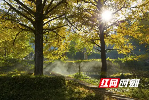 Tongzi'ao Village · 桐子坳
Tongzi'ao Village桐子坳
Tongziao (桐子坳) is a village in Chalin Town, Shuangpai County, Yongzhou, Hunan, whose reputation rests on its ginkgo grove rather than on its buildings. The scenic area around it covers about five square kilometres and is commonly called China's first ginkgo village.
Read the place guide →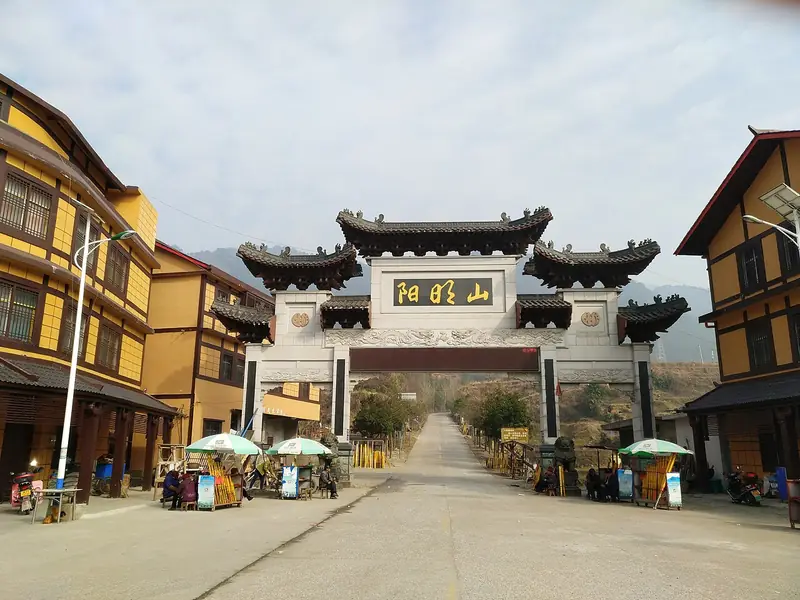 Yangming Mountain (阳明山), Shuangpai County. Photograph: "Gate of Yangmingshan National Forest Park (Hunan)".
Yangming Mountain阳明山
Yangmingshan (阳明山) is a national forest park in the north-east of Shuangpai County, Yongzhou, Hunan, on a spur of the Nanling range. Its highest point, Wangfotai, reaches 1,624.6 metres, and the mountain carries overlapping layers of protected forest, Buddhist pilgrimage tradition and Long March history.
Read the place guide →Plan your visit
Getting there
Shuangpai County is about 50 km in a straight line from central Yongzhou. Search for 双牌县 in a map app to find stations and your accommodation.
Where to stay →Build your route
Tongzi'ao Village and Yangming Mountain are both listed here. The linked place guides have entrance and visit details.
Continue with Yongzhou →More in Yongzhou
Sources & geographic information
Administrative names and parent areas: Official geographic directory · Reference date 2026-09-06.
Photo: Tongzi'ao Village · Source photographer · License not provided. EXIF orientation normalized; resized without changing aspect ratio; converted to WebP. No subject edits.
Photo: Yangming Mountain · Huangdan2060 · CC0. Full frame retained; EXIF orientation normalized, proportionally resized to at most 800 pixels and converted to WebP. No generated pixels or subject changes. Cards may crop the display.

Map data © OpenStreetMap contributors. Pins mark approximate centres, not entrances or boundaries.