


Get to know Bayan Obo Mining District
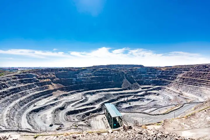
Photo adjustments
EXIF orientation normalized; resized without changing aspect ratio; converted to WebP. No subject edits.
- Administrative area
- District · 市辖区
- Part of
- Baotou
- Chinese name
- 白云鄂博矿区
- Local areas
- District guide
Area & population
- Area in the source
- 247.89 km²
- Population · 2020
- 22,681
- Administrative seat
- Tongyang Road Subdistrict
Source: cited geographic source, as of the dates shown.
Setting and landscape
The district lies at an average altitude of 1,605 metres, rising to 1,783 metres, and measures 33 kilometres north to south and 18.8 kilometres east to west. It is one of the country's main high-wind areas, with an average of 66.3 days of strong wind a year and more than 3,200 hours of sunshine a year; the district has built four wind-power and two solar-power companies.
History
The geologist Ding Daoheng (丁道衡) found the iron ore in 1927, and in 1934 the mineralogist He Zuolin (何作霖) identified rare-earth minerals in it. The area belonged to Darhan Muminggan United Banner (达尔罕茂明安联合旗) until Ulanqab League opened an office here in 1954; it passed to Baotou as a mining district in 1958. In 1953 Mongolian herders moved their obo (敖包), a sacred cairn, so that the mountain could be mined for the national steel industry. The deposit is the main raw-material base of the Baotou Steel group (包头钢铁), and by the end of 2025 it had yielded 27 newly named minerals.
What to see
The district is where the story of the "Grassland Heroic Little Sisters" (草原英雄小姐妹), Longmei (龙梅) and Yurong (玉荣), took place. Their exhibition hall, opened in September 2017, keeps many objects that the sisters authorised it to hold permanently, and a passage in the hall uses wind machines and 3D projection to recreate the night they spent in a snowstorm. The district government plans tourism around the mine, the grassland, the wind farms and local ornamental stones.
Getting oriented
Bayan Obo is 149 kilometres north of central Baotou and 212 kilometres northwest of Hohhot (呼和浩特), and 75 kilometres from the nearest point of the Mongolian border. A railway and road run north to the Mandula (满都拉) border crossing.
Highlights
- Grassland Heroic Little Sisters Exhibition Hall 草原英雄小姐妹事迹展览馆: Opened in 2017; recreates the sisters' night in a snowstorm and holds objects they authorised it to keep.
- Bayan Obo iron and rare-earth deposit 白云鄂博铁矿: Iron found in 1927 and rare earths in 1934; the main raw-material base of Baotou Steel.
Sources for this guide
白云鄂博——誉满全球的世界稀土之乡 · Bayan Obo Mining District People's Government
自然地理 · Bayan Obo Mining District People's Government
草原英雄小姐妹事迹展览馆简介 · Bayan Obo Mining District People's Government
白云鄂博矿区 · Wikipedia (Chinese) · CC BY-SA 4.0
Original English written from the listed sources and checked sentence by sentence against quoted extracts by a separate reviewer. Updated 2026-09-26.
Explore Bayan Obo Mining District
Core places to explore, with English and Chinese names.
Bayan Obo Mining District 白云鄂博矿区
Plan your visit
Getting there
Bayan Obo Mining District is about 130 km in a straight line from central Baotou. Search for 白云鄂博矿区 in a map app to find stations and your accommodation.
Where to stay →More in Baotou
Sources & geographic information
Administrative names and parent areas: Official geographic directory · Reference date 2026-09-06.
Some facts checked against 白云鄂博矿区 — Wikipedia contributors, CC BY-SA 4.0.
Map data © OpenStreetMap contributors. Pins mark approximate centres, not entrances or boundaries.