


Get to know Tumed Right Banner
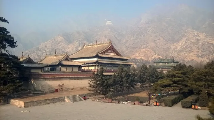
Photo adjustments
Full frame retained; proportionally resized and converted to WebP. No retouching or changes to the photographed subject. Card displays may crop the view.
- Administrative area
- Banner · 旗
- Part of
- Baotou
- Chinese name
- 土默特右旗
- Local areas
- Banner guide
Area & population
- Area in the source
- 2,323.64 km²
- Population · 2020
- 237,421
- Administrative seat
- Salqin
Source: cited geographic source, as of the dates shown.
Setting and landscape
The banner government sums up its land as one mountain, one plain and one river: the Daqing Mountains run for 60 kilometres along the north and hold coal and marble, the Yellow River flows for 108 kilometres along the south, and the plain in between covers about 2,000 square kilometres. The Jiufeng Mountain (九峰山) forest covers 12,500 hectares of secondary natural forest, which the banner describes as rare in central and western Inner Mongolia. The Beijing–Lanzhou railway, National Highway 110 and the G6 expressway cross the banner.
What to see
Meidaizhao began in 1572, when Altan Khan started building Lingjue Temple (灵觉寺) inside his walled town of Da Bansheng (大板升城), creating a place that was town and monastery at once. The earthen wall, faced with stone and 681 metres round, has corner towers; its main gate, Taihe Gate (泰和门), dates from 1606 and carries a plaque signed "Great Ming Golden Kingdom" (大明金国). Inside, the three-storey Liuli Hall (琉璃殿) is said to be where Altan Khan and his wife Sanniangzi (三娘子) received homage, and the Taihou Temple (太后庙) is said to be her memorial hall. The complex was listed as a major national heritage site in 1996, and the banner government notes 1,650 square metres of murals showing Ming–Mongol border trade.
The Chilechuan Museum (敕勒川博物馆) is rated a national second-class museum.
Culture, food and local products
The banner calls itself the home of Errentai (二人台), a local folk opera on the national intangible-heritage list that began in the Guangxu reign in the old Salaqi sub-prefecture (萨拉齐厅); it hosts the Inner Mongolia Errentai Arts Festival every two years. Tumochuan weddings mix Mongol and Han customs shaped by the westward "Zouxikou" (走西口) migration. The banner's golden apricot (金杏) festival opened for the eighteenth time at Meidaizhao in June 2026, with a food market of tofu banquets from Shuanglong town (双龙镇).
Highlights
- Meidaizhao 美岱召: Walled town and monastery begun by Altan Khan in 1572; major national heritage site since 1996.
- Jiufeng Mountain forest 九峰山: 12,500 hectares of secondary natural forest, which the banner calls rare in central and western Inner Mongolia.
- Errentai 二人台: National intangible heritage that began in Salaqi in the Guangxu reign.
- Golden apricots 金杏: Celebrated with a festival at Meidaizhao, held for the eighteenth time in 2026.
Sources for this guide
土默特右旗简介 · Tumed Right Banner People's Government
藏在土右旗的宝藏!今天,一起解锁身边的文化与自然之 · Tumed Right Banner People's Government
五年深耕文旅融合 敕勒川画卷徐徐铺展——土右旗文旅发展成效显著 · Tumed Right Banner People's Government
美岱召 · Chinese Wikipedia · CC BY-SA 4.0
杏香漫溢敕勒川!土右旗第十八届金杏旅游活动暨三娘子旅游文化消费季盛大启幕 · Tumed Right Banner People's Government
Original English written from the listed sources and checked sentence by sentence against quoted extracts by a separate reviewer. Updated 2026-09-25.
Explore Tumed Right Banner
Core places to explore, with English and Chinese names.
Places to explore around Tumed Right Banner
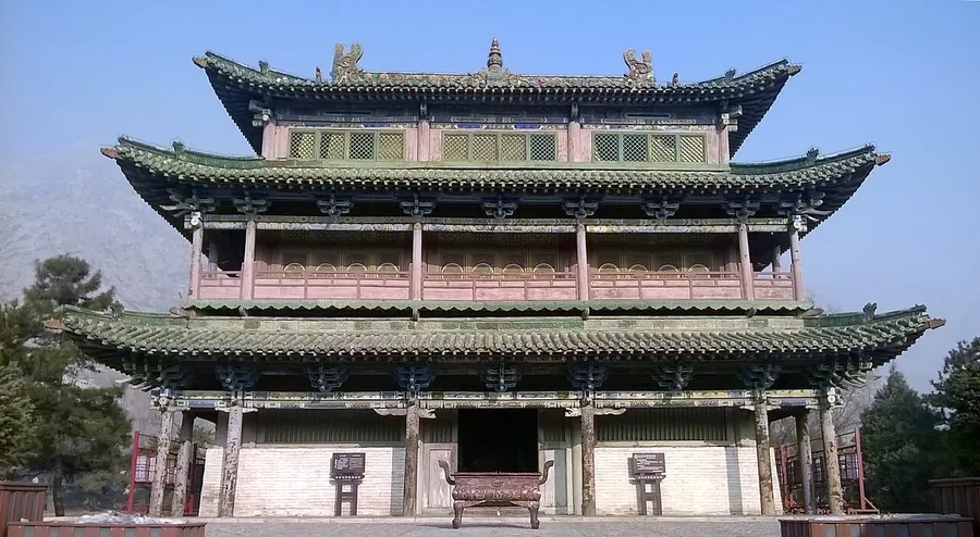 Liuli Hall inside the walled Meidaizhao complex, Inner Mongolia; 3 January 2016.
Plan your visit
Getting there
Tumed Right Banner is about 50 km in a straight line from central Baotou. Search for 土默特右旗 in a map app to find stations and your accommodation.
Where to stay →Build your route
Start with Meidaizhao. The linked place guides have entrance and visit details.
Continue with Baotou →More in Baotou
Sources & geographic information
Administrative names and parent areas: Official geographic directory · Reference date 2026-09-06.
Some facts checked against 美岱召 — Wikipedia contributors, CC BY-SA 4.0.
Photo: Meidaizhao · 三猎 · CC BY-SA 4.0. Proportionally resized and converted to WebP without cropping, retouching or changing the photographed subject.

Map data © OpenStreetMap contributors. Pins mark approximate centres, not entrances or boundaries.