


Get to know Shiguai District
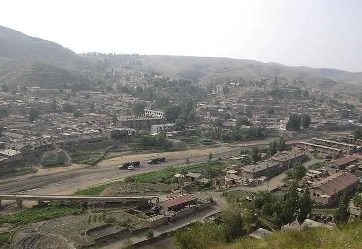
Photo adjustments
Full frame retained; proportionally resized and converted to WebP. No retouching or changes to the photographed subject. Card displays may crop the view.
- Administrative area
- District · 市辖区
- Part of
- Baotou
- Chinese name
- 石拐区
- Local areas
- District guide
Area & population
- Area in the source
- 775.40 km²
- Population · 2020
- 24,745
- Administrative seat
- Dadeheng Subdistrict
Source: cited geographic source, as of the dates shown.
Setting and landscape
Inner Mongolia News describes the district as hill country ringed by mountains, with loess hills cut by gullies in the middle. The old mining area lay in Baotou's north-eastern outskirts; in 2014 the district offices moved to the new town of Xiguitu (喜桂图新区), and the old Shiguai subdistrict is now the only urban subdistrict left in the old district. Inner Mongolia News also names a Warring States section of the Zhao Great Wall (赵长城) and the Aobao Mountain (敖包山) forest among the district's sights.
Coal-mining history
Baotou Daily traces coal mining here to the Yongzheng reign of the Qing, more than 300 years ago. In 1913 Kong Geng (孔庚) founded the Monan Mining Company (漠南矿业有限公司), described as Baotou's earliest modern national industrial enterprise. The Daqing Mountain coalfield was developed after 1949 as a First Five-Year Plan project paired with Baotou Steel, and the Baotou Mining Bureau was set up in 1958. By 2006 the district had produced 210 million tonnes of raw coal over 50 years. As the coal ran out from the late 1990s, the district was placed on the third national list of resource-exhausted cities in 2011, and more than 60,000 residents moved out of the old town.
Shiguai subdistrict (石拐街道), at the centre of the old district, has taken on a second role as the Daqing Mountain Film Base (大青山影视基地): as residents moved away, many old buildings stood empty, and period dramas such as Lichun (立春) have been shot there. Nearby, Dafa Street (大发街) keeps rows of former photo studios, barbers, repair shops and bookshops, and is being rebuilt as a historic district about 1,000 metres long, covering coal-industry, railway and everyday sites.
Wudang Lamasery
Wudang Lamasery lies in Jihulentu Sumu (吉忽伦图苏木), 54 kilometres north-east of Baotou city. It is a Gelug monastery whose 1749 expansion followed the plan of Tashilhunpo in Tibet, and in 1756 the Qianlong Emperor named it Guangjue Temple (广觉寺). Its buildings climb the hillside and hold 2,538 rooms; the largest, the 22-metre Sugqin Dugong (苏古沁独宫) assembly hall, dates from 1757 (one account gives 1755). Before 1949 the monastery itself mined the coal of present-day Shiguai. It was listed as a major national heritage site in 1996.
Highlights
- Wudang Lamasery 五当召: Gelug monastery modelled on Tashilhunpo, with 2,538 rooms; major national heritage site since 1996.
- Daqing Mountain Film Base 大青山影视基地: Shiguai subdistrict in the old mining district, used as a set for period dramas.
- Dafa Street 大发街: Old mining-town street being rebuilt as a historic district of coal, railway and everyday sites.
Sources for this guide
石拐区 · Chinese Wikipedia · CC BY-SA 4.0
五当召 · Chinese Wikipedia · CC BY-SA 4.0
老工业基地在绿色转型中焕发新气象——来自草原钢城一线的调查报告 · Xinhua
包头市石拐区:“百年矿城”的华丽转身 · Inner Mongolia News (nmgnews.com.cn)
大美中国·包头——石拐老区的矿山记忆 · Baotou News (Baotou Daily)
Original English written from the listed sources and checked sentence by sentence against quoted extracts by a separate reviewer. Updated 2026-09-25.
Explore Shiguai District
Core places to explore, with English and Chinese names.
Places to explore around Shiguai District
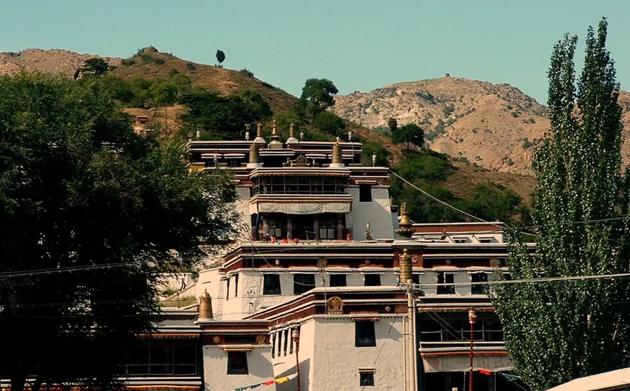 Wudangzhao (Wudang Lamasery), Inner Mongolia, photographed in 2005.
Plan your visit
Getting there
Shiguai District is about 25 km in a straight line from central Baotou. Search for 石拐区 in a map app to find stations and your accommodation.
Where to stay →Build your route
Start with Wudang Lamasery. The linked place guides have entrance and visit details.
Continue with Baotou →More in Baotou
Sources & geographic information
Administrative names and parent areas: Official geographic directory · Reference date 2026-09-06.
Some facts checked against 石拐区 — Wikipedia contributors, CC BY-SA 4.0.
Some facts checked against 五当召 — Wikipedia contributors, CC BY-SA 4.0.
Photo: Wudang Lamasery · Lukacs (Lukacs~commonswiki) · CC BY 2.5. Proportionally resized and converted to WebP without cropping, retouching or changing the photographed subject.

Map data © OpenStreetMap contributors. Pins mark approximate centres, not entrances or boundaries.