


Get to know Yunlong District

Photo adjustments
Full frame retained; proportionally resized and converted to WebP. No retouching or changes to the photographed subject. Card displays may crop the view.
- Administrative area
- District · 市辖区
- Part of
- Xuzhou
- Chinese name
- 云龙区
- Local areas
- District guide
Area & population
- Area in the source
- 118.00 km²
- Population · 2020 census
- 471,566
Source: cited geographic source, as of the dates shown.
What to see
The Lion Hill Chu king's tomb (狮子山楚王陵) is cut into the southern slope of the main peak of Lion Hill (狮子山). Han terracotta warriors found at the western foot of the hill in 1984 led archaeologists to the tomb in 1991, and it was excavated from December 1994 to March 1995. Carved into the rock and facing south, it runs 117 metres from north to south and has 12 chambers. Although probably robbed as early as the Xin dynasty, it still yielded more than 2,000 grave goods, including jade, gold and silver, bronze and coins. Its occupant is thought to be the second or third Western Han king of Chu. The four warrior pits held more than 2,300 painted pottery figures. The tomb was one of China's ten major archaeological finds of 1995 and was placed on the national key heritage list in 1996; it is preserved on site as part of the Xuzhou Han culture scenic area.
The Hubu Hill historic buildings (户部山古建筑群) surround Hubu Hill (户部山), formerly called South Hill. It took its present name after the Yellow River burst its banks in 1624 and the Ministry of Revenue's Xuzhou office moved up here to escape the flood. The raised ground drew wealthy families to build houses during the Ming and Qing, and thirteen fairly complete courtyard compounds with more than 500 rooms survive, among them the Zheng, Zhai and Yu family compounds and the mansion of the Hanlin academician Cui Tao (崔焘翰林府). The Yu and Zhai compounds now house the Xuzhou Folk Custom Museum (徐州民俗博物馆). The group was placed on the national key heritage list in 2006.
Getting oriented
The district borders the Xuzhou Economic Development Zone and the high-speed rail business district to the east. The district includes the Huaihai Road (淮海路) and Zhongshan Road (中山路) area, which Chinese Wikipedia describes as Xuzhou's centre for tourism, culture and services.
Highlights
- Lion Hill Chu king's tomb 狮子山楚王陵: Rock-cut Western Han royal tomb with pits of more than 2,300 painted pottery warriors; national key heritage site since 1996.
- Hubu Hill historic houses 户部山古民居: Thirteen Ming and Qing courtyard compounds on raised ground, two now the Xuzhou Folk Custom Museum; national key heritage site since 2006.
Sources for this guide
概况区划 · Yunlong District People's Government, Xuzhou
云龙区 · Chinese Wikipedia · CC BY-SA 4.0
狮子山汉楚王墓 · Chinese Wikipedia · CC BY-SA 4.0
户部山古建筑群 · Chinese Wikipedia · CC BY-SA 4.0
Original English written from the listed sources and checked sentence by sentence against quoted extracts by a separate reviewer. Updated 2026-09-25.
Explore Yunlong District
Core places to explore, with English and Chinese names.
Places to explore around Yunlong District
Excavated interior of the Chu Prince's Mausoleum at Shizishan, Xuzhou · 徐州狮子山楚王陵遗址内部 Photograph date recorded by the source: 9 August 2024, 14:11:57.Mausoleum of the Chu Prince狮子山楚王陵
The Shizishan tomb was cut into the southern slope of Lion Hill in Xuzhou and contains a complex series of rock chambers. Nearby Han-period terracotta pits held miniature officials, guards and armed figures, providing a…
Read the place guide →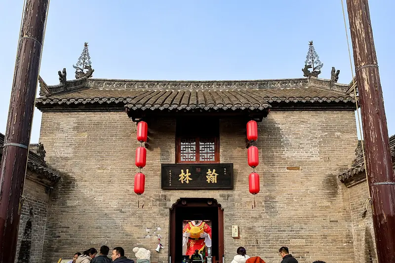 Hubushan Historic Residences (户部山古民居), Yunlong District. Photograph: "20260201 Ancient Buildings at Hubushan 03".
Hubushan Historic Residences户部山古民居
Hubushan Historic Residences in Xuzhou's Yunlong District preserves a hillside group of merchant and gentry homes whose architecture reflects the city's canal-era connections.
Read the place guide →Plan your visit
Getting there
Yunlong District is about 9 km in a straight line from central Xuzhou. Search for 云龙区 in a map app to find stations and your accommodation.
Where to stay →Build your route
Mausoleum of the Chu Prince and Hubushan Historic Residences are both listed here. The linked place guides have entrance and visit details.
Continue with Xuzhou →More in Xuzhou
Sources & geographic information
Administrative names and parent areas: Official geographic directory · Reference date 2026-09-06.
Some facts checked against 云龙区 — Wikipedia contributors, CC BY-SA 4.0.
Some facts checked against 狮子山汉楚王墓 — Wikipedia contributors, CC BY-SA 4.0.
Some facts checked against 户部山古建筑群 — Wikipedia contributors, CC BY-SA 4.0.
Photo: Mausoleum of the Chu Prince · Yumeto · Yumeto — 20240809_Shizishan_tomb.jpg — CC BY-SA 4.0 · CC BY-SA 4.0. Full frame retained; proportionally resized and converted to WebP. No retouching or changes to the photographed subject. Card displays may crop the view.

Photo: Hubushan Historic Residences · Windmemories · CC BY-SA 4.0. Full frame retained; EXIF orientation normalized, proportionally resized to at most 800 pixels and converted to WebP. No generated pixels or subject changes. Cards may crop the display.

Map data © OpenStreetMap contributors. Pins mark approximate centres, not entrances or boundaries.