


Get to know Wangqing County
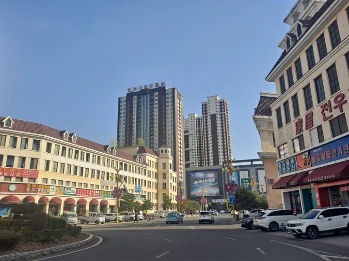
Photo adjustments
Full frame retained; proportionally resized and converted to WebP. No retouching or changes to the photographed subject. Card displays may crop the view.
- Administrative area
- County · 县
- Part of
- Yanbian Korean Autonomous Prefecture
- Chinese name
- 汪清县
- Local areas
- County guide
Area & population
- Area in the source
- 8,994.00 km²
- Administrative seat
- Wangqing Town (汪清镇)
Source: cited geographic source, as of the dates shown.
Setting and landscape
Forest covers 88.79 percent of the county, according to the county government, with red pine, oak, spruce, yew and linden among the valued trees, and three state forestry enterprises operate in the county. Three river systems drain it: the Gaya (嘎呀河), the Suifen (绥芬河) and the Hunchun (珲春河). Only about 7 percent of the land is farmed, most of it dry fields rather than paddy.
History
The county was created in 1909, and its name comes from a Manchu word for a fortress. During the war against Japan, Wangqing was the command centre of the anti-Japanese struggle in eastern Manchuria, according to the Yanbian Morning Post. The Xiaowangqing (小汪清) anti-Japanese base area keeps more than 20 sites and memorials, with rebuilt guerrilla camps, a district soviet office and the arsenal and printing works of the Communist Party's East Manchuria committee. Hongri village (红日村) in Daxinggou town (大兴沟镇), once the seat of the county party committee, has a Communist Party education hall.
What to see
Lanjia Grand Canyon National Forest Park (兰家大峡谷国家森林公园) in Fuxing town (复兴镇) has a stone river, a nine-step waterfall and a hanging lake, and the first footage in China of a wild Amur leopard with two cubs was filmed there. Mantianxing National Forest Park (满天星国家森林公园) lies in Baicaogou town (百草沟镇). In the county town, Pingfeng Mountain Ecological Park (屏风山生态公园) has a medicinal plant garden and boardwalks, and a hall on the Korean farmers' dance traces its history. The Wangqing County Cultural Centre is the protecting body for the Korean farmers' dance (hat-ribbon dance) (朝鲜族农乐舞(象帽舞)), on the first national intangible heritage list in 2006: young men whirl ribbons up to 20 metres long from their hats, standing, crouching or kneeling.
Food and local products
Baicaogou has a street of Korean restaurants known for soups of beef, river fish and soybean paste. Its small-fish soup (小鱼汤) is made by frying local small fish, then simmering them slowly with tofu, wild perilla, Korean soybean paste and small chillies. Wangqing barbecue favours small skewers of lamb, beef, pork, pig liver and tripe. Black wood-ear fungus comes first among the county's products, according to the Yanbian Morning Post: Wangqing Black Fungus (汪清黑木耳) carries a national geographical indication, valued for thick flesh and no stem.
Highlights
- Lanjia Grand Canyon National Forest Park 兰家大峡谷国家森林公园: Forest park in Fuxing town where a wild Amur leopard with two cubs was first filmed in China.
- Xiaowangqing anti-Japanese base area 小汪清抗日游击根据地遗址: More than 20 sites and memorials of the East Manchuria resistance to Japan.
- Korean farmers' dance (hat-ribbon dance) 朝鲜族农乐舞(象帽舞): National intangible heritage since 2006, protected by the Wangqing County Cultural Centre.
- Baicaogou small-fish soup 百草沟小鱼汤: Small local fish simmered with tofu, wild perilla, Korean soybean paste and chillies.
- Wangqing Black Fungus 汪清黑木耳: Wood-ear fungus with a national geographical indication.
Sources for this guide
魅力汪清 - 汪清县人民政府 · Wangqing County People's Government
汪清:山水红城铺开全域旅游美丽画卷 - 延边新闻网 · Yanbian Morning Post (Yanbian Daily group, ybrbnews.cn)
朝鲜族农乐舞(象帽舞) - 中国非物质文化遗产网 · China Intangible Cultural Heritage Network (ihchina.cn)
汪清县 - 维基百科,自由的百科全书 · Wikipedia (Chinese) · CC BY-SA 4.0
Wangqing County - Wikipedia · Wikipedia (English) · CC BY-SA 4.0
Original English written from the listed sources and checked sentence by sentence against quoted extracts by a separate reviewer. Updated 2026-09-25.
Explore Wangqing County
Core places to explore, with English and Chinese names.
Wangqing County 汪清县
Plan your visit
Getting there
Wangqing County is about 50 km in a straight line from central Yanbian Korean Autonomous Prefecture. Search for 汪清县 in a map app to find stations and your accommodation.
Where to stay →More in Yanbian Korean Autonomous Prefecture
Sources & geographic information
Administrative names and parent areas: Official geographic directory · Reference date 2026-09-06.
Some facts checked against 汪清县 — Wikipedia contributors, CC BY-SA 4.0.
Some facts checked against Wangqing County — Wikipedia contributors, CC BY-SA 4.0.
Map data © OpenStreetMap contributors. Pins mark approximate centres, not entrances or boundaries.