


Get to know Tumen
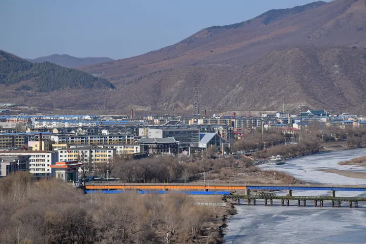
Photo adjustments
Full frame retained; proportionally resized and converted to WebP. No retouching or changes to the photographed subject. Card displays may crop the view.
- Administrative area
- County-level city · 县级市
- Part of
- Yanbian Korean Autonomous Prefecture
- Chinese name
- 图们市
- Local areas
- County-level city guide
Area & population
- Area in the source
- 1,142.70 km²
- Population · 2017
- 121,000
- Administrative seat
- Xiangshang Subdistrict
Source: cited geographic source, as of the dates shown.
Getting oriented
Tumen sits between Hunchun (珲春) to the east and the prefecture seat, Yanji (延吉), to the west, with Longjing (龙井) to the south and Wangqing County (汪清县) to the north. Its border with North Korea is 60.3 kilometres long, and the city government puts the Russian border 100 kilometres away and the Sea of Japan 130 kilometres away. Three railways pass through: the Changchun–Tumen and Tumen–Jiamusi lines, and the Changchun–Hunchun intercity line, which stops at Tumen North.
History
Chinese Wikipedia describes Tumen as a small village when Yanji County was set up in 1913. The city government dates the rail crossing to 1932, the opening of a trading port to 1933 and the road crossing to 1941. Tumen became a city in 1965 and was approved as a first-class open border city in 1985, the year a small land bridge rail service linking China, North Korea and Japan began through the port. In 1945 Japanese troops blew up the Onsong Bridge at Liangshui (凉水) to stop pursuing Soviet Red Army ground forces.
What to see
The Tumen port has a rail bridge of 439.96 metres and a road bridge of 514.92 metres into North Korea. The road port's gate, built in 1985 in the shape of the character for gate and 11 metres high, carries an inscription in Jiang Zemin's hand. At Liangshui, 23 kilometres from the city, 75 metres of the broken Onsong Bridge remain on the Chinese side. The Tingyan mountain fort (亭岩山城), north of Liangshui town, is an irregular triangle of stone walls with 31 barracks pits; experts cited by the city call it an important relic for studying the Bohai, Liao and Jin periods, and Jilin province listed it in 2007. The Hundred-Year Village (百年部落) at Bailong village in Yueqing town (月晴镇) has 26 Korean-style houses of different styles and uses, the oldest of them a typical Korean-style dwelling. Built together with the Tumen Children's Palace, the Chinese Korean Intangible Cultural Heritage Exhibition Hall (中国朝鲜族非物质文化遗产展览馆) shows 51 heritage items at various levels, 14 of them national.
Food and local products
Liangshui brand organic rice (凉水牌有机大米) comes from a prefecture organic rice base in a basin ringed by hills at Liangshui, where forest covers 68.8 percent of the land.
Highlights
- Tumen Port 图们口岸: Rail and road crossings into North Korea; the rail crossing dates from 1932.
- Liangshui Broken Bridge 凉水断桥: The Onsong Bridge, blown up by Japanese troops in 1945; 75 metres remain on the Chinese side.
- Tingyan Mountain Fort 亭岩山城: Stone-walled fort north of Liangshui, a provincial heritage site since 2007.
- Chinese Korean Intangible Cultural Heritage Exhibition Hall 中国朝鲜族非物质文化遗产展览馆: Displays 51 Korean heritage items, 14 at national level.
- Hundred-Year Village 百年部落: Group of 26 Korean-style houses at Bailong village, Yueqing town.
Sources for this guide
图们市情 - 图们市人民政府 · Tumen City People's Government
自然景观 - 图们市人民政府 · Tumen City People's Government
人文景观 - 图们市人民政府 · Tumen City People's Government
美食特产 - 图们市人民政府 · Tumen City People's Government
凉水断桥 - 图们市人民政府 · Tumen City People's Government
中国朝鲜族非物质文化遗产展览馆 - 图们市人民政府 · Tumen City People's Government
图们口岸国门 - 图们市人民政府 · Tumen City People's Government
图们市 - 维基百科,自由的百科全书 · Wikipedia (Chinese) · CC BY-SA 4.0
Original English written from the listed sources and checked sentence by sentence against quoted extracts by a separate reviewer. Updated 2026-09-25.
Explore Tumen
Core places to explore, with English and Chinese names.
Places to explore around Tumen
 AI illustration · AI
 Plan your visit
Getting there
Tumen is about 55 km in a straight line from central Yanbian Korean Autonomous Prefecture. Search for 图们市 in a map app to find stations and your accommodation.
Where to stay →Build your route
Start with Tumen River Port Riverfront. The linked place guides have entrance and visit details.
Continue with Yanbian Korean Autonomous Prefecture →More in Yanbian Korean Autonomous Prefecture
Sources & geographic information
Administrative names and parent areas: Official geographic directory · Reference date 2026-09-06.
Some facts checked against 图们市 — Wikipedia contributors, CC BY-SA 4.0.
Map data © OpenStreetMap contributors. Pins mark approximate centres, not entrances or boundaries.