


Get to know Xiuyan Manchu Autonomous County
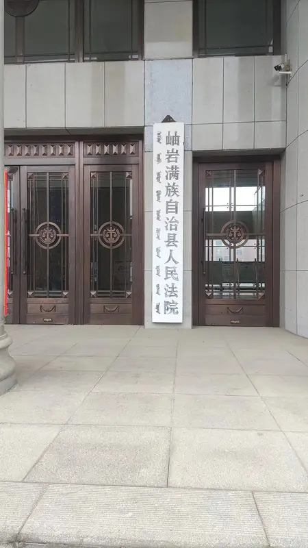
Photo adjustments
Full frame retained; EXIF orientation normalized, proportionally resized to at most 800 pixels and converted to WebP. No generated pixels or subject changes. Cards may crop the display.
- Administrative area
- Autonomous county · 自治县
- Part of
- Anshan
- Chinese name
- 岫岩满族自治县
- Local areas
- Autonomous county guide
Area & population
- Area in the source
- 4,502.00 km²
- Population · 2020 census
- 413,007
- Administrative seat
- Fuchang Subdistrict
Source: cited geographic source, as of the dates shown.
History
The Liao set up Daning town (大宁镇) north of the present county seat in 1115, and the Jin made it a county in 1193 under a name written with different characters (秀岩). The Ming gave it today's characters in 1375, the Qing made it a subprefecture in 1772, and it became a county again in 1913. The State Council created the Manchu autonomous county on 17 January 1985, and Xiuyan moved from Dandong (丹东) to Anshan in January 1992. The ruins of the mountain fortress on Wolong Mountain (卧龙山山城遗址), in Yangjiabao town (杨家堡镇), are a national key protected site.
What to see
Yaoshan (药山), the "medicine mountain", is a scenic area of 67.38 square kilometres 60 kilometres north of the county seat. More than forty peaks rise to Shihuading (石花顶) at 888.7 metres. A national survey recorded 486 kinds of medicinal herb here, and county tradition says Emperor Taizong of Tang renamed it in 645 after herbs cured his sick troops. Its temples include the Qinghua Temple (青华观) and Miaofeng Temple (妙峰寺). The Fengtian Gazetteer (奉天通志) records that in the Qing dynasty Yaoshan was counted among the four famous mountains of Fengtian (奉天).
Qingliang Mountain (清凉山), a national AAAA scenic area in Tanggou town (汤沟镇) in the northeast, rises to 1,141.5 metres at Maokui Mountain (帽盔山). It has a Liao-dynasty pagoda, an ice cave and a water cave with an underground river that visitors enter by boat.
The Xiuyan meteorite crater (岫岩陨石坑), in Gulong village of Suzigou town (苏子沟镇古龙村) 16 kilometres in a straight line from the county seat, is 1.8 kilometres across and 150 metres deep. In 2007 Professor Chen Ming (陈鸣) of the Chinese Academy of Sciences showed that a meteorite 60 to 100 metres wide made it about 50,000 years ago.
Crafts and local products
Xiuyan jade carving (岫岩玉雕) has been on the national intangible heritage list since 2006. Carved jade from Xiuyan has been found at Hongshan culture sites of five thousand years ago, and the local specialty is plain vessel work with linked rings and movable chains; a 3.15-metre jade incense tower from Xiuyan is kept in the Great Hall of the People. Xiuyan Manchu paper-cutting (岫岩满族剪纸) began when Manchu settled here in the early 17th century, and Xiuyan shadow puppetry (岫岩皮影戏) arrived in the Ming and Qing; both were listed in 2008. Xiuyan schisandra (岫岩辽五味子) is a national geographical-indication product.
Highlights
- Yaoshan 药山: Scenic area of forty-odd peaks and waterfalls, with 486 recorded medicinal herbs and old temples.
- Qingliang Mountain 清凉山: AAAA scenic area with a Liao pagoda, an ice cave and a boat-accessible water cave.
- Xiuyan meteorite crater 岫岩陨石坑: Crater 1.8 km across, made about 50,000 years ago, confirmed in 2007.
- Xiuyan jade carving 岫岩玉雕: National intangible heritage since 2006, known for linked rings and movable chains.
- Xiuyan Manchu paper-cutting 岫岩满族剪纸: Paper-cutting brought by Manchu settlers in the early 17th century.
Sources for this guide
岫岩满族自治县 - 维基百科,自由的百科全书 · Wikipedia (Chinese) · CC BY-SA 4.0
药山风景名胜区-游遍玉都-岫岩满族自治县人民政府 · Xiuyan Manchu Autonomous County Bureau of Culture, Tourism, Radio and Television
清凉山AAAA级风景区-游遍玉都-岫岩满族自治县人民政府 · Xiuyan Manchu Autonomous County Bureau of Culture, Tourism, Radio and Television
岫岩陨石坑地质公园-游遍玉都-岫岩满族自治县人民政府 · Xiuyan Manchu Autonomous County Bureau of Culture, Tourism, Radio and Television
岫岩玉雕 - 中国非物质文化遗产网·中国非物质文化遗产数字博物馆 - 中国非物质文化遗产网非遗 · China Intangible Cultural Heritage Network (Ministry of Culture and Tourism)
剪纸(岫岩满族剪纸) - 中国非物质文化遗产网·中国非物质文化遗产数字博物馆 - 中国非物质文化遗产网非遗 · China Intangible Cultural Heritage Network (Ministry of Culture and Tourism)
皮影戏(岫岩皮影戏) - 中国非物质文化遗产网·中国非物质文化遗产数字博物馆 - 中国非物质文化遗产网非遗 · China Intangible Cultural Heritage Network (Ministry of Culture and Tourism)
自然地理-自然地理-岫岩满族自治县人民政府 · Xiuyan Manchu Autonomous County People's Government
Original English written from the listed sources and checked sentence by sentence against quoted extracts by a separate reviewer. Updated 2026-09-25.
Explore Xiuyan Manchu Autonomous County
Core places to explore, with English and Chinese names.
Places to explore around Xiuyan Manchu Autonomous County
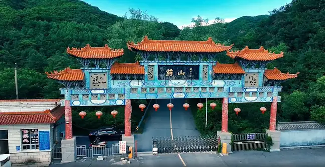 Mount Yaoshan ·
 Plan your visit
Getting there
Xiuyan Manchu Autonomous County is about 95 km in a straight line from central Anshan. Search for 岫岩满族自治县 in a map app to find stations and your accommodation.
Where to stay →Build your route
Start with Mount Yaoshan. The linked place guides have entrance and visit details.
Continue with Anshan →More in Anshan
Sources & geographic information
Administrative names and parent areas: Official geographic directory · Reference date 2026-09-06.
Some facts checked against 岫岩满族自治县 — Wikipedia contributors, CC BY-SA 4.0.
Photo: Mount Yaoshan · Source photographer · License not provided. EXIF orientation normalized; resized without changing aspect ratio; converted to WebP. No subject edits.
Map data © OpenStreetMap contributors. Pins mark approximate centres, not entrances or boundaries.