


Get to know Jinzhou District
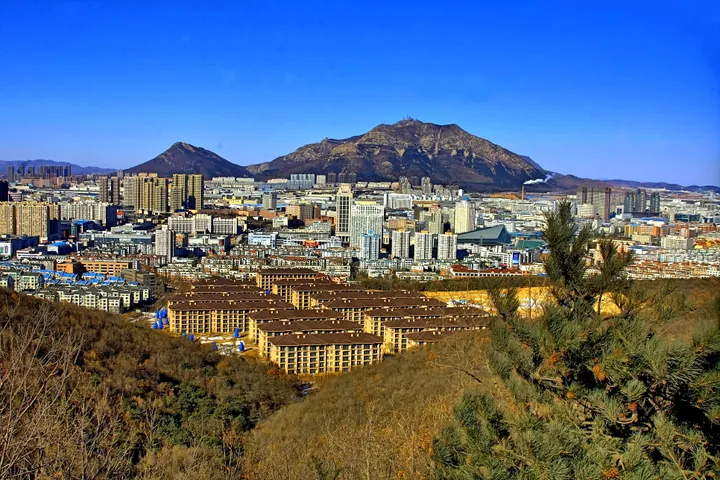
Photo adjustments
Full frame retained; proportionally resized and converted to WebP. No retouching or changes to the photographed subject. Card displays may crop the view.
- Administrative area
- District · 市辖区
- Part of
- Dalian
- Chinese name
- 金州区
- Local areas
- District guide
Area & population
- Area in the source
- 1,352.54 km²
- Population · 2020
- 1,545,491
Source: cited geographic source, as of the dates shown.
History
Under the Han the area formed Tashi county (沓氏县), whose seat is placed at Daling City (大岭城) in today's Dalijia subdistrict (大李家街道). The name Jinzhou dates from 1216, when the Jin dynasty raised Huacheng county (化成县) to a prefecture, and the Ming set up the Jinzhou Guard (金州卫) in 1375. Rebuilding of the walled town began in 1780 and turned the Ming plan into a rectangle, and by the mid-Qing four main streets divided the town in a grid. In 1843 the Xiongyue deputy lieutenant-general (熊岳副都统) moved here to strengthen coastal defence after the First Opium War.
The walls were badly damaged in the Sino-Japanese War of 1894–1895 and again in the Russo-Japanese War of 1904–1905. After Russia occupied Lüshunkou in 1897 it set up a Jinzhou administration, and Japan ruled the area from 1905. Soviet troops entered on 22 August 1945. The Dalian Economic and Technological Development Zone, approved in 1984, was China's first national-level development zone, and in 1987 Jin County became Jinzhou District.
What to see
The Dahei Mountain fortress (大黑山山城), also called Beisha City (卑沙城), is a Goguryeo stronghold of the late Eastern Jin. Its unworked-stone walls run for about 5 kilometres over the middle and south peaks of Dahei Mountain (大黑山), about 4 kilometres east of Jinzhou's main town, and the west gate is known as Guanmenzhaikou (关门寨口). The Liaoning Department of Culture and Tourism quotes the Book of Sui on the Sui general Lai Hu'er (来护儿) defeating Goguryeo forces here in 614. It became a national key protected site in 2013.
Other sights listed for the district include the Guanyin Pavilion of Shengshui Temple (胜水寺观音阁), Chaoyang Temple (朝阳寺), the Former Jinzhou Fudutong Office Museum (金州副都统衙署旧址博物馆), Xiangying Square (向应广场), the Stalin Road pedestrian street, a Dragon King Temple (龙王庙) and a Russo-Japanese War site at Nanshan (南山). Jinshitan National Tourist Resort (金石滩国家旅游度假区) includes the Discoveryland theme park (发现王国).
Getting oriented
China National Highways 201 and 202 cross the district. It is divided into 25 subdistricts, among them Jinshitan (金石滩街道), Dengshahe (登沙河街道) and Liangjiadian (亮甲店街道).
Highlights
- Dahei Mountain fortress (Beisha City) 大黑山山城: Goguryeo mountain fortress with 5 km of dry-stone walls; national key protected site since 2013.
- Former Jinzhou Fudutong Office Museum 金州副都统衙署旧址博物馆: Museum in the old office of the deputy lieutenant-general posted to Jinzhou in 1843.
- Nanshan Russo-Japanese War site 南山日俄战争遗址: Site of the Russo-Japanese War of 1904–1905.
- Jinshitan National Tourist Resort 金石滩国家旅游度假区: Resort area that includes the Discoveryland theme park.
Sources for this guide
金州区 - 维基百科 · Wikipedia (Chinese) · CC BY-SA 4.0
大黑山山城-辽宁省文化和旅游厅 · Liaoning Provincial Department of Culture and Tourism
大黑山山城 - 维基百科 · Wikipedia (Chinese) · CC BY-SA 4.0
Original English written from the listed sources and checked sentence by sentence against quoted extracts by a separate reviewer. Updated 2026-09-26.
Explore Jinzhou District
Core places to explore, with English and Chinese names.
Jinzhou District 金州区
Plan your visit
Getting there
Jinzhou District is about 25 km in a straight line from central Dalian. Search for 金州区 in a map app to find stations and your accommodation.
Where to stay →More in Dalian
Sources & geographic information
Administrative names and parent areas: Official geographic directory · Reference date 2026-09-06.
Some facts checked against 金州区 — Wikipedia contributors, CC BY-SA 4.0.
Some facts checked against 大黑山山城 — Wikipedia contributors, CC BY-SA 4.0.
Map data © OpenStreetMap contributors. Pins mark approximate centres, not entrances or boundaries.