


Get to know Wafangdian
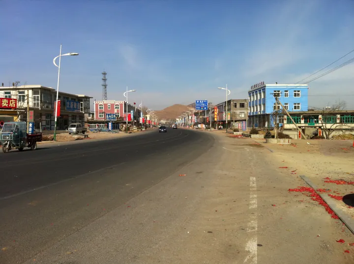
Photo adjustments
Full frame retained; proportionally resized and converted to WebP. No retouching or changes to the photographed subject. Card displays may crop the view.
- Administrative area
- County-level city · 县级市
- Part of
- Dalian
- Chinese name
- 瓦房店市
- Local areas
- County-level city guide
Area & population
- Area in the source
- 3,576.40 km²
- Population · 2010
- 942,197
- Administrative seat
- No. 1 Century Square (世纪广场1号)
Source: cited geographic source, as of the dates shown.
Setting and landscape
The land rises to the northeast and falls to the southwest, where outliers of the Qianshan range (千山) run down through low hills and plains to tidal flats. The city government sums up the mix as "six parts hills, one part water, three parts fields" (六山一水三分田). The coastline measures 461.2 kilometres, almost a quarter of Dalian's total.
The main river is the Fuzhou River (复州河), the second largest in the Dalian area. It rises on the southern slopes of Laomao Mountain (老帽山) in neighbouring Pulandian (普兰店), runs 137 kilometres and enters the Bohai Sea at Santaizi (三台子). The Songshu Reservoir (松树水库), built on its upper course in 1971, supplies the city's household and industrial water.
History
The Western Han set up Wen County (文县) here. In 404 a fortress called Deliying (得利赢城) was established on Longtan Mountain (龙潭山), in today's Delisi town (得利寺镇). Under the Liao the area became Fuzhou (复州), and in 1381 the Ming added the Fuzhou Garrison (复州卫). Fuzhou was turned into Fu County (复县) in 1913, and in December 1925 the county office moved from Fuzhoucheng (复州城) to Wafangdian. Fu County was abolished and the county-level city of Wafangdian created with State Council approval on 17 January 1985.
The name means "tiled-roof inn": under the Qing a merchant surnamed Qu built a tiled house here and opened an inn. The South Manchuria Railway later put a station at Wafangdian, and the town grew around it.
What to see
The Delisi Mountain Fortress (得利寺山城) on Longtan Mountain is a Goguryeo (高句丽) hill fort from the early 5th century, listed by the State Council in 2013 in the seventh batch of national key cultural relics. Wall foundations survive, with an east and a west gate and a stone-lined pond in the middle that local people call Longtan, the Dragon Pool. Delisi Temple (得利寺) inside the walls was destroyed in the Cultural Revolution and rebuilt in 1990. In June 1904, during the Russo-Japanese War, Russian troops tried to stop the Japanese advance around the fortress and suffered a heavy defeat.
Food and local products
Wafangdian is known in China for ball bearings and apples. The bearing industry goes back to a factory built under Japanese control during the Second World War. Diamonds are mined here as well: English Wikipedia puts the city's deposits at 54% of China's proven diamond reserves.
Highlights
- Delisi Mountain Fortress 得利寺山城: Early 5th-century Goguryeo hill fort on Longtan Mountain, listed as a national key cultural relic in 2013.
- Fuzhou River 复州河: The second-largest river in the Dalian area, 137 kilometres long, entering the Bohai Sea at Santaizi.
Sources for this guide
历史沿革_历史沿革_大连瓦房店 · Wafangdian Municipal People's Government
地理概况_地理概况_大连瓦房店 · Wafangdian Municipal People's Government
河流_河流_大连瓦房店 · Wafangdian Municipal People's Government
瓦房店市 - 维基百科,自由的百科全书 · Wikipedia (Chinese) · CC BY-SA 4.0
Wafangdian - Wikipedia · Wikipedia (English) · CC BY-SA 4.0
得利寺山城 - 维基百科,自由的百科全书 · Wikipedia (Chinese) · CC BY-SA 4.0
Original English written from the listed sources and checked sentence by sentence against quoted extracts by a separate reviewer. Updated 2026-09-25.
Explore Wafangdian
Core places to explore, with English and Chinese names.
Wafangdian 瓦房店市
Plan your visit
Getting there
Wafangdian is about 85 km in a straight line from central Dalian. Search for 瓦房店市 in a map app to find stations and your accommodation.
Where to stay →More in Dalian
Sources & geographic information
Administrative names and parent areas: Official geographic directory · Reference date 2026-09-06.
Some facts checked against 瓦房店市 — Wikipedia contributors, CC BY-SA 4.0.
Some facts checked against Wafangdian — Wikipedia contributors, CC BY-SA 4.0.
Some facts checked against 得利寺山城 — Wikipedia contributors, CC BY-SA 4.0.
Map data © OpenStreetMap contributors. Pins mark approximate centres, not entrances or boundaries.