


Get to know Zhongzheng District

Photo adjustments
Full-frame source proportionally resized and converted to WebP for display. No subject alteration. Source-supplied marks and edits remain; cards may crop the view.
- Administrative area
- District · 區
- Part of
- Keelung City
- Chinese name
- 中正區
- Local areas
- District guide
Area & population
- Area in the source
- 10.21 km²
Source: cited geographic source, as of the dates shown.
Setting and landscape
The district office describes a long strip of coast with many slopes and little flat ground, a long winter monsoon and frequent rain. At Badouzi (八斗子) in the north-east it meets Ruifang (瑞芳) in New Taipei, and the coast highway towards Yilan (宜蘭) begins here. Its natural sights include Heping Island Park, Huangdidian (皇帝殿), Badouzi Park and Wangyougu (忘憂谷).
History
Heping Island, 75 metres off the shore and linked by Heping Bridge (和平橋), was home to the Basay (巴賽族) people, who called it tuman. Spaniards built the fort of San Salvador (聖薩爾瓦多城) there, and it is described as the first place in northern Taiwan where Westerners set foot. The Sheliao East Battery (社寮東砲台) began as a base in the wars between the Spanish and the Dutch, with guns first set up in 1626; Liu Mingchuan (劉銘傳) rebuilt it in 1886, the Japanese rebuilt it again, and it became a Keelung city-designated monument in 2004.
In Haimen Park (海門公園) on Zhongzheng Road, a tomb holds the remains of Qing soldiers killed in the Sino-French War, gathered by local gentry under Japanese rule after road building exposed their bones. The same park marks Taiwan's levelling datum, the starting point of its height measurements.
What to see
Zhengbin Fishing Port (正濱漁港), south of Heping Island, was built by the Japanese in 1934, and the district office says it was Taiwan's largest fishing port under Japanese rule; the city government is developing it as a waterfront for weekend leisure. The abandoned concrete shell of the Agenna Shipyard (阿根納造船廠) was the end point of railway branches that carried gold ore from Jinguashi (金瓜石) for shipment to Japan, and after Japanese rule ended it was leased to an American yacht builder. The three-storey Zhupu Altar (主普壇) in Zhongzheng Park is the main stage of Keelung's Ghost Festival, its most important annual folk rite, and its ground floor is a museum of the festival's rituals and objects.
Zhengbin and Badouzi are the main fishing ports, and shops selling fishing tackle and bait gather along Zhongzheng Road and near Badouzi. National Taiwan Ocean University (國立臺灣海洋大學) and the Fisheries Research Institute (水產試驗所) are also in the district.
Highlights
- Heping Island 和平島: Basay homeland and site of the Spanish fort of San Salvador, linked by Heping Bridge.
- Sheliao East Battery 社寮東砲台: Rebuilt in 1886 by Liu Mingchuan; Keelung city-designated monument since 2004.
- Zhengbin Fishing Port 正濱漁港: Built in 1934; described by the district office as Taiwan's largest fishing port under Japanese rule.
- Agenna Shipyard 阿根納造船廠: Concrete ruin at the end of the gold-ore rail branches from Jinguashi.
- Zhupu Altar 主普壇: Main stage of Keelung's Ghost Festival, with a festival museum on the ground floor.
- Haimen Park 海門公園: Tomb of Qing soldiers of the Sino-French War and Taiwan's levelling datum.
Sources for this guide
基隆市中正區公所-區簡介-區簡介 · Zhongzheng District Office, Keelung City
基隆市中正區公所-觀光景點-正濱漁港彩色屋 · Zhongzheng District Office, Keelung City
基隆市中正區公所-觀光景點-阿根納造船廠 · Zhongzheng District Office, Keelung City
基隆市中正區公所-觀光景點-主普壇(中元祭祀文物館) · Zhongzheng District Office, Keelung City
基隆市中正區公所-觀光景點-民族英雄墓(海門公園) · Zhongzheng District Office, Keelung City
和平岛 - 维基百科,自由的百科全书 · Wikipedia · CC BY-SA 4.0
Original English written from the listed sources and checked sentence by sentence against quoted extracts by a separate reviewer. Updated 2026-09-25.
Explore Zhongzheng District
Core places to explore, with English and Chinese names.
Places to explore around Zhongzheng District
Coastal rock platform at Heping Island Park, with Keelung Island offshore · 和平岛公园海蚀岩台与远处基隆屿 Source-recorded photograph date: 2023-07-31 13:48:24.Heping Island和平島
Heping Island Geopark sits on Keelung’s northeastern coast, where waves and weather have shaped pale rock into mushroom-like forms and blocky platforms. Fossils and coastal plants add details to a walk that first appears to be…
Read the place guide →Eroded coastal rock platforms at Heping Island Park, with Keelung Islet offshore · 和平岛公园海蚀岩岸,远处为基隆屿 Source-recorded photograph date: 2023-07-31 13:48:24.Heping Island Park和平岛公园
Heping Island Park presents an eroded coastal landscape on an island connected to Keelung by Heping Bridge.
Read the place guide →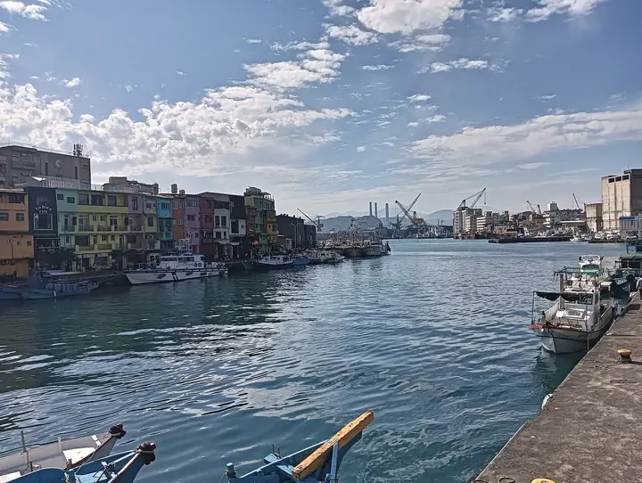 Zhengbin Fishing Port and its colourful waterfront buildings in Keelung · 基隆正滨渔港与彩色临港建筑 Source-recorded photograph date: 2025-03-02 14:48:30.
Zhengbin Fishing Port正滨渔港
Zhengbin Fishing Port is a historic harbour in Keelung, now especially recognised for the brightly painted building fronts along the waterfront.
Read the place guide →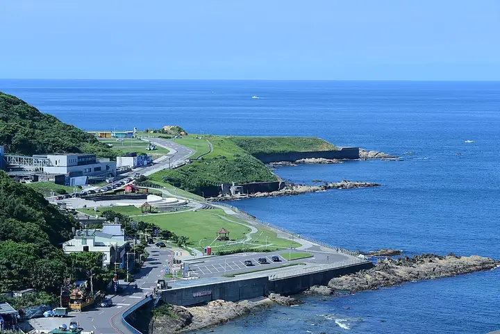 An elevated view of Chaojing Park and the Badouzi coast · 潮境公园与八斗子海岸的高处眺望 Source-recorded photograph date: 2021-06-03 15:12:50.
Chaojing Park潮境公园
Chaojing Park is an open coastal recreation space in Keelung's Zhongzheng District, beside the Badouzi area.
Read the place guide →Plan your visit
Getting there
Zhongzheng District is about 4 km in a straight line from central Keelung City. Search for 中正區 in a map app to find stations and your accommodation.
Where to stay →Build your route
Heping Island and Heping Island Park are both listed here. The linked place guides have entrance and visit details.
Continue with Keelung City →More in Keelung City
Sources & geographic information
Administrative names and parent areas: Official geographic directory · Reference date 2026-09-06.
Some facts checked against 和平岛 — Wikipedia contributors, CC BY-SA 4.0.
Photo: Heping Island · This Photo was taken by Supanut Arunoprayote. Feel free to use any of my images, but please mention me as the author and may send me a message. (สามารถใช้ภาพได้อิสระ แต่กรุณาใส่เครดิตผู้ถ่ายและอาจส่งข้อความบอกกล่าวด้วย) Please do not upload an updated image here without consultation with the Author. The author would like to make corrections only at his own source. This ensures that the changes are preserved.Please if you think that any changes should be required, please inform the author.Otherwise you can upload a new image with a new name. Please use one of the templates derivative or extract. · CC BY 4.0. Full-frame source proportionally resized and converted to WebP for display. No subject alteration. Source-supplied marks and edits remain; cards may crop the view.

Photo: Heping Island Park · This Photo was taken by Supanut Arunoprayote. Feel free to use any of my images, but please mention me as the author and may send me a message. (สามารถใช้ภาพได้อิสระ แต่กรุณาใส่เครดิตผู้ถ่ายและอาจส่งข้อความบอกกล่าวด้วย) Please do not upload an updated image here without consultation with the Author. The author would like to make corrections only at his own source. This ensures that the changes are preserved.Please if you think that any changes should be required, please inform the author.Otherwise you can upload a new image with a new name. Please use one of the templates derivative or extract. · CC BY 4.0. Full-frame source proportionally resized and converted to WebP for display. No subject alteration. Source-supplied marks and edits remain; cards may crop the view.
Photo: Zhengbin Fishing Port · Allervous · CC BY 4.0. Full-frame source proportionally resized and converted to WebP for display. No subject alteration. Source-supplied marks and edits remain; cards may crop the view.
.jpg)
Photo: Chaojing Park · Taiwankengo · CC BY-SA 4.0. Full-frame source proportionally resized and converted to WebP for display. No subject alteration. Source-supplied marks and edits remain; cards may crop the view.

Map data © OpenStreetMap contributors. Pins mark approximate centres, not entrances or boundaries.