


Get to know Dali District
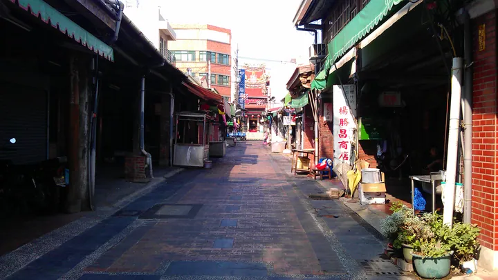
Photo adjustments
Full frame retained; proportionally resized and converted to WebP. No retouching or changes to the photographed subject. Card displays may crop the view.
- Administrative area
- District · 區
- Part of
- Taichung City
- Chinese name
- 大里區
- Local areas
- District guide
Area & population
- Area in the source
- 28.88 km²
Source: cited geographic source, as of the dates shown.
Old street and a reused meeting hall
Qingyuantang (慶源堂) preserves a timber house beside the old street, whose distinctive covered walkways have roofs separate from the houses. People still live in Qingyuantang, so the tourism bureau describes viewing it from outside. The former ferry wharf site lies at the street’s end. A 1929 neighbourhood leaders’ meeting hall later served as a household registration office and community centre, before becoming Daliyi Culture Museum (大里杙文化館) in 1999.
Local history and fibre crafts
The culture museum introduces the name Daliyi and the history of Pickled Vegetable Lane (鹹菜巷). At Taichung Museum of Fiber Arts (臺中市纖維工藝博物館), permanent displays explain fibre use through touch-based interaction, projected imagery and electronic books. Its themes connect fibre, fashion and environmentally conscious crafts.
Sources for this guide
臺中市大里區公所-休閒旅遊-大里杙休閒旅遊好風光 (https://www.dali.taichung.gov.tw/982726/982748/982754/1696340/1696409) · Taichung Dali District Office
travel.taichung.gov.tw (https://travel.taichung.gov.tw/zh-tw/tourist/tour/1100) · Taichung Tourism and Travel Bureau
Original English written from the listed sources and checked sentence by sentence against quoted extracts by a separate reviewer. Updated 2026-09-30.
Explore Dali District
Core places to explore, with English and Chinese names.
Dali District 大里區
Plan your visit
Getting there
Dali District is about 6 km in a straight line from central Taichung City. Search for 大里區 in a map app to find stations and your accommodation.
Where to stay →More in Taichung City
Sources & geographic information
Administrative names and parent areas: Official geographic directory · Reference date 2026-09-06.
Map data © OpenStreetMap contributors. Pins mark approximate centres, not entrances or boundaries.