


Get to know Hami

Photo adjustments
Full frame retained; proportionally resized and converted to WebP. No retouching or changes to the photographed subject. Card displays may crop the view.
- Administrative area
- Prefecture-level city · 地级市
- Part of
- Xinjiang
- Chinese name
- 哈密市
- Local areas
- 3 local areas
Area & population
- Area in the source
- 137,222.00 km²
- Population · 2020
- 673,383
- Administrative seat
- Yizhou District
Source: cited geographic source, as of the dates shown.
Transport
By road Hami is located along China National Highway 312, an east–west route of 4,967 km from Shanghai to Khorgas, Xinjiang in the Ili River valley, on the border with Kazakhstan.
Hami Yizhou Airport is a one-gate airport located 12.5 km northeast of the city center.
Explore Hami
Core places to explore, with English and Chinese names.
Places to explore around Hami
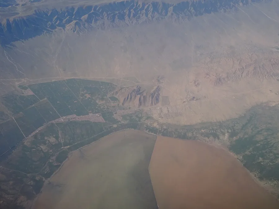 The shore of Barkol Lake and its surrounding fields and arid hills, photographed from a passenger aircraft. Photographed on 19 July 2018.
Barkol Lake巴里坤湖
Barkol Lake occupies a closed basin between the eastern Tianshan ranges. Its saline water, pale shore margins and surrounding wet meadow create a different landscape from the alpine freshwater lakes farther west. The lake also…
Read the place guide →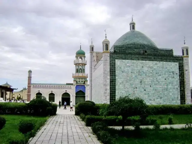 Hami Kings’ Tombs · 哈密回王陵
Hami Kings’ Tombs哈密回王陵
Hami’s royal tomb complex preserves buildings associated with the Qing-period Hami rulers and their families. The mausoleum of the seventh ruler, the ninth ruler’s tomb and the adjoining Id Kah mosque reveal different…
Read the place guide → AI illustration · AI 示意图(仅供参考,非该地点实拍)
Hami Museum哈密博物馆
Hami Museum introduces the eastern Xinjiang region through stone, bronze, pottery, wooden objects and preserved textiles. These collections connect the area’s settlements and burial sites with wider routes through the eastern…
Read the place guide → Yiwu Poplar Forest · 伊吾胡杨林
Yiwu Poplar Forest伊吾胡杨林
Yiwu poplar forest (伊吾胡杨林) is the Euphrates poplar stand at Naomaohu Township (淖毛湖镇), Yiwu County (伊吾县), Hami (哈密市), Xinjiang, covering 476,000 mu.
Read the place guide → Hami Hui Prince Mansion and Tombs (哈密回王府与回王陵), Yizhou District. Photograph: "哈密回王墓".
Hami Hui Prince Mansion and Tombs哈密回王府与回王陵
The Hami Prince scenic area (哈密王景区) in Yizhou District (伊州区), Hami (哈密市), Xinjiang, comprises the Hui Prince Mansion (回王府) and the Hui Prince Tombs (回王墓), the residence and burial complex of the Qing-dynasty Uygur princes of Hami.
Read the place guide → AI illustration · AI 示意图(仅供参考,非该地点实拍)
Dahaidao Yardang Official Route大海道正规开放线路
Dahaidao (大海道) is the yardang area of Yizhou District (伊州区), Hami (哈密市), Xinjiang, registered by the regional natural resources department as the Dahaidao yardang landform at Wubao Township (五堡乡).
Read the place guide → Barkol Grassland · 巴里坤草原
Barkol Grassland巴里坤草原
Barkol Grassland (巴里坤草原) is a grassland in Barkol Kazakh Autonomous County (巴里坤哈萨克自治县), Hami, Xinjiang, and the Barkol Lake scenic area (巴里坤湖景区) lies in its western part.
Read the place guide →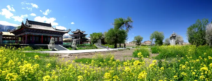 Barkol Ancient City · 巴里坤古城
Barkol Ancient City巴里坤古城
Barkol Ancient City (巴里坤古城) is the old walled county town of Barkol Kazakh Autonomous County (巴里坤哈萨克自治县) in Hami, Xinjiang, on the north slope of the East Tianshan; its surviving walls and gates are the core of a four-square-kilometre scenic area.
Read the place guide →Local life & food
Hami local specialties
哈密市特色美食 · 10 specialties to discover
 Hami Melon Rice 哈密瓜饭AI illustration · AI 示意图(仅供参考,非实拍)
Hami Melon Rice (哈密瓜饭) is listed among the local specialties of Hami, Xinjiang. It is grouped here with rice & congee; retain the complete Chinese name when comparing local menus.
Read the dish guide → Barkol Flaky Baked Bread 巴里坤油酥馍AI illustration · AI 示意图(仅供参考,非实拍)
Barkol Flaky Baked Bread (巴里坤油酥馍) is a round, flaky baked bread from Barkol Kazakh Autonomous County (巴里坤哈萨克自治县) in Hami (哈密), Xinjiang.
Read the dish guide →Barkol Steamed Bread 巴里坤蒸饼AI illustration · AI 示意图(仅供参考,非实拍)
Barkol Steamed Bread (巴里坤蒸饼) is a steamed cake from Barkol Kazakh Autonomous County (巴里坤哈萨克自治县) in Hami (哈密), Xinjiang.
Read the dish guide → Hami Mutton with Braised Flatbread 哈密羊肉焖饼
Hami Mutton with Braised Flatbread (哈密羊肉焖饼) is a dish of mutton braised under layers of paper-thin, hand-rolled flatbread, from Hami (哈密) in Xinjiang.
Read the dish guide →Photo adjustments
EXIF orientation normalized; resized without changing aspect ratio; converted to WebP. No subject edits.
 Hand-Grabbed Boiled Meat 手抓肉
Hand-Grabbed Boiled Meat (手抓肉) is a way of preparing bone-in meat associated with pastoral communities of the Junggar Basin (准噶尔盆地) and other northern grasslands.
Source ↗Read the dish guide →.jpg)
Photo adjustments
Full frame retained; proportionally resized and converted to WebP. No retouching or changes to the photographed subject. Card displays may crop the view.
 Grilled Lamb 烤羊肉
Grilled Lamb (烤羊肉) is listed among the local specialties of Karamay, Xinjiang. The name includes 羊肉 (lamb or mutton). 烤 describes roasting or grilling.
Read the dish guide →Photo adjustments
EXIF orientation normalized; resized without changing aspect ratio; converted to WebP. No subject edits.
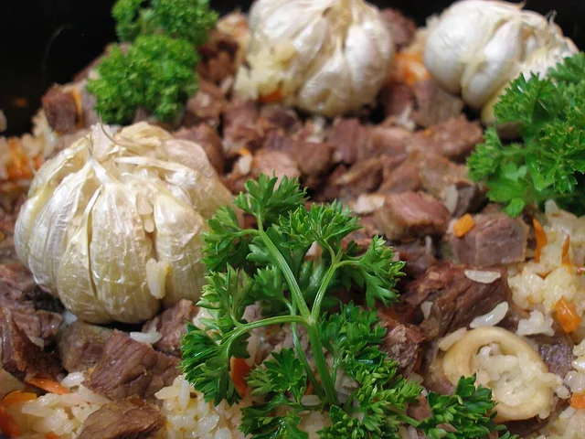 Polo rice 抓饭
The rice is rich and separate-grained, with sweet carrot, savory meat and occasional fruit sweetness rather than a sticky porridge texture.
Source ↗Read the dish guide →
Photo adjustments
EXIF orientation applied where present; resized proportionally to at most 640 px on the long edge and encoded as WebP. No crop, retouching, recoloring or subject changes.
 Nang bread 馕
Thin nang is crisp, while thicker bread has a soft, chewy center and toasted crust. Fresh warmth brings out the wheat and topping aromas.
Source ↗Read the dish guide →
Photo adjustments
EXIF orientation applied where present; resized proportionally to at most 640 px on the long edge and encoded as WebP. No crop, retouching, recoloring or subject changes.
More dishes from across Xinjiang are in the Xinjiang food guide.
Counties & districts in Hami
3 areas belong directly to Hami.
3 areas
Yizhou District 伊州区
Yizhou (Uyghur: ئىۋىرغول رايونى, romanized: Iwirghol; Chinese: 伊州; pinyin: Yīzhōu) is the central district of the Hami prefecture-level city, in Xinjiang Uyghur Autonomous Region, China.
Explore the area →Autonomous countyBarkol Kazakh Autonomous County 巴里坤哈萨克自治县
It forms part of the China–Mongolia border (bordering the Mongolian provinces of Khovd and Govi-Altai) on the county's north, while bordering Yizhou District to the south, Yiwu County to the east and…
Explore the area →CountyYiwu County 伊吾县
Yiwu County as the official romanized name, also transliterated from Uyghur as Aratürük County (Uyghur: ئارا تۈرۈك ناھىيىسى; Chinese: 阿热吐鲁克县), is a county in the northeast of the Xinjiang Uyghur Autonomous…
Explore the area →No areas match this name.
Plan your visit
Getting there
Search for 哈密市 in a map app to find stations and your accommodation.
Where to stay →Build your route
Barkol Lake and Hami Kings’ Tombs are about 95 km apart in a straight line. The linked place guides have entrance and visit details.
Continue with Xinjiang →More in Xinjiang
Sources & geographic information
Administrative names and parent areas: Official geographic directory · Reference date 2026-09-06.
Background text adapted from Hami — Wikipedia contributors, under CC BY-SA 4.0. Text has been shortened and reorganized; source revision 1372645066.
Photo: Barkol Lake · Tomskyhaha · CC BY-SA 4.0. Proportionally resized and converted to WebP without cropping, retouching or changing the photographed subject.

Photo: Hami Kings’ Tombs · Source photographer · License not provided. EXIF orientation normalized; resized without changing aspect ratio; converted to WebP. No subject edits.
Photo: Yiwu Poplar Forest · Source photographer · License not provided. EXIF orientation normalized; resized without changing aspect ratio; converted to WebP. No subject edits.
Photo: Hami Hui Prince Mansion and Tombs · Yanxutong1215 · CC BY-SA 4.0. Full frame retained; EXIF orientation normalized, proportionally resized to at most 800 pixels and converted to WebP. No generated pixels or subject changes. Cards may crop the display.

Photo: Barkol Grassland · Source photographer · License not provided. EXIF orientation normalized; resized without changing aspect ratio; converted to WebP. No subject edits.
Photo: Barkol Ancient City · Source photographer · License not provided. EXIF orientation normalized; resized without changing aspect ratio; converted to WebP. No subject edits.
Map data © OpenStreetMap contributors. Pins mark approximate centres, not entrances or boundaries.