


Get to know Bayingolin Mongol Autonomous Prefecture
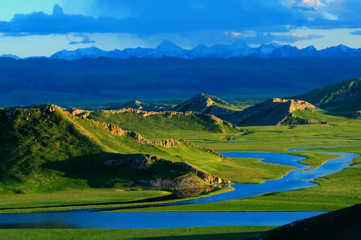
Photo adjustments
Full frame retained; proportionally resized and converted to WebP. No retouching or changes to the photographed subject. Card displays may crop the view.
- Administrative area
- Autonomous prefecture · 自治州
- Part of
- Xinjiang
- Chinese name
- 巴音郭楞蒙古自治州
- Local areas
- 9 local areas
Area & population
- Area in the source
- 471,480.28 km²
- Population · 2020
- 1,509,233
- Administrative seat
- Korla
Source: cited geographic source, as of the dates shown.
Explore Bayingolin Mongol Autonomous Prefecture
Core places to explore, with English and Chinese names.
Qiemo Museum 且末博物馆
Tazhong Desert Highway Rest Stop 塔中沙漠公路正规停靠点
Bosten Lake 博斯腾湖
Gongnaisi Forest Park 巩乃斯森林公园
Bayanbulak Grassland 巴音布鲁克
Lop People's Village 罗布人村寨
Peacock River and Korla Riverfront 孔雀河与库尔勒城市河岸
Loulan Museum 楼兰博物馆
Tarim Poplar Forest 塔里木胡杨林
Korla 库尔勒市
Luntai County 轮台县
Yuli County 尉犁县
Ruoqiang County 若羌县
Qiemo County 且末县
Yanqi Hui Autonomous County 焉耆回族自治县
Hejing County 和静县
Hoxud County 和硕县
Bohu County 博湖县
Places to explore around Bayingolin Mongol Autonomous Prefecture
 AI illustration · AI 示意图(仅供参考,非该地点实拍)
Qiemo Museum且末博物馆
Qiemo County Museum (且末县博物馆) is the county museum of Qiemo County (且末县) in Bayingolin Mongol Autonomous Prefecture, Xinjiang, opened in 2009 and given new displays in 2023.
Read the place guide → AI illustration · AI 示意图(仅供参考,非该地点实拍)
Tazhong Desert Highway Rest Stop塔中沙漠公路正规停靠点
Tazhong (塔中) is a desert town in the north-west of Qiemo County (且末县), Bayingolin Mongol Autonomous Prefecture, Xinjiang, in the central Taklamakan Desert, on the highway that crosses the sand from north to south.
Read the place guide → A wooden boardwalk and lakeside pavilion at Bosten Lake National Wetland Park, Bohu County · 博斯腾湖国家湿地公园的木栈道与湖边亭台,博湖县 Source-recorded photograph date: 2018-09-16 15:33:54.
Bosten Lake博斯腾湖
Bosten Lake brings a broad expanse of water and reed habitat to the northeastern Tarim Basin. The Kaidu River feeds the lake, linking it with the wider river system around Korla. Dahekou focuses on the open lakeshore and visitor…
Read the place guide →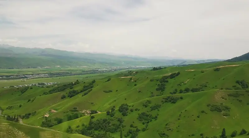 Gongnaisi Forest Park · 巩乃斯森林公园
Gongnaisi Forest Park巩乃斯森林公园
Gongnaisi (巩乃斯) is a valley and mountain scenic area in Hejing County (和静县), Bayingolin Mongol Autonomous Prefecture, Xinjiang; the name means "green valley" in Mongolian, and the scenic area includes a national forest park.
Read the place guide →The Kaidu River winding through Bayinbuluke grassland at sunset, Hejing County · 和静县巴音布鲁克草原,夕阳下蜿蜒的开都河 Source-recorded photograph date: 2009-06-28 21:35.Bayanbulak Grassland巴音布鲁克
High Tianshan grassland in Hejing County, Xinjiang, with the looping upper Kaidu River, marshes and Swan Lake; a 5A scenic area since 2016.
Read the place guide → Camel caravan crossing sand dunes above a desert oasis at Luoburen Cunzhai (Lop Nur People's Village), Yuli County, Bayingolin · 巴音郭楞蒙古自治州尉犁县罗布人村寨沙漠驼队 Source-recorded photograph date: Taken on 30 September 2007.
Lop People's Village罗布人村寨
Lop Village (罗布人村寨) is a national 4A-grade scenic area in Duokuotan township (墩阔坦乡), Yuli County (尉犁县), Bayingolin Mongol Autonomous Prefecture, Xinjiang, on the north-eastern edge of the Tarim Basin, where desert, poplar forest, river and lake meet.
Read the place guide →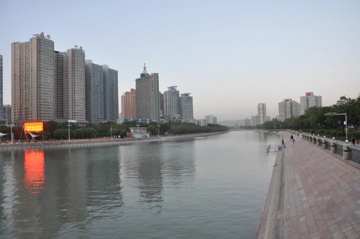 The Konqi River running away through Korla at dusk: a stone-paved promenade with balustrades and lamps along the right bank, a long row of apartment towers with a lit LED billboard on the left bank, its orange glow reflected in the water, and low hills and haze at the horizon.
Peacock River and Korla Riverfront孔雀河与库尔勒城市河岸
The Peacock River (孔雀河) runs through Korla (库尔勒市) in the Bayingolin Mongol Autonomous Prefecture, Xinjiang, and the catalogue label 孔雀河与库尔勒城市河岸 is an editorial one covering the river and the banks built along it in the city.
Read the place guide →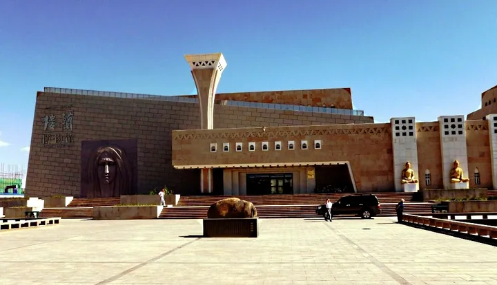 The Loulan Museum building in Ruoqiang County, with its distinctive stone facade and tower · 若羌县楼兰博物馆建筑,独特的石质外墙与塔楼 Source-recorded photograph date: 2011-06-21.
Loulan Museum楼兰博物馆
The Loulan Museum (楼兰博物馆) is a museum in Ruoqiang County (若羌县), Bayingolin Mongol Autonomous Prefecture, Xinjiang, given to the archaeology and history of Loulan and the Silk Road, and it opened on 3 May 2011.
Read the place guide → AI illustration · AI 示意图(仅供参考,非该地点实拍)
Tarim Poplar Forest塔里木胡杨林
The Tarim Poplar Forest (塔里木胡杨林) is the poplar forest of the Tarim River basin in Xinjiang; in Luntai County (轮台县), Bayingolin Mongol Autonomous Prefecture, the Tarim Poplar Forest Park (塔里木胡杨林公园) described on the county's tourism pages is a 4A-grade scenic area at the 70-kilometre point of the desert highway south of Luntai.
Read the place guide →Local life & food
Bayingolin Mongol Autonomous Prefecture local specialties
巴音郭楞蒙古自治州特色美食 · 10 specialties to discover
 Korla Fragrant Pear Pilaf 库尔勒香梨抓饭
Korla Fragrant Pear Pilaf (库尔勒香梨抓饭) is listed among the local specialties of Bayingolin Mongol Autonomous Prefecture, Xinjiang. It is grouped here with rice & congee; retain the complete Chinese name when comparing local menus.
Read the dish guide →Photo adjustments
EXIF orientation normalized; resized without changing aspect ratio; converted to WebP. No subject edits.
 Yuli Lop-Style Grilled Fish 尉犁罗布人烤鱼AI illustration · AI 示意图(仅供参考,非实拍)
Yuli Lop-Style Grilled Fish (尉犁罗布人烤鱼) is documented at Lop People’s Village (罗布人村寨) in Yuli County (尉犁).
Read the dish guide → Bohu Fish Banquet 博湖鱼宴AI illustration · AI 示意图(仅供参考,非实拍)
Bohu Fish Banquet (博湖鱼宴) is a meal of fish dishes cooked from the wild catch of Bosten Lake (博斯腾湖), which lies on the southern side of the Tianshan in Bohu County (博湖县), Bayingolin Mongol Autonomous Prefecture (巴音郭楞蒙古自治州).
Read the dish guide → Luntai Roast Lamb 轮台烤羊AI illustration · AI 示意图(仅供参考,非实拍)
Luntai Roast Lamb (轮台烤羊) is listed among the local specialties of Bayingolin Mongol Autonomous Prefecture, Xinjiang. The name includes 羊 (sheep). 烤 describes roasting or grilling.
Read the dish guide →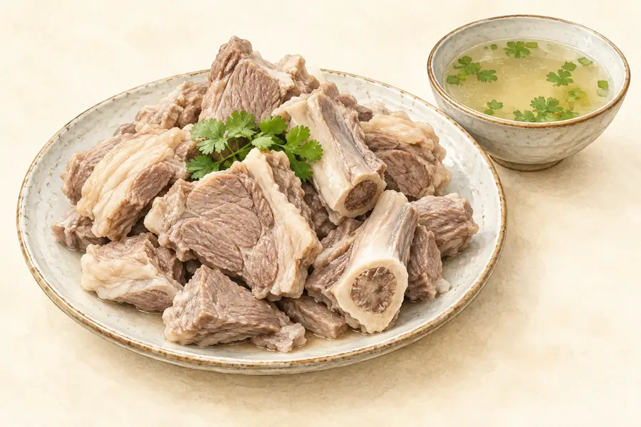 Hejing Torghut Hand-Held Mutton 和静土尔扈特手把肉AI illustration · AI 示意图(仅供参考,非实拍)
Hejing Torghut Hand-Held Mutton (和静土尔扈特手把肉) is lamb boiled on the bone and eaten with the hands, as served in Hejing County (和静县) in the Bayingolin Mongol Autonomous Prefecture (巴音郭楞蒙古自治州), Xinjiang.
Read the dish guide →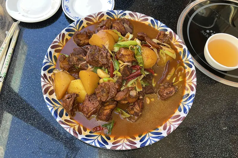 Yanqi Big Plate Chicken 焉耆大盘鸡Reference photo of a similar dish · 同类菜品参考照片
Yanqi Big Plate Chicken (焉耆大盘鸡) is dapanji, the Xinjiang dish of chicken, potatoes and chillies served on one large platter, as it is made with the dried chilli of Yanqi County (焉耆县).
Read the dish guide →
Photo adjustments
Full frame retained; EXIF orientation normalized, proportionally resized to at most 800 pixels and converted to WebP. No generated pixels or subject changes. Cards may crop the display.
 Ruoqiang Red Jujube Pilaf 若羌红枣抓饭AI illustration · AI 示意图(仅供参考,非实拍)
Ruoqiang Red Jujube Pilaf (若羌红枣抓饭) is listed among the local specialties of Bayingolin Mongol Autonomous Prefecture, Xinjiang. The name includes 红枣 (jujubes).
Read the dish guide → Nang bread 馕
Thin nang is crisp, while thicker bread has a soft, chewy center and toasted crust. Fresh warmth brings out the wheat and topping aromas.
Source ↗Read the dish guide →
Photo adjustments
EXIF orientation applied where present; resized proportionally to at most 640 px on the long edge and encoded as WebP. No crop, retouching, recoloring or subject changes.
All dish names · 全部菜名 (10)
More dishes from across Xinjiang are in the Xinjiang food guide.
Counties & districts in Bayingolin Mongol Autonomous Prefecture
9 areas belong directly to Bayingolin Mongol Autonomous Prefecture.
9 areas
Korla 库尔勒市
Korla, also known as Kurla or Kuerle, is the second largest city by population in Xinjiang, China. It is a county-level city and the seat of Bayingolin Mongol Autonomous Prefecture, the largest prefecture of…
Explore the area →CountyLuntai County 轮台县
Luntai County, also known as Bugur County or Bügür County (transliterated from Mongolian), is a county in central Xinjiang Uyghur Autonomous Region under the administration of the Bayin'gholin Mongol…
Explore the area →CountyYuli County 尉犁县
Yuli County as the official Romanized name, also transliterated from Mongolian as Lopnur County (Lop Nur), is a county in the Xinjiang Uyghur Autonomous Region and is under the administration of the…
Explore the area →CountyRuoqiang County 若羌县
Ruoqiang County as the official romanized name, also transliterated from Uyghur as Qakilik County (Uyghur: چاقىلىق ناھىيىسى; Chinese: 卡克里克县), is a county in the Xinjiang Uyghur Autonomous Region, China under…
Explore the area →Show fewer areas
Qiemo County 且末县
Qiemo County as the official romanized name, also transliterated from Uyghur as Qarqan County (Uyghur: چەرچەن ناھىيىسى; Chinese: 恰尔羌县), is a county under the administration of the Bayin'gholin Mongol…
Explore the area →Autonomous countyYanqi Hui Autonomous County 焉耆回族自治县
Yanqi Hui Autonomous County (Uyghur: Qarasheher, Karashahr) is an autonomous county in the Xinjiang Uyghur Autonomous Region and is under the administration of the Bayin'gholin Mongol Autonomous Prefecture.
Explore the area →CountyHejing County 和静县
Hejing County is located in the central-southern part of the Tian Shan mountains of Xinjiang, in the north-west of Bayingolin Mongol Autonomous Prefecture.
Explore the area →CountyHoxud County 和硕县
Hoxud County is a county in the Xinjiang Uyghur Autonomous Region and is under the administration of the Bayin'gholin Mongol Autonomous Prefecture. It contains an area of 12,753 km² (4,924 sq mi).
Explore the area →CountyBohu County 博湖县
Bohu County as the official romanized name, also transliterated from Uyghur as Bagrax County (Uyghur: باغراش ناھىيىسى; Chinese: 博斯腾县), is a county in the central part of the Xinjiang Uyghur Autonomous Region…
Explore the area →No areas match this name.
Plan your visit
Getting there
Search for 巴音郭楞蒙古自治州 in a map app to find stations and your accommodation.
Where to stay →Build your route
Qiemo Museum and Tazhong Desert Highway Rest Stop are both listed here. The linked place guides have entrance and visit details.
Continue with Xinjiang →More in Xinjiang
Sources & geographic information
Administrative names and parent areas: Official geographic directory · Reference date 2026-09-06.
Background text adapted from Bayingolin Mongol Autonomous Prefecture — Wikipedia contributors, under CC BY-SA 4.0. Text has been shortened and reorganized; source revision 1371048694.
Photo: Bosten Lake · liuxingy2015 · CC BY 2.0. Full frame retained; proportionally resized and converted to WebP. No retouching or changes to the photographed subject. Card displays may crop the view.

Photo: Gongnaisi Forest Park · Source photographer · License not provided. EXIF orientation normalized; resized without changing aspect ratio; converted to WebP. No subject edits.
Photo: Bayanbulak Grassland · lwtt93 from Shanghai, China · CC BY 2.0. Full frame retained; proportionally resized and converted to WebP. No retouching or changes to the photographed subject. Card displays may crop the view.
.jpg)
Photo: Lop People's Village · ts5init · CC BY 3.0. Full frame retained; proportionally resized and converted to WebP. No retouching or changes to the photographed subject. Card displays may crop the view.

Photo: Peacock River and Korla Riverfront · liuzusai刘祖赛 · CC BY 3.0. Full frame retained; proportionally resized and converted to WebP. No retouching or changes to the photographed subject. Card displays may crop the view.
.jpg)
Photo: Loulan Museum · John Hill · CC BY-SA 3.0. Full frame retained; proportionally resized and converted to WebP. No retouching or changes to the photographed subject. Card displays may crop the view.

Map data © OpenStreetMap contributors. Pins mark approximate centres, not entrances or boundaries.