


Get to know Shawan

- Administrative area
- County-level city · 县级市
- Part of
- Tacheng Prefecture
- Chinese name
- 沙湾市
- Local areas
- County-level city guide
Area & population
- Area in the source
- 12,458.16 km²
- Population · 2020
- 301,046
- Administrative seat
- Sadawkhuza (Sandaohezi)
Source: cited geographic source, as of the dates shown.
Four mountain landscape belts
Lujiaowan lies sixty kilometres south of Shawan’s administrative seat. Its name refers to antlers shed by the red deer that formerly inhabited the area, leaving antler material in mountain gullies and beside water. The scenic area contains four vertical landscape belts: snowy peaks and glaciers, bare alpine rock, mountain pine forest and alpine grassland.
A river through coloured strata
Anjihai Grand Canyon lies west of Anjihai Town (安集海镇), on the northern slopes of the Tianshan Mountains (天山). The valley has numerous terraces. River erosion has cut into differently coloured rock layers, producing red hills, dark cliffs, green islands and blue-green water. Sheer cliff faces stand above winding watercourses and deep gullies, with coloured rocks adding further variation to the canyon.
Sources for this guide
沙湾县两个景区入选新疆100个最美观景拍摄点-新闻中心-天山网 · Tianshannet
Original English written from the listed sources and checked sentence by sentence against quoted extracts by a separate reviewer. Updated 2026-09-27.
Explore Shawan
Core places to explore, with English and Chinese names.
Places to explore around Shawan
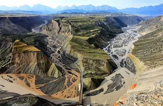 Anjihai Grand Canyon Viewing Area · 安集海大峡谷正规开放观景区
Anjihai Grand Canyon Viewing Area安集海大峡谷正规开放观景区
The Anjihai Grand Canyon (安集海大峡谷) is a deeply cut, multi-coloured river valley in the Anjihai River basin on the northern flank of the Tianshan, in Shawan City and Wusu City, Tacheng Prefecture, Xinjiang.
Read the place guide →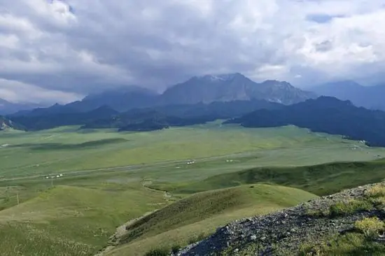 Lujiaowan Scenic Area · 鹿角湾
Lujiaowan Scenic Area鹿角湾
Lujiaowan (鹿角湾, 'Antler Bay') is a mountain grassland and scenic area at the foot of the Tianshan about seventy kilometres south-west of the Shawan urban area, in Shawan City, Tacheng Prefecture, Xinjiang.
Read the place guide →Plan your visit
Getting there
Shawan is about 335 km in a straight line from central Tacheng Prefecture. Search for 沙湾市 in a map app to find stations and your accommodation.
Where to stay →Build your route
Anjihai Grand Canyon Viewing Area and Lujiaowan Scenic Area are both listed here. The linked place guides have entrance and visit details.
Continue with Tacheng Prefecture →More in Tacheng Prefecture
Sources & geographic information
Administrative names and parent areas: Official geographic directory · Reference date 2026-09-06.
Photo: Anjihai Grand Canyon Viewing Area · Source photographer · License not provided. EXIF orientation normalized; resized without changing aspect ratio; converted to WebP. No subject edits.
Photo: Lujiaowan Scenic Area · Source photographer · License not provided. EXIF orientation normalized; resized without changing aspect ratio; converted to WebP. No subject edits.
Map data © OpenStreetMap contributors. Pins mark approximate centres, not entrances or boundaries.