


Get to know Mile

Photo adjustments
Full frame retained; proportionally resized and converted to WebP. No retouching or changes to the photographed subject. Card displays may crop the view.
- Administrative area
- County-level city · 县级市
- Part of
- Honghe Hani and Yi Autonomous Prefecture
- Chinese name
- 弥勒市
- Local areas
- County-level city guide
Area & population
- Area in the source
- 4,004.00 km²
- Population · 2021
- 570,100
Source: cited geographic source, as of the dates shown.
History
The name goes back to the Mile tribe (弥勒部). The History of Yuan (元史) records that Mile, a descendant of the Xiemotu people, took and settled the Guodian, Badian and Bulong areas, and his tribe was named after him; the later county took the tribe's name. In September 2025 Mile was added to Yunnan's third provincial list of place-name cultural heritage.
In 1952 the province replaced Mile County with a Mile Yi autonomous area, set up on 1 January 1953; it became Mile Yi Autonomous County in 1955. On 24 January 2013 the State Council approved turning the county into a county-level city.
What to see
Dongfengyun (东风韵), an arts town begun in 2014 in the south of the urban area and nicknamed the "Bordeaux of the East", is built of locally fired red brick. Its main group of buildings looks like wine bottles of different shapes up close and like flames from a distance, a reference to Mile's wine and to the fire traditions of the Yi. The main complex is laid out with a museum of the state farms (农垦博物馆). The Huquan ecological park (湖泉生态园) in the new town is a 4A-rated scenic area, and Taiping Lake forest park (太平湖森林公园) is a forest resort with log cabins.
Keyi (可邑) in Xisan town (西三镇) is a village of the Axi. The Mile city government describes painted folk murals on its walls, a heritage training hall and performances on the village square, and calls it a national model village for ethnic unity and progress.
Wine and Axi culture
The state-run Dongfeng farm (东风农场) is a centre of grape growing and produces the "Yunnan Red" (云南红) wine.
The Axi Moon Dance (阿细跳月), a Yi three-string dance, was added to the national intangible heritage list in 2008. It is danced to the big sanxian lute with bamboo flute, sanhu fiddle and moon guitar, and the tune is built mainly on three notes. Axi Xianji (阿细先基), which is sung, is also a national heritage item. Keyi works both into village life, and leaf-blowing, big-sanxian singing and embroidery are kept there as living traditions rather than static displays.
Highlights
- Dongfengyun 东风韵: Red-brick arts town begun in 2014, with buildings shaped like wine bottles and flames.
- Keyi 可邑小镇: Axi Yi village in Xisan town with a heritage training hall and performances.
- Axi Moon Dance 阿细跳月: National intangible heritage since 2008, danced to the big sanxian.
- Huquan ecological park 湖泉生态园: 4A-rated scenic area in the new town.
Sources for this guide
弥勒市 - 维基百科,自由的百科全书 · Wikipedia (Chinese) · CC BY-SA 4.0
弥勒可邑村:阿细文化绽放民族团结幸福花 · Mile Municipal People's Government
弥勒非遗丨弦声踏月伴此生:《彝族三弦舞(阿细跳月)》传承人段正荣的五十载弦歌 · Mile Municipal People's Government
Original English written from the listed sources and checked sentence by sentence against quoted extracts by a separate reviewer. Updated 2026-09-25.
Explore Mile
Core places to explore, with English and Chinese names.
Places to explore around Mile
 AI illustration · AI 示意图(仅供参考,非该地点实拍)
Dongfengyun Arts Complex东风韵
Dongfengyun ('East Wind Charm') is an arts-and-agritourism complex in Mile, Honghe Hani and Yi Autonomous Prefecture, Yunnan, built since 2014 around vineyards, lavender fields and contemporary art installations, and nicknamed 'the Provence of central Yunnan' by the municipal government.
Read the place guide →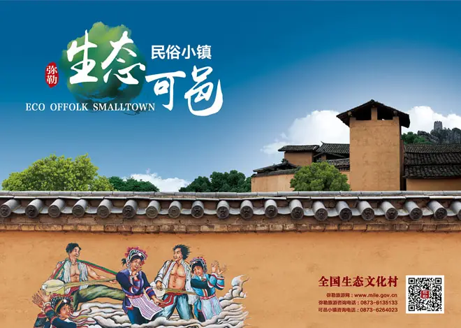 Keyi Town · 可邑小镇
Keyi Town可邑小镇
Keyi town (可邑小镇) is an Axi Yi settlement in northern Mile, Honghe Hani and Yi Autonomous Prefecture, Yunnan, recognised as a birthplace of the Axi Tiaoyue dance, a national intangible cultural heritage.
Read the place guide → The Longhua Pagoda on Jinping Hill (Jinping Mountain), overlooking the city of Mile · 弥勒市锦屏山景区龙华塔,俯瞰弥勒城区 Source-recorded photograph date: 2026-07-19 09:44:05.
Jinping Mountain锦屏山
Jinping Mountain (锦屏山) is a hill 10 kilometres north of Mile city, Honghe Hani and Yi Autonomous Prefecture, Yunnan, centred on the historic Mile Temple, with a large Maitreya Buddha statue at its core.
Read the place guide →Plan your visit
Getting there
Mile is about 115 km in a straight line from central Honghe Hani and Yi Autonomous Prefecture. Search for 弥勒市 in a map app to find stations and your accommodation.
Where to stay →Build your route
Dongfengyun Arts Complex and Keyi Town are both listed here. The linked place guides have entrance and visit details.
Continue with Honghe Hani and Yi Autonomous Prefecture →More in Honghe Hani and Yi Autonomous Prefecture
Sources & geographic information
Administrative names and parent areas: Official geographic directory · Reference date 2026-09-06.
Some facts checked against 弥勒市 — Wikipedia contributors, CC BY-SA 4.0.
Photo: Keyi Town · Source photographer · License not provided. EXIF orientation normalized; resized without changing aspect ratio; converted to WebP. No subject edits.
Photo: Jinping Mountain · User:CatOnMars · CC BY 4.0. Full frame retained; proportionally resized and converted to WebP. No retouching or changes to the photographed subject. Card displays may crop the view.

Map data © OpenStreetMap contributors. Pins mark approximate centres, not entrances or boundaries.