


Get to know Chenggong District
- Administrative area
- District · 市辖区
- Part of
- Kunming
- Chinese name
- 呈贡区
- Local areas
- District guide
Area & population
- Area
- 461.00 km²
- Population · 2023
- 709,700
Source: English Wikipedia, as of the dates shown.
Chenggong is not a compact old-town neighbourhood. It is Kunming’s eastern lakeside district, where the city’s newer civic and university areas meet flower-growing communities and the wetlands along Dianchi. That mix is the reason to come: a morning in a working flower market can lead to a slower afternoon beside the lake, while restored villages keep a local history that the new boulevards do not show. The municipal government places the district’s average annual temperature at 15.6°C and highlights its mild summer climate, but the landscape—not a generic “eternal spring” label—is the more useful way to understand Chenggong.
The district’s most recognisable public face is Dounan. Its flower market grew from local cultivation into a large cut-flower trading system: the market company describes an industrial park with trading, price information, research and horticultural-tourism functions, while Xinhua reported 2024 trading of 14.176 billion stems and an export network reaching 50 countries and regions. Chenggong therefore feels partly like a destination and partly like a place where other destinations’ bouquets are made, graded, auctioned and dispatched.
Dounan and the Dianchi east shore
At Dounan Flower Market (斗南花卉市场), look for the working rhythm rather than only a photo backdrop: growers and traders, cut stems sorted for different uses, retail displays and the logistics that move flowers beyond Yunnan. Public-facing market areas and auction or wholesale operations do not necessarily have identical access, so treat an auction hall as a working facility and follow on-site instructions. Flower-themed decorations and festivals are temporary; the 2024 “flower train” and Jingui Street station campaign was announced for one year, ending in 2025, and should not be assumed to be running now.
The lakeside is better understood as a chain of open-air stops than as one single attraction. Dounan Wetland Park, the Laoyu River banks and the greenway toward Jiangwei offer water, planted wetlands, fields and changing seasonal colour. The city’s English-language government guide specifically describes summer hydrangeas at Dounan Wetland Park, lotus in Jiangwei and camping by the Laoyu River; these are seasonal examples, not a promise of a particular flower display on every visit. A district tourism response describes the Dianchi greenway as linking Dounan, Jiangwei and Wolong, but its proposed sightseeing-bus route was still at the preliminary-plan stage in 2025. Do not build a day around that bus without checking its current operation.
Wolong Ancient Fishing Village
For a more historical walk, use the Chinese name 卧龙古渔村 (also associated with the former name 乌龙古渔村). The village lies below Qixing Mountain on the Dianchi shore and preserves a settlement shaped by fishing and ferry trade. Historical buildings from the Qing and Republican periods stand in connected groups; local government reporting counts 252 historic buildings, including 11 protected heritage buildings. The village’s old “Fishing Lights on Yupu” scene recalls boats that once arrived with goods and traders, while repaired wetlands, traditional courtyards and “yikeyin” houses make the relationship between water, farming and settlement visible. Treat it as a living village and heritage landscape: keep to public paths, respect residents and do not turn homes or working spaces into photo props.
The rest of Chenggong is a useful counterpoint. The district is promoted as both a “Spring City flower showcase” and a modern science-and-education innovation city, with the university cluster and the high-speed-rail hub shaping its everyday movement. That is why the district can feel urban around its civic centre and campuses, rural along the east-shore fields, and distinctly industrial at Dounan without those settings being separate towns.
Getting around
From central Kunming, Kunming Metro Line 4 is a practical rail spine toward Chenggong and Kunming South Railway Station. For Dounan, 2024 transport reporting identifies Jingui Street Station (金桂街站) and its B passage/exit as the direct approach to the market; the same report also lists Dounan Station (斗南站) on the line. A later report recorded a plan to rename Jingui Street Station “Dounan Flower Market Station”, so search for 金桂街站 Jīnguì Jiē Zhàn and 斗南花市站 Dǒunán Huāshì Zhàn and follow the current operator signage rather than relying on an old map label.
For Laoyuhe Wetland Park or Wolong Ancient Fishing Village, the last leg is more dependable by taxi or ride-hailing than by assuming a sightseeing service. Keep the Chinese destination names 捞渔河湿地公园 Lāoyúhé Shīdì Gōngyuán and 卧龙古渔村(乌龙村) ready, confirm the actual visitor-side entrance, and arrange the return before leaving the metro or railway corridor. The district’s own 2025 documents describe tourism-bus proposals and preliminary route planning, not a guaranteed daily service.
Guide sources
- Chenggong district: An ideal summer retreat
- Dounan International Flower Industry Park
- From flower fields and markets to a flower city
- Protecting and restoring an ancient fishing village
- Wolong Ancient Fishing Village renewed
- Kunming Metro Line 4 Dounan flower train
- Chenggong cultural-tourism bureau response on Dianchi greenway services
- Chenggong’s modern development path
- Flower train and Jingui Street flower-themed station
- Plan to rename Jingui Street Station
Explore Chenggong District
Core places to explore, with English and Chinese names.
Places to explore around Chenggong District
 The entrance façade of Dounan Flower Market in Kunming, with flower bundles and visitors outside the public market hall. Photo: 瑞丽江的河水 · CC BY-SA 4.0
Dounan Flower Market斗南花卉市场
Dounan Flower Market is Kunming’s working cut-flower trading complex in Chenggong District, where daytime retail, professional auctioning and evening wholesale turn Yunnan-grown flowers into a nationwide business. Its appeal is seeing the grading, packing, bargaining and logistics behind the bouquets, not just looking at a flower display.
Read the place guide → Laoyuhe Wetland Park's lakeside shore and tree-lined recreation area, with distant hills beyond the water. Photo: Kmahyyg · CC BY-SA 3.0
Laoyuhe Wetland Park捞渔河湿地公园
Laoyuhe is a restored wetland on the east bank of Lake Dian, where a water forest, a long boardwalk, birds and seasonal flowers make the lake edge worth exploring beyond Kunming’s central parks.
Read the place guide →Plan your visit
Getting there
Chenggong District is about 20 km (straight-line distance) from central Kunming. Search for 呈贡区 in a map app to find stations and your accommodation.
Where to stay →Build your route
Dounan Flower Market and Laoyuhe Wetland Park are about 9 km apart (straight-line distance). The linked place guides have entrance and visit details.
Continue with Kunming →More in Kunming
Sources & geographic information
Administrative names and parent areas: Official geographic directory (dmfw.mca.gov.cn) · Reference date 2026-09-06.
Background text adapted from Chenggong, Kunming — Wikipedia contributors, under CC BY-SA 4.0. Text has been shortened and reorganized; source revision 1353484552.
Map data © OpenStreetMap contributors. Pins mark approximate centres, not entrances or boundaries.
Image credits & notes (1)
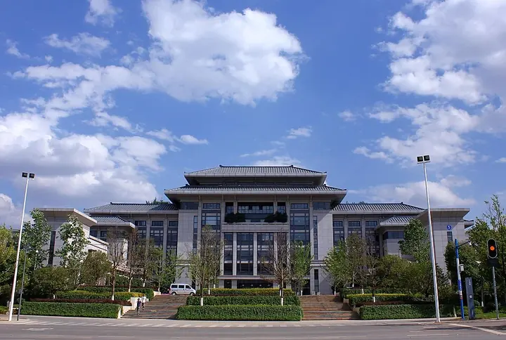
- Kunming City Hall in Chenggong District, Kunming. Photo: 2012-04-29.Photo: Zhangmoon618 · CC BY-SA 3.0Resized for the web; the photo itself has not been edited. Thumbnails may show a cropped view.
