


Get to know Xishan District

Photo adjustments
Full frame retained; proportionally resized and converted to WebP. No retouching or changes to the photographed subject. Card displays may crop the view.
- Administrative area
- District · 市辖区
- Part of
- Kunming
- Chinese name
- 西山区
- Local areas
- District guide
Area & population
- Area in the source
- 791.00 km²
- Population · 2020
- 960,746
Source: cited geographic source, as of the dates shown.
Setting and landscape
The district government counts 72 km of Lake Dian shoreline in Xishan, and 112 of its 881 square kilometres are lake water. Across the lake lies Chenggong (呈贡); Jinning (晋宁) is to the south and Anning (安宁) to the west. The land is high in the north-west and slopes gently down towards the lake. The highest point, 2,622 metres, is Fengbai Mountain (风摆山) in Tuanjie (团结), and the ranges include the Western Hills and Yu'an Mountain (玉案山). More than twenty rivers cross the district, most of them draining into Lake Dian or the Tanglang River (螳螂川).
What to see
Dragon Gate (西山龙门), at the far end of the Western Hills scenic area, is a 66.5-metre run of passages and grottoes cut into a sheer cliff. The Taoist Zhao Lian (赵炼) began it with a meditation cell around 1522; Wu Laiqing (吴来清) extended it between 1781 and 1795, and the Yang family finished the Datian Pavilion (达天阁) in 1853. Its 22 Taoist figures and 28 auspicious animals are all carved from the living rock.
Huating Temple (华亭寺), partway up Taihua Mountain (太华山), was founded in 1323 as Yuanjue Temple on the site of a villa of the Gao family of the Dali Kingdom, and received its present name in 1462. It is laid out in three parallel lines of courtyards with more than 200 rooms.
Daguan Tower (大观楼), also on the district's list of sights, was first built in 1690 and raised to three storeys in 1828. It was rebuilt in 1864 and again in 1883, when a noted scholar wrote out Sun Ran's (孙髯翁) long couplet afresh to be carved and hung. The three-storey tower is 18 metres tall and, apart from the ground-floor walls, built of timber.
History
Xishan became a city district in October 1956. In the south, Haikou (海口) is described by Chinese Wikipedia as a birthplace of Yunnan industry: China's first machine gun was made at Arsenal No. 51 there in June 1941, and the Shilongba Hydropower Station (石龙坝水电站) was China's first hydroelectric plant.
Highlights
- Dragon Gate 西山龙门: Cliff-cut passage and grottoes carved between about 1522 and 1853.
- Huating Temple 华亭寺: Founded in 1323 on the site of a Dali Kingdom villa; named Huating in 1462.
- Daguan Tower 大观楼: Three-storey tower first built in 1690, hung with Sun Ran's long couplet.
- Shilongba Hydropower Station 石龙坝水电站: China's first hydroelectric station, at Haikou.
Sources for this guide
西山概况-西山概况-昆明市西山区人民政府 · Xishan District People's Government, Kunming
西山龙门-景点荟萃-昆明市西山区人民政府 · Xishan District Culture and Tourism Bureau, Kunming
华亭寺-景点荟萃-昆明市西山区人民政府 · Xishan District Culture and Tourism Bureau, Kunming
大观楼(简介)-景点荟萃-昆明市西山区人民政府 · Xishan District Culture and Tourism Bureau, Kunming
西山区 - 维基百科,自由的百科全书 · Chinese Wikipedia · CC BY-SA 4.0
Original English written from the listed sources and checked sentence by sentence against quoted extracts by a separate reviewer. Updated 2026-09-25.
Explore Xishan District
Core places to explore, with English and Chinese names.
Places to explore around Xishan District
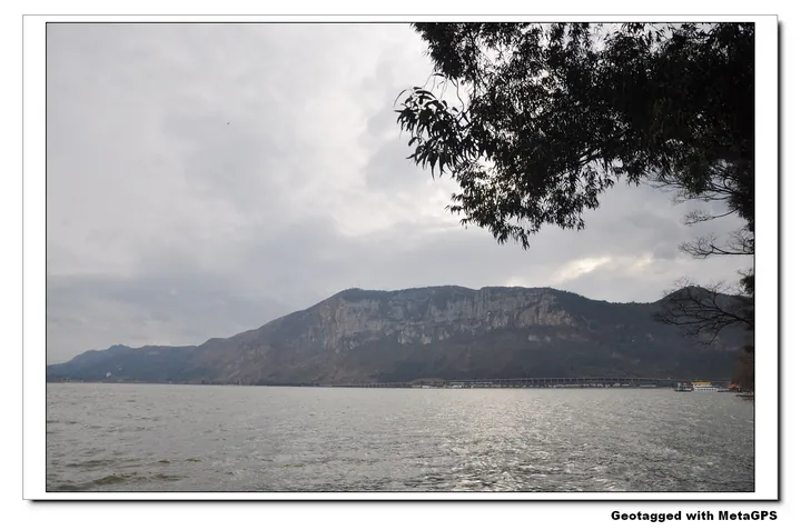 Dianchi Lake and the lakeside escarpment seen from Haigeng, Xishan District, Kunming · 昆明市西山区滇池海埂湖景,远处可见湖畔山崖 Source-recorded photograph date: 2013-01-30 17:27.
Dianchi Lake Haigeng Park滇池海埂
Haigeng is the dyke and lakefront park on the east shore of Lake Dian in Xishan District, Kunming, where a long embankment reaches into the lake, dividing it into two bodies of water, looking across to the Xishan scenic area.
Read the place guide →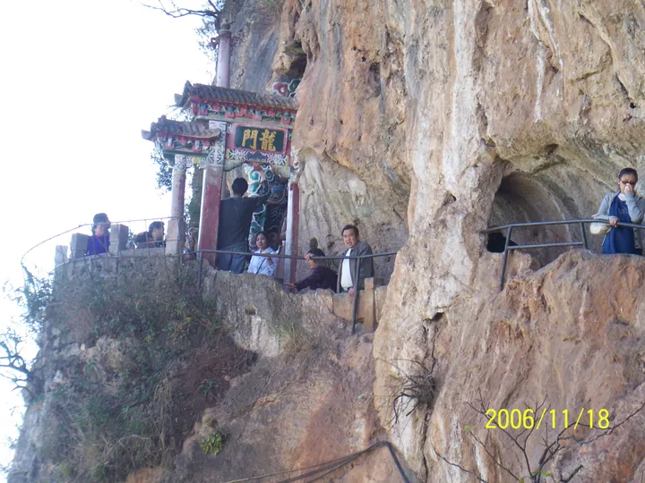 Visitors at the rock-carved Dragon Gate (Longmen) archway, Xishan, Kunming · 昆明西山龙门石刻牌坊,游人穿行其间 Source-recorded photograph date: Taken on 18 November 2006.
Western Hills Dragon Gate西山龙门
Daoist grottoes and a stone gateway carved into Kunming's Western Hills cliff 414 m above Dianchi Lake, mostly between 1781 and 1853.
Read the place guide → The main entrance archway of the Yunnan Nationalities Village, Xishan District, Kunming · 昆明市西山区云南民族村大门牌坊 Source-recorded photograph date: Taken on 14 May 2014.
Yunnan Ethnic Village云南民族村
Theme park by Dianchi Lake below Kunming's Western Hills, opened in 1992, with village compounds and festivals of Yunnan's ethnic groups.
Read the place guide →Plan your visit
Getting there
Xishan District is about 5 km in a straight line from central Kunming. Search for 西山区 in a map app to find stations and your accommodation.
Where to stay →Build your route
Dianchi Lake Haigeng Park and Western Hills Dragon Gate are both listed here. The linked place guides have entrance and visit details.
Continue with Kunming →More in Kunming
Sources & geographic information
Administrative names and parent areas: Official geographic directory · Reference date 2026-09-06.
Some facts checked against 西山区 — Wikipedia contributors, CC BY-SA 4.0.
Photo: Dianchi Lake Haigeng Park · drnan tu from Shenzhen, China · CC BY-SA 2.0. Full frame retained; proportionally resized and converted to WebP. No retouching or changes to the photographed subject. Card displays may crop the view.
.jpg)
Photo: Western Hills Dragon Gate · hilloo · CC BY-SA 3.0. Full frame retained; proportionally resized and converted to WebP. No retouching or changes to the photographed subject. Card displays may crop the view.

Photo: Yunnan Ethnic Village · ping lin · CC BY-SA 3.0. Full frame retained; proportionally resized and converted to WebP. No retouching or changes to the photographed subject. Card displays may crop the view.
.jpg)
Map data © OpenStreetMap contributors. Pins mark approximate centres, not entrances or boundaries.