


Get to know Cangyuan Va Autonomous County

Photo adjustments
Full frame retained; proportionally resized and converted to WebP. No retouching or changes to the photographed subject. Card displays may crop the view.
- Administrative area
- Autonomous county · 自治县
- Part of
- Lincang
- Chinese name
- 沧源佤族自治县
- Local areas
- Autonomous county guide
Area & population
- Area in the source
- 2,539.00 km²
- Population · 2020 census
- 160,262
- Administrative seat
- Mengdong
Source: cited geographic source, as of the dates shown.
Setting and landscape
The county lies at the southern end of the Hengduan mountains' long valleys in western Yunnan. Deeply cut mid-height mountains alternate with river valleys, and mountain land covers 99.2 percent of the area; the small basins of Mengjiao (勐角), Mengdong (勐董) and Mengsheng (勐省) make up the rest. The highest point is Wokan Mountain (窝坎大山) at 2,605 m, and the lowest, 450 m, is where the Nanting River (南汀河) leaves the county at Mangka (芒卡).
History
The area was long known as the Awa Mountains (阿佤山区) or "land of the Gourd King" (葫芦王地). The National Ethnic Affairs Commission notes that Cangyuan's Va read the name of their origin myth, Sigangli (司岗里), as people "coming out of a gourd". Mengdong became the seat of the Cangyuan administrative bureau in 1937. In 1934 Va people at Banhong (班洪) resisted a British armed occupation of silver mines in the Banhong and Banlao (班老) tribal lands, and under the 1960 China-Burma boundary treaty the Banhong and Banlao tribal area passed to China.
What to see
The Cangyuan cliff paintings (沧源崖画) are 17 Neolithic rock-painting sites, a national key protected site since 2001. First recorded in January 1965, they are painted in red haematite on limestone cliffs at 1,200–2,000 m, apparently with fingers; uranium-series dating in 2020 put them at 3,800 to 2,700 years old. Guangyun Temple (广允缅寺) in Mengdong town, a Theravada Buddhist temple with a Qing-dynasty hall, has ten murals of Jataka tales and a chieftain's procession and was listed nationally in 1988. Wengding (翁丁村) in Mengjiao township, known as a Va settlement, has thatched stilt houses with living space above and pens for pigs and cattle below; its old village burned on 14 February 2021 and reopened after rebuilding on 28 December 2022. China Energy News names the Banhong Gourd King Land (班洪葫芦王地) as a national 4A scenic area.
Getting oriented
The county seat is Mengdong town. Cangyuan Washan Airport (沧源佤山机场) opened on 8 December 2016, 36 km north of the county town. The Cangyuan border port is a second-class national land port with three crossings into Myanmar. The Cangyuan section of the Ruili-Menglian expressway (瑞孟高速) opened to trial traffic on 13 February 2026.
Highlights
- Cangyuan cliff paintings 沧源崖画: 17 Neolithic red haematite rock-painting sites, dated to 3,800-2,700 years ago; national key protected site since 2001.
- Guangyun Temple 广允缅寺: Theravada temple with a Qing-dynasty hall and ten murals; national key protected site since 1988.
- Wengding village 翁丁村: Va village of thatched stilt houses, rebuilt after the 2021 fire.
- Banhong Gourd King Land 班洪葫芦王地: National 4A scenic area.
Sources for this guide
沧源佤族自治县 - 维基百科,自由的百科全书 · Chinese Wikipedia · CC BY-SA 4.0
沧源崖画 - 维基百科,自由的百科全书 · Chinese Wikipedia · CC BY-SA 4.0
广允缅寺 - 维基百科,自由的百科全书 · Chinese Wikipedia · CC BY-SA 4.0
翁丁村 - 维基百科,自由的百科全书 · Chinese Wikipedia · CC BY-SA 4.0
打造边疆智能配网示范 助力佤山和美乡村建设 · China Energy News (People's Daily)
历史沿革 · National Ethnic Affairs Commission
Original English written from the listed sources and checked sentence by sentence against quoted extracts by a separate reviewer. Updated 2026-09-25.
Explore Cangyuan Va Autonomous County
Core places to explore, with English and Chinese names.
Places to explore around Cangyuan Va Autonomous County
Rock face at Cangyuan cliff-painting site No. 1 · 沧源崖画 Photograph date recorded by the source: 15 October 2024, 14:55:01.Cangyuan Cliff Paintings沧源崖画
The Cangyuan rock paintings are spread across limestone cliffs in the Xiaohei River valley system. Red mineral pigment forms small human figures, animals and other symbols, with scenes interpreted as hunting, gathering, dancing…
Read the place guide →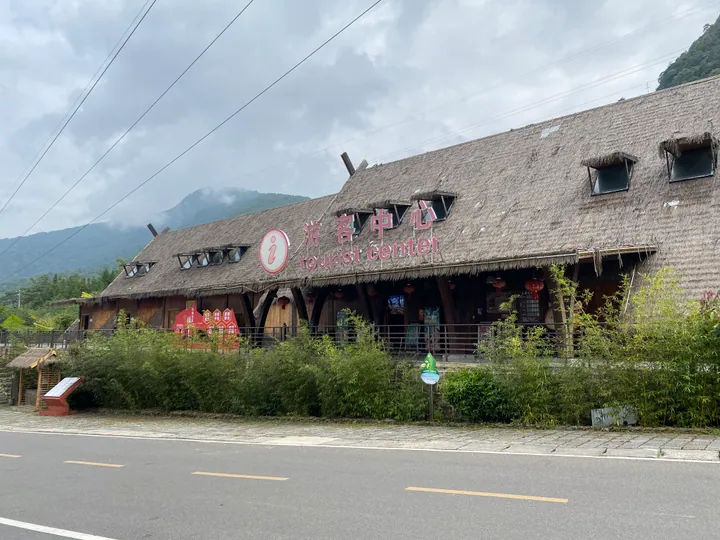 The visitor centre building at Om Din (Weng Ding) Village primitive tribal culture tourism area, Cangyuan · 沧源佤族自治县翁丁原始部落文化旅游区游客中心 Source-recorded photograph date: 2024-10-15 10:44:14.
Wengding Va Tribal Culture Scenic Area翁丁原始部落文化旅游区
Weng Ding (翁丁), in Cangyuan Va Autonomous County, Lincang, is a Va village whose old settlement — once one of Yunnan's most completely preserved examples of traditional Va architecture — was destroyed by fire in 2021 and rebuilt on its original site.
Read the place guide →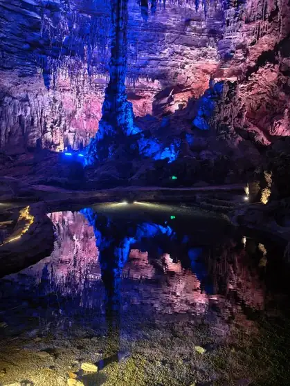 Sigangli Cave · 司岗里溶洞
Sigangli Cave司岗里溶洞
Sigangli Cave (司岗里溶洞) is a limestone cave in Cangyuan Va Autonomous County, Lincang, Yunnan, forming part of the Sigangli Rock Painting Gorge scenic area near the Menglai Grand Canyon.
Read the place guide →Plan your visit
Getting there
Cangyuan Va Autonomous County is about 105 km in a straight line from central Lincang. Search for 沧源佤族自治县 in a map app to find stations and your accommodation.
Where to stay →Build your route
Cangyuan Cliff Paintings and Wengding Va Tribal Culture Scenic Area are both listed here. The linked place guides have entrance and visit details.
Continue with Lincang →More in Lincang
Sources & geographic information
Administrative names and parent areas: Official geographic directory · Reference date 2026-09-06.
Some facts checked against 沧源佤族自治县 — Wikipedia contributors, CC BY-SA 4.0.
Some facts checked against 沧源崖画 — Wikipedia contributors, CC BY-SA 4.0.
Some facts checked against 广允缅寺 — Wikipedia contributors, CC BY-SA 4.0.
Some facts checked against 翁丁村 — Wikipedia contributors, CC BY-SA 4.0.
Photo: Cangyuan Cliff Paintings · 瑞丽江的河水 · CC BY-SA 4.0. Full frame retained; proportionally resized and converted to WebP. No retouching or changes to the photographed subject. Card displays may crop the view.

Photo: Wengding Va Tribal Culture Scenic Area · 瑞丽江的河水 · CC BY-SA 4.0. Full frame retained; proportionally resized and converted to WebP. No retouching or changes to the photographed subject. Card displays may crop the view.

Photo: Sigangli Cave · Source photographer · License not provided. EXIF orientation normalized; resized without changing aspect ratio; converted to WebP. No subject edits.
Map data © OpenStreetMap contributors. Pins mark approximate centres, not entrances or boundaries.