


Get to know Tiantai County
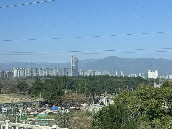
Photo adjustments
Full frame retained; resized proportionally to a maximum dimension of 960 pixels and converted to WebP quality 88. No crop, retouch, generated elements, or subject alteration. Final website rendition: full frame retained, proportionally resized to at most 720 pixels and converted to WebP. No additional retouching or subject alteration. Card displays may crop the view.
- Administrative area
- County · 县
- Part of
- Taizhou
- Chinese name
- 天台县
- Local areas
- County guide
Area & population
- Area in the source
- 1,431.66 km²
- Population · 2020
- 474,711
Source: cited geographic source, as of the dates shown.
Setting and landscape
The county is a basin with mountains on all four sides and a river-valley plain in the middle. The Shifeng River (始丰溪), also called the Daxi (大溪), is the longest stream in the county and runs through the basin before leaving for Linhai (临海). Mount Tiantai forms the watershed between the Yong (甬江), Cao'e (曹娥江) and Ling (灵江) rivers and is known for its cliffs and waterfalls; its main peak, Huading (华顶山), rises north-east of the county town and is made of granite.
History
A county called Shiping (始平县) was carved out of Zhang'an between 222 and 231 under the Wu kingdom, and this marks the start of Tiantai as a county. The name Tiantai was first used in 908 and, after several changes, was fixed in 960 under the Song; it has been kept ever since.
What to see
Guoqing Temple (国清寺), north of the old county town, is the birthplace of the Tiantai school, the first Buddhist school founded in China. It was begun in 598 under the Sui and named a national protected site in 2001. Its Sui pagoda was rebuilt in 1129.
The Shiliang waterfall (石梁飞瀑) lies in the Shiqiao hills 14.5 kilometres north-east of the county town. Two streams form a group of falls below Zhanfeng Bridge (瞻风桥), pass through a stone beam in three stages and drop over a cliff more than 30 metres high into a deep pool. More than 20 inscriptions from the Song and Ming onward are carved above and below the beam, and nearby is a carving of the words "First Wonder" (第一奇观) written by the Song calligrapher Mi Fu (米芾).
Food and local products
Tiantai dry-lacquer with ramie (天台山干漆夹苎技艺), on the national intangible-heritage list since 2006, is a 48-step craft used mainly for Buddhist statues; the list records its use in Tiantai since the Eastern Jin. The Tiantai Yijin Jing (天台山易筋经), a set of Taoist stretching and breathing exercises passed down among the Taoists of Tongbai Palace (桐柏宫) since the Ming, joined the national list in 2021.
Highlights
- Guoqing Temple 国清寺: Birthplace of the Tiantai school, begun in 598; national protected site since 2001.
- Shiliang waterfall 石梁飞瀑: Waterfall through a stone beam, more than 30 m high, with carved inscriptions.
- Mount Tiantai 天台山: Range dividing the Yong, Cao'e and Ling rivers; birthplace of Tiantai Buddhism.
- Tiantai dry-lacquer craft 天台山干漆夹苎技艺: National intangible heritage: 48-step lacquer-and-ramie technique for statues.
Sources for this guide
天台山干漆夹苎技艺 - 中国非物质文化遗产网 · China Intangible Cultural Heritage Network (Ministry of Culture and Tourism)
易筋经(天台山易筋经) - 中国非物质文化遗产网 · China Intangible Cultural Heritage Network (Ministry of Culture and Tourism)
天台县 - 维基百科,自由的百科全书 · Wikipedia (Chinese) · CC BY-SA 4.0
天台山 - 维基百科,自由的百科全书 · Wikipedia (Chinese) · CC BY-SA 4.0
石梁飞瀑 - 维基百科,自由的百科全书 · Wikipedia (Chinese) · CC BY-SA 4.0
Original English written from the listed sources and checked sentence by sentence against quoted extracts by a separate reviewer. Updated 2026-09-25.
Explore Tiantai County
Core places to explore, with English and Chinese names.
Places to explore around Tiantai County
 A hall at Guoqing Temple on Tiantai Mountain · 国清寺 Photograph date recorded by the source: 27 December 2014, 12:36:36.
Guoqing Temple国清寺
Guoqing Temple stands at the foot of Tiantai Mountain and is closely associated with the Tiantai Buddhist tradition and its Japanese Tendai connections. Its present halls reflect repeated rebuilding and restoration, while the…
Read the place guide → Shiliang Waterfall · 石梁飞瀑
Shiliang Waterfall石梁飞瀑
Waterfall in Tiantai, Zhejiang, pouring beneath a natural stone beam, with old cliff inscriptions and temples linked to the Five Hundred Arhats.
Read the place guide → AI illustration · AI 示意图(仅供参考,非该地点实拍)
Tiantai Mountain Great Waterfall天台山大瀑布
Tiantai Mountain's Great Waterfall is a restored nine-stage cascade on the western slopes of Tongbai Mountain, where a diversion system returned water to a historic waterfall landscape.
Read the place guide →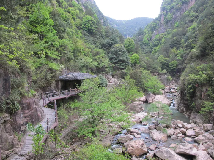 A wooden walkway and pavilion beside the stream in Qiongtai Xiangu scenic gorge, Tiantai County, Taizhou · 台州市天台县琼台仙谷景区中的溪流栈道与亭阁 Source-recorded photograph date: Taken on 6 April 2013.
Qiongtai Fairy Valley琼台仙谷
Qiongtai Xiangu in Tiantai is a steep granite valley where Baxian Lake, cliffside paths and waterfalls create a sequence of enclosed mountain views.
Read the place guide →Plan your visit
Getting there
Tiantai County is about 70 km in a straight line from central Taizhou. Search for 天台县 in a map app to find stations and your accommodation.
Where to stay →Build your route
Guoqing Temple and Shiliang Waterfall are both listed here. The linked place guides have entrance and visit details.
Continue with Taizhou →More in Taizhou
Sources & geographic information
Administrative names and parent areas: Official geographic directory · Reference date 2026-09-06.
Some facts checked against 天台县 — Wikipedia contributors, CC BY-SA 4.0.
Some facts checked against 天台山 — Wikipedia contributors, CC BY-SA 4.0.
Some facts checked against 石梁飞瀑 — Wikipedia contributors, CC BY-SA 4.0.
Photo: Guoqing Temple · Siyuwj · CC BY-SA 4.0. Full frame retained; proportionally resized and converted to WebP. No retouching or changes to the photographed subject. Card displays may crop the view.

Photo: Shiliang Waterfall · Source photographer · License not provided. EXIF orientation normalized; resized without changing aspect ratio; converted to WebP. No subject edits.
Photo: Qiongtai Fairy Valley · 江上清风1961 · CC BY 3.0. Full frame retained; proportionally resized and converted to WebP. No retouching or changes to the photographed subject. Card displays may crop the view.
.jpg)
Map data © OpenStreetMap contributors. Pins mark approximate centres, not entrances or boundaries.