


Get to know Changde

Photo adjustments
Full frame retained; proportionally resized and converted to WebP. No retouching or changes to the photographed subject. Card displays may crop the view.
- Administrative area
- Prefecture-level city · 地级市
- Part of
- Hunan
- Chinese name
- 常德市
- Local areas
- 9 local areas
Area & population
- Area in the source
- 18,177.00 km²
- Population · 2020 census
- 5,279,102
- Administrative seat
- Wuling District
Source: cited geographic source, as of the dates shown.
The area has been inhabited by humans since around 8,000 years ago. In that time, the city has changed names several times, but it has been known as Changde since the 12th century. The city is well known for the Battle of Changde during the Second Sino-Japanese War (1937–45) and the atrocities committed then by the Imperial Japanese Army.
Changde Uyghur culture
Taoyuan county's Uyghur community is culturally distinct from the Uyghur communities of Xinjiang. While Islam plays a central role in Xinjiang Uyghur culture, Islam and religious orthodoxy are much less prominent in Changde Uyghur culture. In particular, young Changde Uyghurs often do not practice Islam and consume pork, strictly forbidden among Xinjiang Uyghurs and Muslims in general, but common for the Han Chinese. In addition, the Changde Uyghurs speak Chinese instead of Uyghur. Those who practice Islam also learn Arabic for religious purposes.
Explore Changde
Core places to explore, with English and Chinese names.
Huping Mountain 壶瓶山
Changde Taohuayuan 常德桃花源旅游区
Peach Blossom Land 桃花源
Changde Museum 常德博物馆
Changde Poetry Wall and Yuan River Waterfront 常德诗墙与沅江岸线
West Dongting Lake Birdwatching Area 西洞庭湖开放观鸟区
Chengtoushan Neolithic Site 城头山
Hupingshan Scenic Area 壶瓶山开放景区
Jiashan Temple 夹山寺
Wuling District 武陵区
Dingcheng District 鼎城区
Anxiang County 安乡县
Hanshou County 汉寿县
Lixian 澧县
Linli County 临澧县
Taoyuan County 桃源县
Shimen County 石门县
Jinshi 津市市
Places to explore around Changde
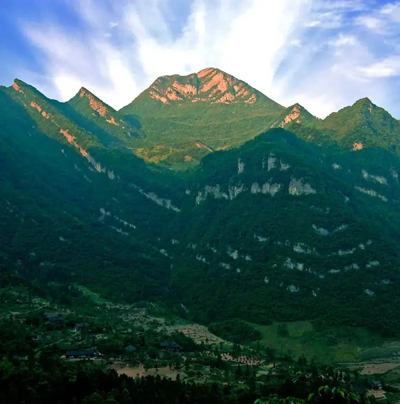 Huping Mountain · 壶瓶山
Huping Mountain壶瓶山
Huping Mountain is a forested border landscape in Shimen County, with deep stream valleys and important wildlife habitat. Its interest lies in the relationship between protected forest, waterfalls and surrounding tea-growing…
Read the place guide → Changde Taohuayuan (常德桃花源旅游区), Taoyuan County. Photograph: "The peach garden 1".
Changde Taohuayuan常德桃花源旅游区
Taohuayuan in Taoyuan County interprets the pastoral world associated with Tao Yuanming's Peach Blossom Spring.
Read the place guide →Peach Blossom Land (桃花源), Taoyuan County. Photograph: "The peach garden 1".Peach Blossom Land桃花源
Taohuayuan (桃花源) is a hillside complex of temples, pavilions, bridges and steles in Shuixi Town, Taoyuan County, Changde, on the lower reaches of the Yuan River. It is the place conventionally identified with the refuge described in Tao Yuanming's Record of the Peach Blossom Spring, and its buildings are protected as a national cultural relics protection unit.
Read the place guide → Exterior view of the Changde Museum building, Wuling District, Changde · 湖南省常德市武陵区常德博物馆建筑外观 Source-recorded photograph date: 2024-02-28 16:56:17.
Changde Museum常德博物馆
Changde Museum (常德博物馆) is the municipal museum of Changde in Wuling District, Hunan, founded in 1990 as a comprehensive regional museum for the northwest of the province and as the city's centre for collecting, researching and conserving cultural relics.
Read the place guide →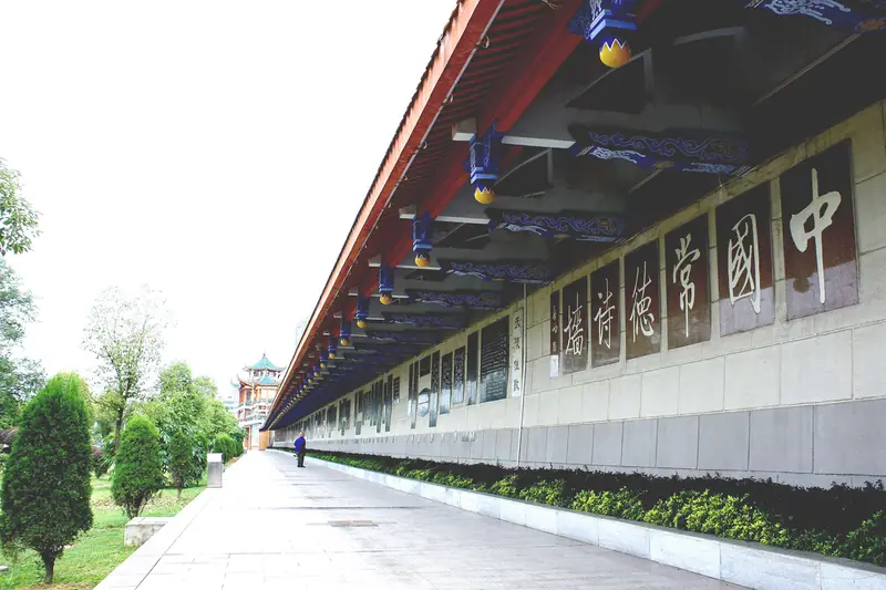 Changde Poetry Wall and Yuan River Waterfront · 常德诗墙与沅江岸线
Changde Poetry Wall and Yuan River Waterfront常德诗墙与沅江岸线
The Changde Poetry Wall (常德诗墙) is a continuous run of carved poetry, calligraphy and relief pictures set into the concrete flood-defence wall along the Yuan River in Wuling District, Changde, Hunan. The park along the embankment is open to the public, and the city treats it as its principal attraction for receiving visitors.
Read the place guide →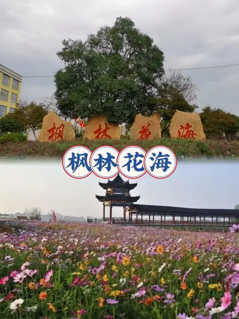 West Dongting Lake Birdwatching Area · 西洞庭湖开放观鸟区
West Dongting Lake Birdwatching Area西洞庭湖开放观鸟区
The birdwatching area known in the catalogue as 西洞庭湖开放观鸟区 refers to the visitor-facing part of the West Dongting Lake National Nature Reserve in Hanshou County, Changde, Hunan, a wetland reserve on the western arm of Dongting Lake. Most of the reserve is protected habitat; the public birdwatching point is the Qingshan Lake migratory bird garden.
Read the place guide →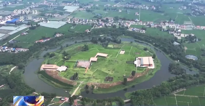 Chengtoushan Neolithic Site · 城头山
Chengtoushan Neolithic Site城头山
Chengtoushan (城头山) is an excavated Neolithic walled settlement at Nanyue village in Chexi township, Lixian County, Changde, Hunan. It is ringed by a circular rampart and a moat, and paddy fields dated to about 6,500 years ago were excavated inside the walled area.
Read the place guide → AI illustration · AI 示意图(仅供参考,非该地点实拍)
Hupingshan Scenic Area壶瓶山开放景区
Hupingshan (壶瓶山) is a mountain in Shimen County, Changde, Hunan, at the northeastern end of the Wuling range; its main peak reaches 2,098.7 m, and the provincial government's account records that it is known as the roof of Hunan. Most of the massif lies inside a national nature reserve; the sections open to visitors are gorges and an old tea town on its lower slopes.
Read the place guide →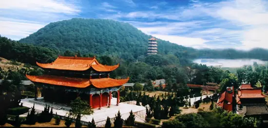 Jiashan Temple · 夹山寺
Jiashan Temple夹山寺
Chan monastery in Shimen County, Hunan, founded in 870, where Yuanwu Keqin, author of the Blue Cliff Record, lectured; national heritage site since 2013.
Read the place guide →Local life & food
Changde local specialties
常德市特色美食 · 11 specialties to discover
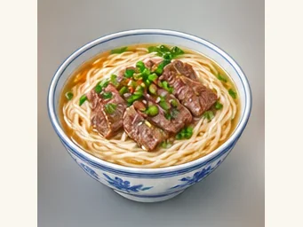 Changde rice noodles 常德米粉AI illustration · AI 示意图
The strands are smooth and resilient, carrying the broth without a wheat flavor. Beef, pork or other toppings change both richness and seasoning.
Source ↗Read the dish guide →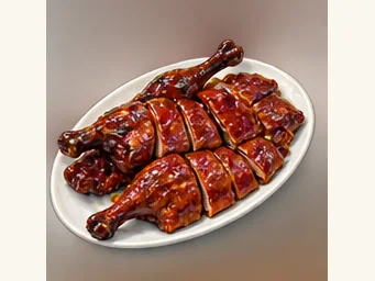 Changde spiced pressed duck 常德酱板鸭AI illustration · AI 示意图
The meat is firm and chewy with a salty, persistent spice finish, quite different from soft poached duck.
Source ↗Read the dish guide → Changde Beef Rice Noodles 常德牛肉米粉Reference photo of a similar dish · 同类菜品参考照片
Changde Beef Rice Noodles (常德牛肉米粉) are rice noodles in a hot broth topped with beef, from Changde (常德) in Hunan.
Read the dish guide →
Photo adjustments
Full frame retained; EXIF orientation normalized, proportionally resized to at most 800 pixels and converted to WebP. No generated pixels or subject changes. Cards may crop the display.
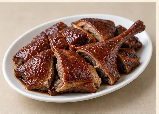 Spiced Pressed Duck 酱板鸭AI dish illustration / AI 菜品示意图 — not a restaurant photograph
Flattened duck roasted and then braised with soy and spices; this illustration follows the documented Changde version of jiangban ya.
Source ↗Read the dish guide → Taoyuan Pounded Tea 桃源擂茶AI illustration · AI 示意图(仅供参考,非实拍)
Taoyuan Pounded Tea (桃源擂茶) is the pounded tea of Taoyuan County (桃源县) in Changde (常德), known on the Changde government portal as Taohuayuan pounded tea (桃花源擂茶) after the Peach Blossom Land (桃花源) area.
Read the dish guide → Jinshi Beef Rice Noodles 津市牛肉粉AI dish illustration / AI 菜品示意图 — not a restaurant photograph
Jinshi's slender round rice noodles are scalded and served with a chosen beef topping; this illustration uses red-braised beef.
Source ↗Read the dish guide → Shimen Pork Intestines 石门肥肠AI illustration · AI 示意图(仅供参考,非实拍)
Shimen Pork Intestines (石门肥肠) is a dish of pork large intestine that is boiled, then stir-fried with chilli and finished in a pot kept hot at the table.
Read the dish guide →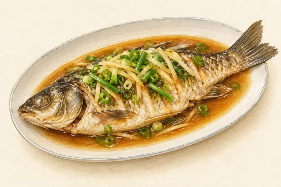 Linli Huanghua Fish 临澧黄花鱼AI illustration · AI 示意图(仅供参考,非实拍)
Linli Huanghua Fish (临澧黄花鱼) is a fish from Linli County (临澧县) in Changde (常德), Hunan, protected as a national geographical-indication product since 2013.
Read the dish guide →All dish names · 全部菜名 (11)
- Changde rice noodles · 常德米粉
- Changde spiced pressed duck · 常德酱板鸭
- Changde Beef Rice Noodles · 常德牛肉米粉
- Spiced Pressed Duck · 酱板鸭
- Taoyuan Pounded Tea · 桃源擂茶
- Jinshi Beef Rice Noodles · 津市牛肉粉
- Shimen Pork Intestines · 石门肥肠
- Linli Huanghua Fish · 临澧黄花鱼
- Hanshou Soft-Shelled Turtle · 汉寿甲鱼
- Dingcheng Numbing-Spicy Pork · 鼎城麻辣肉
- Bozi Tabletop Pot Dishes · 钵子菜
More dishes from across Hunan are in the Hunan food guide.
Counties & districts in Changde
9 areas belong directly to Changde.
9 areas
Wuling District 武陵区
Wuling District (simplified Chinese: 武陵区; traditional Chinese: 武陵區; pinyin: Wǔlíng Qū) is one of two urban districts in Changde City, Hunan Province, China.
Explore the area →DistrictDingcheng District 鼎城区
Dingcheng District (simplified Chinese: 鼎城区; traditional Chinese: 鼎城區; pinyin: Dǐngchéng Qū) is one of two urban districts in Changde City, Hunan Province, China; it is also the 2nd most populous district…
Explore the area →CountyAnxiang County 安乡县
Anxiang County (simplified Chinese: 安乡县; traditional Chinese: 安鄉縣; pinyin: Ānxiāng Xiàn) is a county in Hunan Province, China, under the administration of the prefecture-level city of Changde.
Explore the area →CountyHanshou County 汉寿县
Hanshou County (simplified Chinese: 汉寿县; traditional Chinese: 漢壽縣; pinyin: Hànshòu Xiàn) is a county in Hunan Province, China, under the administration of Changde prefecture-city.
Explore the area →Show fewer areas
Lixian 澧县
Li County, or Lixian (simplified Chinese: 澧县; traditional Chinese: 澧縣; pinyin: Lǐ Xiàn) is a county in Hunan Province, China, under the administration of the prefecture-level city of Changde.
Explore the area →CountyLinli County 临澧县
Linli (simplified Chinese: 临澧县; traditional Chinese: 臨澧縣; pinyin: Línlǐ Xiàn) is a county in Hunan Province, China. It is under the administration of the prefecture-level city of Changde.
Explore the area →CountyTaoyuan County 桃源县
Taoyuan County (simplified Chinese: 桃源县; traditional Chinese: 桃源縣; pinyin: Táoyuán Xiàn) is under the administration of Changde, Hunan Province, China.
Explore the area →CountyShimen County 石门县
Shimen County (simplified Chinese: 石门县; traditional Chinese: 石門縣; pinyin: Shímén Xiàn) is the northernmost county of Hunan Province, China, bordering Hubei Province to the north.
Explore the area →County-level cityJinshi 津市市
Jinshi City is a county-level city in Hunan Province, China, under the administration of the prefecture-level city of Changde.
Explore the area →No areas match this name.
Plan your visit
Getting there
Search for 常德市 in a map app to find stations and your accommodation.
Where to stay →Build your route
Huping Mountain and Changde Taohuayuan are both listed here. The linked place guides have entrance and visit details.
Continue with Hunan →More in Hunan
Sources & geographic information
Administrative names and parent areas: Official geographic directory · Reference date 2026-09-06.
Background text adapted from Changde — Wikipedia contributors, under CC BY-SA 4.0. Text has been shortened and reorganized; source revision 1359605851.
Photo: Huping Mountain · Source photographer · License not provided. EXIF orientation normalized; resized without changing aspect ratio; converted to WebP. No subject edits.
Photo: Changde Taohuayuan · Huangdan2060 · Public domain. Full frame retained; EXIF orientation normalized, proportionally resized to at most 800 pixels and converted to WebP. No generated pixels or subject changes. Cards may crop the display.

Photo: Peach Blossom Land · Huangdan2060 · Public domain. Full frame retained; EXIF orientation normalized, proportionally resized to at most 800 pixels and converted to WebP. No generated pixels or subject changes. Cards may crop the display.
Photo: Changde Museum · Uuongkinghe · CC BY-SA 4.0. Full frame retained; proportionally resized and converted to WebP. No retouching or changes to the photographed subject. Card displays may crop the view.

Photo: Changde Poetry Wall and Yuan River Waterfront · Source photographer · License not provided. EXIF orientation normalized; resized without changing aspect ratio; converted to WebP. No subject edits.
Photo: West Dongting Lake Birdwatching Area · Source photographer · License not provided. EXIF orientation normalized; resized without changing aspect ratio; converted to WebP. No subject edits.
Photo: Chengtoushan Neolithic Site · Source photographer · License not provided. EXIF orientation normalized; resized without changing aspect ratio; converted to WebP. No subject edits.
Photo: Jiashan Temple · Source photographer · License not provided. EXIF orientation normalized; resized without changing aspect ratio; converted to WebP. No subject edits.
Map data © OpenStreetMap contributors. Pins mark approximate centres, not entrances or boundaries.