


Get to know Nantou County
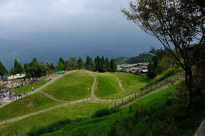
Photo adjustments
Full-frame source proportionally resized and converted to WebP for display. No subject alteration. Source-supplied marks and edits remain; cards may crop the view.
- Administrative area
- County / city · 縣市
- Part of
- Taiwan
- Chinese name
- 南投縣
- Local areas
- 13 local areas
Area & population
- Area in the source
- 4,106.44 km²
- Administrative seat
- Nantou City
Source: cited geographic source, as of the dates shown.
What is now Nantou supported a number of indigenous groups that retained autonomy from the central government during the Qing rule of the island. Settlement was initially banned, but in the late 19th century, it was encouraged. Many Hoklo and Hakka people moved in during this period. Under Japanese rule, the area was brought fully under government control, a sometimes violent process that shaped local ethnic identities. The region began to industrialize while also seeing increased agricultural production. Following the retrocession of Taiwan, Nantou County was separated from Taichung County. In the late 20th century, the area saw an increase in tourism, which has become a prominent part of the local economy. Famous sites include Sun Moon Lake, the largest lake in Taiwan.
Tourist attractions
Chung Tai Chan Monastery Ci En Pagoda Paper Dome Fonghuanggu Bird and Ecology Park Formosan Aboriginal Culture Village Geographic center of Taiwan Jufang Hall Lalu Island Ming Shan Resort Nantou County Culture Park Qingjing Farm Shanlinxi Forest Recreation Area Shuili Snake Kiln Ceramics Cultural Park Shuiyuan Suspension Bridge Sun Moon Lake Sun Moon Lake Wen Wu Temple Taroko National Park Wushe Incident Memorial Park Xitou Nature Education Area Xuanzang Temple Yushan National Park Zhushan Zinan Temple
Culture
The Taiwanese indigenous peoples in the county retain many distinct customs. In many cases these are retained from previous homelands, following migration to the Puli basin in the 19th century.
Different Plains Indigenous peoples with communities in the Puli basin have different ceremonies as part of ancestor worship. The Papora people hold an annual ancestor worship ceremony at the start of the seventh month in the lunar calendar, called the "Alomai". This ceremony has never been open to those outside of the community. The Taokas people hold the "Chian Tien" ritual from the 15th day of the seventh month to the 15th day of the eighth month. For this, three large flags are created. On the final day, the flags are each assigned their own flag bearer and two guards for a ritual march, and a flag falling indicates misfortune. The Babuza people similarly celebrate "Chian Tien", but within their households rather than on a community basis. Arikun and Lloa communities celebrate on the 20th day of the seventh month. Their rituals take place in front of a sacred Bischofia javanica tree.
Explore Nantou County
Core places to explore, with English and Chinese names.
Cingjing Farm 清境農場
Sun Moon Lake 日月潭
Yushan National Park Tataka Recreation Area 玉山國家公園塔塔加遊憩區
Hehuanshan Designated Mountain Trails 合欢山正规开放步道
Yushan Designated Summit Routes 玉山正规登山线路
Dongpu Hot Springs 东埔温泉
Chung Tai Chan Monastery 中台禅寺
Checheng Railway and Timber Heritage Area 车埕
Shanlinxi Forest Recreation Area 杉林溪森林生态度假园区
Jiji Station and Railway Town 集集车站与小镇
Formosan Aboriginal Culture Village 九族文化村
Xitou Nature Education Area 溪头自然教育园区
Nantou City 南投市
Puli Township 埔里鎮
Caotun Township 草屯鎮
Zhushan Township 竹山鎮
Jiji Township 集集鎮
Mingjian Township 名間鄉
Lugu Township 鹿谷鄉
Zhongliao Township 中寮鄉
Yuchi Township 魚池鄉
Guoxing Township 國姓鄉
Shuili Township 水里鄉
Xinyi Township 信義鄉
Ren'ai Township 仁愛鄉
Places to explore around Nantou County
Green Green Grassland at Cingjing Farm · 清境农场青青草原 Source-recorded photograph date: 2018-09-22 02:30:01.Cingjing Farm清境農場
Cingjing Farm occupies a highland setting in Ren’ai Township, with grass slopes, sheep and views across the surrounding mountains. Green Green Grasslands is the main pastoral visitor area. The Guanshan pasture sector and the…
Read the place guide → A pier and boats on Sun Moon Lake · 日月潭码头与游船 Source-recorded photograph date: 2016-09-11 12:11:50.
Sun Moon Lake日月潭
Sun Moon Lake has several distinct shores, so choose the part of the lake that matches your day. The Shuishe–Xiangshan route keeps close to the water and links two visitor hubs. Ita Thao adds a settlement and food district with…
Read the place guide → Road junction at Tataka in Yushan National Park · 玉山国家公园塔塔加道路交会处 Source-recorded photograph date: 2011-04-27.
Yushan National Park Tataka Recreation Area玉山國家公園塔塔加遊憩區
Tataka is a visitor area on the northwestern side of Yushan National Park, offering a way to experience the mountain environment without equating the visit with a summit climb.
Read the place guide →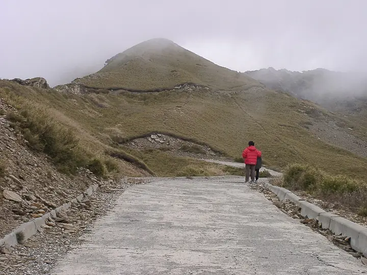 Walking trail at Hehuanshan · 合欢山步道景观 Source-recorded photograph date: 2005-02-10 13:06:33.
Hehuanshan Designated Mountain Trails合欢山正规开放步道
Hehuanshan is a high mountain landscape where designated trails rise through open alpine vegetation and broad stands of Yushan cane.
Read the place guide → Yushan main and east peaks seen from the north peak · 从北峰方向眺望玉山主峰与东峰 Source-recorded photograph date: 2017-06-16.
Yushan Designated Summit Routes玉山正规登山线路
Yushan's designated mountain routes lead into a high-elevation landscape of forest, exposed rock and distinct summit ridges.
Read the place guide → A hotel building with a red gabled roof amid misty mountains at Dongpu Hot Springs, Xinyi Township · 信义乡东埔温泉区,云雾缭绕山间的红顶旅馆建筑 Source-recorded photograph date: Taken on 24 June 2015.
Dongpu Hot Springs东埔温泉
Dongpu is a hot-spring settlement in Xinyi Township, Nantou County, within a mountain landscape closely connected with Bunun community life.
Read the place guide → Chung Tai Chan Monastery in Puli, Nantou County · 南投埔里中台禅寺 Source-recorded photograph date: Taken on 13 June 2008.
Chung Tai Chan Monastery中台禅寺
Chung Tai Chan Monastery is a large Buddhist complex near Puli in Nantou County, combining an active religious institution with monumental contemporary architecture.
Read the place guide →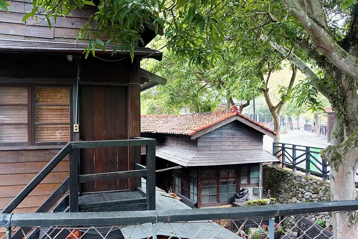 Wooden buildings in Checheng, Shuili · 水里车埕木造建筑 Source-recorded photograph date: Taken on 14 November 2014.
Checheng Railway and Timber Heritage Area车埕
Checheng is a railway and former timber-processing settlement in Shuili Township, Nantou County.
Read the place guide →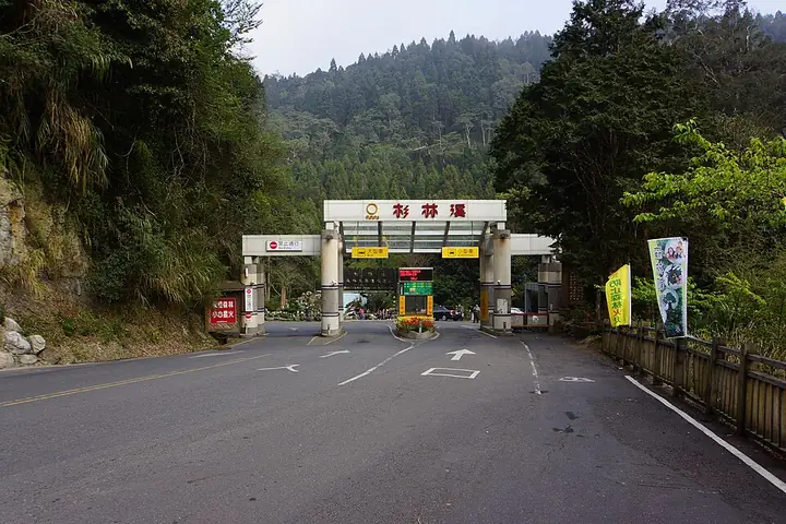 Entrance to Sun Link Sea Forest and Nature Resort · 杉林溪森林生态度假园区入口 Source-recorded photograph date: Taken on 1 March 2013.
Shanlinxi Forest Recreation Area杉林溪森林生态度假园区
Shanlinxi Forest Recreation Area lies in the mountain country of Zhushan, Nantou County, beyond the Xitou approach.
Read the place guide → Jiji railway station in Nantou County · 南投集集车站 Source-recorded photograph date: 2006-12-28 17:15.
Jiji Station and Railway Town集集车站与小镇
Jiji Station is a wooden railway landmark in the centre of Jiji Township, Nantou County.
Read the place guide → Entrance to the Formosan Aboriginal Culture Village · 九族文化村入口 Source-recorded photograph date: 2010-12-24.
Formosan Aboriginal Culture Village九族文化村
Formosan Aboriginal Culture Village is a themed recreation park in Yuchi Township, Nantou County, bringing together cultural presentation, amusement rides and landscaped gardens.
Read the place guide → Forest scenery in Xitou Nature Education Area · 溪头自然教育园区林间景观 Source-recorded photograph date: 2000sdate QS:P,+2000-00-00T00:00:00Z/8.
Xitou Nature Education Area溪头自然教育园区
Xitou Nature Education Area is a forest recreation and learning landscape in Lugu Township, Nantou County.
Read the place guide →Local life & food
Nantou County local specialties
南投縣特色美食 · 10 specialties to discover
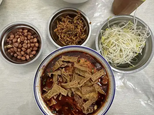 Puli Rice Vermicelli 埔里米粉
Puli Rice Vermicelli (埔里米粉) is a rice-vermicelli specialty associated with Puli (埔里).
Read the dish guide →
Photo adjustments
EXIF orientation normalized; resized without changing aspect ratio; converted to WebP. No subject edits.
 Shaoxing Wine Sausage 绍兴酒香肠
Shaoxing Wine Sausage (绍兴酒香肠) is listed among the local specialties of Nantou County, Taiwan. The term 酒 points to an alcoholic or fermented drink.
Read the dish guide →
Photo adjustments
EXIF orientation normalized; resized without changing aspect ratio; converted to WebP. No subject edits.
 Zhushan Candied Sweet Potatoes 竹山蜜番薯AI illustration · AI 示意图(仅供参考,非实拍)
Zhushan Candied Sweet Potatoes (竹山蜜番薯) is listed among the local specialties of Nantou County, Taiwan. It is grouped here with regional dishes & banquets; retain the complete Chinese name when comparing local menus.
Read the dish guide → Sun Moon Lake Black Tea Eggs 日月潭红茶蛋AI illustration · AI 示意图(仅供参考,非实拍)
Sun Moon Lake Black Tea Eggs (日月潭红茶蛋) are tea eggs sold at Sun Moon Lake (日月潭) in Yuchi Township (魚池鄉), Nantou County (南投縣), Taiwan, and braised with the local black tea.
Read the dish guide → Shuili Ba-Wan Dumplings 水里肉圆
Shuili Ba-Wan Dumplings (水里肉圆) are the ba-wan of Shuili Township (水里乡) in Nantou County (南投县), central Taiwan.
Read the dish guide →
Photo adjustments
EXIF orientation normalized; resized without changing aspect ratio; converted to WebP. No subject edits.
 Caotun Mochi 草屯麻糬AI illustration · AI 示意图(仅供参考,非实拍)
Caotun Mochi (草屯麻糬) belongs to the local rice-food traditions of Caotun (草屯), Nantou (南投).
Read the dish guide → Guoxing Hakka Ground Tea 国姓客家擂茶AI illustration · AI 示意图(仅供参考,非实拍)
Guoxing Hakka Ground Tea (国姓客家擂茶) is a warm, ground tea-and-grain drink associated with Guoxing (國姓), Nantou (南投).
Read the dish guide → Yuchi Black Tea Cuisine 鱼池红茶餐AI illustration · AI 示意图(仅供参考,非实拍)
Yuchi Black Tea Cuisine (鱼池红茶餐) has a local example at the Yuchi Township Farmers’ Association’s Sun Moon Lake Black Tea House (魚池鄉農會日月潭紅茶館), in Nantou County (南投縣).
Read the dish guide →All dish names · 全部菜名 (10)
- Puli Rice Vermicelli · 埔里米粉
- Shaoxing Wine Sausage · 绍兴酒香肠
- Zhushan Candied Sweet Potatoes · 竹山蜜番薯
- Sun Moon Lake Black Tea Eggs · 日月潭红茶蛋
- Shuili Ba-Wan Dumplings · 水里肉圆
- Caotun Mochi · 草屯麻糬
- Guoxing Hakka Ground Tea · 国姓客家擂茶
- Yuchi Black Tea Cuisine · 鱼池红茶餐
- Xinyi Plum Chicken · 信义梅子鸡
- Puli Savory Fried Dough Sticks · 埔里咸油条
More dishes from across Taiwan are in the Taiwan food guide.
Townships, districts & local cities in Nantou County
13 areas belong directly to Nantou County.
13 areas
Nantou City 南投市
Nantou City (Mandarin Pīnyīn: Nántóu Shì; Hokkien POJ: Lâm-tâu-chhī, lit. 'South Tou City') is a county-administered city located in the northwest of Nantou County, Taiwan.
Explore the area →TownshipPuli Township 埔里鎮
Puli Township is an urban township in Nantou County, Taiwan. The township is located within the Puli Basin in central Taiwan.
Explore the area →TownshipCaotun Township 草屯鎮
Caotun Township, formerly transliterated as Tsaotun Township, is an urban township in the northwest of Nantou County, Taiwan. It is the largest township in Taiwan by population.
Explore the area →TownshipZhushan Township 竹山鎮
Zhushan Township is an urban township in the southwest part of Nantou County, Taiwan, and off the south shore of Zhuoshui River.
Explore the area →Show fewer areas
Jiji Township 集集鎮
Jiji or Chichi is an urban township located in the west central portion of Nantou County, Taiwan. Jiji is the smallest of Taiwan's townships by area.
Explore the area →Rural townshipMingjian Township 名間鄉
Mingjian Township is a rural township in western Nantou County, Taiwan. It is the second smallest township in the county, after Jiji Township.
Explore the area →Rural townshipLugu Township 鹿谷鄉
Lugu Township is a rural township located in the southwest of Nantou County, Taiwan. Lugu is known as the home of Dongding Oolong Tea, which was first cultivated on Dong Ding Mountain in the area.
Explore the area →Rural townshipZhongliao Township 中寮鄉
Zhongliao Township is a rural township in Nantou County, Taiwan.
Explore the area →Rural townshipYuchi Township 魚池鄉
Yuchi Township is a rural township in the center of Nantou County, Taiwan. It is the location of the Sun Moon Lake, a tourist attraction.
Explore the area →Rural townshipGuoxing Township 國姓鄉
Guoxing Township is a rural township in Nantou County, Taiwan. As of February 2023, the township has a population total of 17,168.
Explore the area →Rural townshipShuili Township 水里鄉
Shuili Township is a rural township in Nantou County, Taiwan.
Explore the area →Rural townshipXinyi Township 信義鄉
Xinyi Township or Sinyi Township is a mountain indigenous township in Nantou County, Taiwan. It is the largest township by area of Nantou County. Xinyi is home to the Bunun people of the Taiwanese aborigines.
Explore the area →Rural townshipRen'ai Township 仁愛鄉
Ren'ai Township is a mountain indigenous township in Nantou County, Taiwan. It has a population total of 15,670 and an area of 1,273.5312 km², making it the second largest township by area in the county after…
Explore the area →No areas match this name.
Plan your visit
Getting there
Search for 南投縣 in a map app to find stations and your accommodation.
Where to stay →Build your route
Cingjing Farm and Sun Moon Lake are about 35 km apart in a straight line. The linked place guides have entrance and visit details.
Continue with Taiwan →More in Taiwan
Sources & geographic information
Administrative names and parent areas: Official geographic directory · Reference date 2026-09-06.
Background text adapted from Nantou County — Wikipedia contributors, under CC BY-SA 4.0. Text has been shortened and reorganized; source revision 1370830330.
Photo: Cingjing Farm · Professional Maniniyot Wannabe · CC BY 2.0. Full-frame source proportionally resized and converted to WebP for display. No subject alteration. Source-supplied marks and edits remain; cards may crop the view.

Photo: Sun Moon Lake · Alankang · CC BY-SA 4.0. Full-frame source proportionally resized and converted to WebP for display. No subject alteration. Source-supplied marks and edits remain; cards may crop the view.

Photo: Yushan National Park Tataka Recreation Area · Yiken · CC BY-SA 3.0. Full-frame source proportionally resized and converted to WebP for display. No subject alteration. Source-supplied marks and edits remain; cards may crop the view.

Photo: Hehuanshan Designated Mountain Trails · Dquai · CC BY-SA 4.0. Full-frame source proportionally resized and converted to WebP for display. No subject alteration. Source-supplied marks and edits remain; cards may crop the view.

Photo: Yushan Designated Summit Routes · Huang Chung Yu · CC BY-SA 4.0. Full-frame source proportionally resized and converted to WebP for display. No subject alteration. Source-supplied marks and edits remain; cards may crop the view.

Photo: Dongpu Hot Springs · lienyuan lee · CC BY 3.0. Full frame retained; proportionally resized and converted to WebP. No retouching or changes to the photographed subject. Card displays may crop the view.

Photo: Chung Tai Chan Monastery · lienyuan lee · CC BY 3.0. Full-frame source proportionally resized and converted to WebP for display. No subject alteration. Source-supplied marks and edits remain; cards may crop the view.

Photo: Checheng Railway and Timber Heritage Area · lienyuan lee · CC BY 3.0. Full-frame source proportionally resized and converted to WebP for display. No subject alteration. Source-supplied marks and edits remain; cards may crop the view.

Photo: Shanlinxi Forest Recreation Area · lienyuan lee · CC BY 3.0. Full-frame source proportionally resized and converted to WebP for display. No subject alteration. Source-supplied marks and edits remain; cards may crop the view.

Photo: Jiji Station and Railway Town · Takoradee~commonswiki · CC BY 2.5. Full-frame source proportionally resized and converted to WebP for display. No subject alteration. Source-supplied marks and edits remain; cards may crop the view.

Photo: Formosan Aboriginal Culture Village · sfmine79 · CC BY 2.0. Full-frame source proportionally resized and converted to WebP for display. No subject alteration. Source-supplied marks and edits remain; cards may crop the view.

Photo: Xitou Nature Education Area · Dquai · CC BY-SA 4.0. Full-frame source proportionally resized and converted to WebP for display. No subject alteration. Source-supplied marks and edits remain; cards may crop the view.

Map data © OpenStreetMap contributors. Pins mark approximate centres, not entrances or boundaries.