


Get to know Cangshan District

Photo adjustments
Full frame retained; proportionally resized and converted to WebP. No retouching or changes to the photographed subject. Card displays may crop the view.
- Administrative area
- District · 市辖区
- Part of
- Fuzhou
- Chinese name
- 仓山区
- Local areas
- District guide
Area & population
- Area in the source
- 139.00 km²
- Population · 2020
- 1,142,991
Source: cited geographic source, as of the dates shown.
Setting and landscape
Across the northern branch lie the Gulou (鼓楼), Taijiang (台江), Jin'an (晋安) and Mawei (马尾) districts; the southern branch, the Wulong River (乌龙江), divides it from Minhou (闽侯县). The island is a hilly plain: hills and slopes cover about a fifth of it, and Gaogai Mountain (高盖山), 202 metres high in the middle of the island, is the highest point. Broad sandbanks form along the river, which is tidal here and flows both ways.
The climate is a south subtropical maritime monsoon type with about 1,396 millimetres of rain a year, nearly three quarters of it between April and September. A plum-rain season of around 40 days starts in mid-May, and typhoons affect the district from June to September.
History
The district's name goes back to Yantai Shan (烟台山), the low hill on its northern shore. A temple built there under the Northern Song was renamed Tianning in 1111, and at the end of the Yuan the Fuzhou authorities put a beacon tower on the summit, which gave the hill its present name. In the Hongwu reign of the Ming, salt warehouses were built at its northern foot, and the area became known as Cangqian Shan (仓前山), "the hill in front of the warehouses", shortened to Cangshan.
After the Treaty of Nanjing of 1842 opened Fuzhou as a treaty port, the district became its consular quarter: between 1844 and 1903, seventeen countries opened consulates or agencies here. A Cangshan district office was set up in 1945; the district was called Chaoyang from 1968 to 1978, and it took in the whole island in 1996.
What to see
Yantai Shan, on the south bank of the Min, is about 41.6 metres above sea level. Several countries set up consulates on it and built churches, schools and hospitals, and groups of these buildings survive. Yantai Shan Park, opened on the summit on 1 October 1964, holds the remains of the old beacon tower, and the hill was approved as a national 3A tourist attraction in 2021.
Shishan village (狮山村) at the heart of the old Linpu (林浦) settlement is protected under a Fujian historic and cultural village plan. At its entrance stands the Shangshuli stone archway (尚书里石牌坊), raised in the Longqing reign of the Ming to honour the family of Lin Han (林瀚), five of whom became ministers over three generations. Ming and Qing houses with firewall gables and the Song-dynasty Lin Bridge (林桥) stand in the village, which is closely tied to the Lianjiang Academy (濂江书院), where Zhu Xi (朱熹) taught.
Highlights
- Yantai Shan 烟台山: Low riverside hill with old consulate, church and school buildings; a 3A tourist attraction since 2021.
- Shangshuli stone archway 尚书里石牌坊: Ming archway honouring the Lin family of Linpu, with five ministers in three generations.
- Lianjiang Academy 濂江书院: Old academy tied to Linpu's Shishan village, where Zhu Xi lectured.
- Gaogai Mountain 高盖山: At 202 metres, the highest point on Nantai Island.
Sources for this guide
自然地理 - 福州市仓山区人民政府 · Cangshan District People's Government, Fuzhou
仓山区 - 维基百科 · Wikipedia (Chinese) · CC BY-SA 4.0
烟台山 (福州) - 维基百科 · Wikipedia (Chinese) · CC BY-SA 4.0
仓山狮山村:千年文脉润古今 - 福州市仓山区人民政府 · Cangshan District People's Government, Fuzhou
Original English written from the listed sources and checked sentence by sentence against quoted extracts by a separate reviewer. Updated 2026-09-23.
Explore Cangshan District
Core places to explore, with English and Chinese names.
Places to explore around Cangshan District
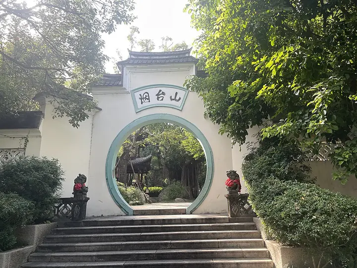 The Moon Palace Gate at Yantai Hill Park, Cangshan District, Fuzhou ·
 Plan your visit
Getting there
Cangshan District covers the centre of Fuzhou. Search for 仓山区 in a map app to find stations and your accommodation.
Where to stay →Build your route
Start with Yantaishan Historic Area. The linked place guides have entrance and visit details.
Continue with Fuzhou →More in Fuzhou
Sources & geographic information
Administrative names and parent areas: Official geographic directory · Reference date 2026-09-06.
Some facts checked against 仓山区 — Wikipedia contributors, CC BY-SA 4.0.
Some facts checked against 烟台山 (福州) — Wikipedia contributors, CC BY-SA 4.0.
Photo: Yantaishan Historic Area · Yejianfei · Yejianfei — 福州市烟台山公园月宫门.jpg — CC0 · CC0. Full frame retained; proportionally resized and converted to WebP. No retouching or changes to the photographed subject. Card displays may crop the view.

Map data © OpenStreetMap contributors. Pins mark approximate centres, not entrances or boundaries.