


Get to know Taijiang District

Photo adjustments
Full frame retained; proportionally resized and converted to WebP. No retouching or changes to the photographed subject. Card displays may crop the view.
- Administrative area
- District · 市辖区
- Part of
- Fuzhou
- Chinese name
- 台江区
- Local areas
- District guide
Area & population
- Population · 2020
- 411,819
Source: cited geographic source, as of the dates shown.
Setting and landscape
The main channel of the Min forms the boundary with Cangshan District (仓山区) to the west and south, while Guangming Harbour (光明港) and the Jin'an River (晋安河) separate it from Jin'an District (晋安区) to the east; Gulou District (鼓楼区) lies to the north. Most of the district was once water, and it is still threaded by canals and creeks such as the Baima River (白马河), Chating River (茶亭河) and Sanjie River (三捷河). Bridges including the Jiefang Bridge (解放大桥) and Aofeng Bridge (鳌峰大桥) cross the Min from here.
History
The name goes back to Damiao Hill (大庙山). In 202 BC Wuzhu (无诸) built a terrace there when he was made King of Minyue (闽越), and the later Dongyue king Yushan (余善) built the Diaolong Terrace (钓龙台) by the river. In 908 the Min ruler Wang Shenzhi (王审知) looked out from Fuzhou's new southern wall to 'terraces by the river', which gave Taijiang and Nantai their names. In 1956 Taijiang and Xiaoqiao (小桥区) districts were merged as Taijiang District, which was called Chiwei District (赤卫区) from 1968 until 1978. The translator Lin Shu (林纾) and the soda-industry chemist Hou Debang (侯德榜) came from Taijiang.
What to see
Shangxiahang (上下杭), the historic block around Shanghang Road (上杭路) and Xiahang Road (下杭路), grew on two sandbanks south of Damiao Hill that served as natural landings for boats; the street names come from hang (航), a landing place. After Fuzhou was opened as a treaty port in the late Qing it became the centre of the import and export trade, with tea firms the most influential among its merchant houses. Surviving buildings include the Jianjun Guild Hall (建郡会馆), built by merchants from Jianning prefecture (建宁府) in the Jiaqing era and listed as a provincial protected site in 2026, and the Pucheng Guild Hall (浦城会馆), whose main hall is also called the Tianhou Palace (天后宫). Four old shops, among them the Shengshun tea store (生顺茶栈), were listed together as the Shangxiahang merchant buildings on 28 January 2013.
Getting oriented
Fuzhou Metro Lines 1, 2 and 4 all have stations in the district, including Chating (茶亭) and Dadao (达道) on Line 1, and the Fuzhou South long-distance bus station is here.
Highlights
- Shangxiahang 上下杭: Historic merchant block on former river landings; trading centre after Fuzhou became a treaty port.
- Jianjun Guild Hall 建郡会馆: Jiaqing-era merchants' hall on Shanghang Road, a provincial protected site since 2026.
- Damiao Hill 大庙山: Site of the Minyue king's terrace that gave Taijiang its name.
Sources for this guide
台江概况 · Taijiang District People's Government, Fuzhou (district gazetteer office)
台江区 - 维基百科 · Wikipedia (Chinese) · CC BY-SA 4.0
上下杭 - 维基百科 · Wikipedia (Chinese) · CC BY-SA 4.0
Original English written from the listed sources and checked sentence by sentence against quoted extracts by a separate reviewer. Updated 2026-09-23.
Explore Taijiang District
Core places to explore, with English and Chinese names.
Places to explore around Taijiang District
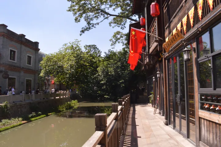 Canal-side street in the Shangxiahang historic district, Taijiang District, Fuzhou ·
 Plan your visit
Getting there
Taijiang District covers the centre of Fuzhou. Search for 台江区 in a map app to find stations and your accommodation.
Where to stay →Build your route
Start with Shangxiahang Historic District. The linked place guides have entrance and visit details.
Continue with Fuzhou →More in Fuzhou
Sources & geographic information
Administrative names and parent areas: Official geographic directory · Reference date 2026-09-06.
Some facts checked against 台江区 — Wikipedia contributors, CC BY-SA 4.0.
Some facts checked against 上下杭 — Wikipedia contributors, CC BY-SA 4.0.
Photo: Shangxiahang Historic District · Cyclohexane233 · CC BY-SA 4.0. Full frame retained; proportionally resized and converted to WebP. No retouching or changes to the photographed subject. Card displays may crop the view.

Map data © OpenStreetMap contributors. Pins mark approximate centres, not entrances or boundaries.