


Get to know Jin'an District
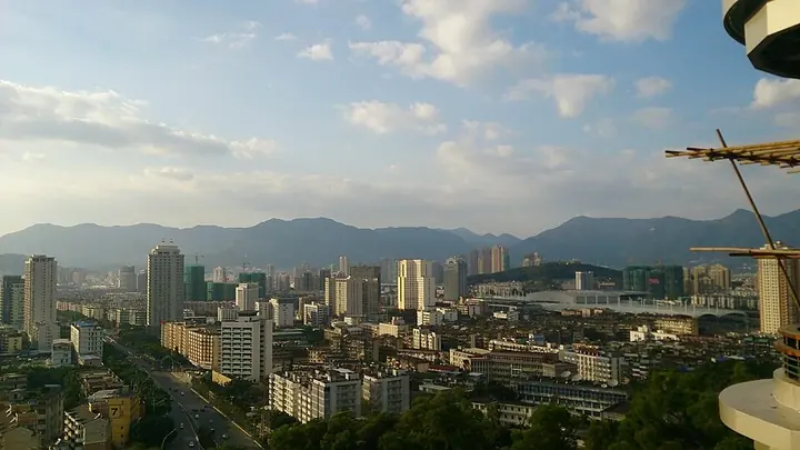
Photo adjustments
Full frame retained; proportionally resized and converted to WebP. No retouching or changes to the photographed subject. Card displays may crop the view.
- Administrative area
- District · 市辖区
- Part of
- Fuzhou
- Chinese name
- 晋安区
- Local areas
- District guide
Area & population
- Population · 2020
- 789,775
Source: cited geographic source, as of the dates shown.
Setting and landscape
The district lies on the northern and north-eastern rim of the Fuzhou Basin (福州盆地) and slopes down from north-east to south-west. A spur of the Jiufeng Mountains (鹫峰山) descends through it in three steps: middle-mountain country in the north around Rixi (日溪), Shoushan and Huanxi (宦溪); a belt of low hills; and a plain. The highest point is Qilin Mountain (麒麟山), 1,129.3 m, on the Rixi–Shoushan boundary; the lowest, at Liuyi village (六一村) in Gushan town (鼓山镇), is only 1.2 m above sea level.
History
In 202 BC the area belonged to the Minyue kingdom (闽越国), and in 282 to Yuanfeng County (原丰县) in the Jin'an Commandery (晋安郡). From 981 Xindian (新店镇) and the Beifeng townships belonged to the new Huai'an County (怀安县), which was merged into Houguan (侯官县) in 1580. In 1996 Fuzhou's suburban district was renamed Jin'an District, and some of its townships went to Gulou, Taijiang, Cangshan and the new Mawei district.
What to see
Mount Gu rises on the district's eastern side. Its cliff inscriptions, called the "Stele Forest of the South-East" (东南碑林), are a nationally protected cultural relic, and the mountain is an example of miarolitic granite scenery. Yongquan Temple (涌泉寺) on the mountain carries a plaque written by the Kangxi Emperor and is a national key temple of Han Chinese Buddhism; the district government notes the view of Taiwanese scholars that about three quarters of Taiwan's Buddhist temples trace their lineage to it.
Guling, about 12 km from the city centre at an average altitude of 750–800 m, was opened as a summer retreat by foreign residents in the mid-19th century. Yixia village (宜夏村) keeps the sites of a foreigners' club, a swimming pool and a church, and an old path of more than 2,000 stone steps climbs up from Shanxi (鳝溪) in Gushan town. Fuzhou National Forest Park (福州国家森林公园), founded as an arboretum in 1960, was Fujian's first national forest park. In the northern hills, the Fujian Shoushan National Mine Park (福建寿山国家矿山公园), in the first national batch of 2005, covers Shoushan, Rixi and Huanxi and includes the China Shoushan Stone Museum (中国寿山石馆) and the Rixi Grand Canyon (日溪大峡谷).
Highlights
- Gushan cliff inscriptions and Yongquan Temple 鼓山涌泉寺: Cliff carvings known as the Stele Forest of the South-East; temple with a Kangxi Emperor plaque.
- Guling 鼓岭: Hill retreat opened by foreign residents in the mid-19th century, with club, pool and church sites at Yixia village.
- Fuzhou National Forest Park 福州国家森林公园: Founded as an arboretum in 1960; Fujian's first national forest park.
- Fujian Shoushan National Mine Park 福建寿山国家矿山公园: One of the first national mine parks (2005), centred on Shoushan stone.
Sources for this guide
晋安区 - 维基百科,自由的百科全书 · Chinese Wikipedia · CC BY-SA 4.0
自然地理_自然地理_福州市晋安区人民政府 · Jin'an District People's Government, Fuzhou
建制沿革_建制沿革_福州市晋安区人民政府 · Jin'an District People's Government, Fuzhou
鼓山风景名胜区“五大名胜古迹及其文化”_名胜古迹_福州市晋安区人民政府 · Jin'an District People's Government, Fuzhou
鼓岭旅游度假区_名胜古迹_福州市晋安区人民政府 · Jin'an District People's Government, Fuzhou
福州国家森林公园_名胜古迹_福州市晋安区人民政府 · Jin'an District People's Government, Fuzhou
福建寿山国家矿山公园_名胜古迹_福州市晋安区人民政府 · Jin'an District People's Government, Fuzhou
Original English written from the listed sources and checked sentence by sentence against quoted extracts by a separate reviewer. Updated 2026-09-25.
Explore Jin'an District
Core places to explore, with English and Chinese names.
Places to explore around Jin'an District
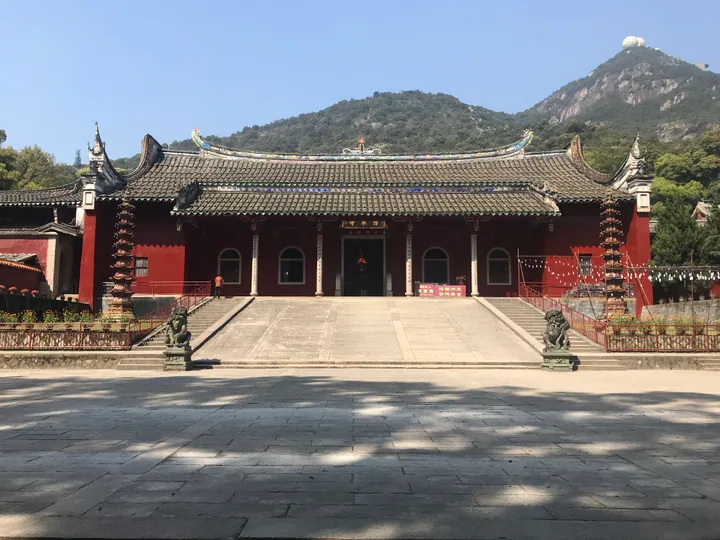 The main hall of Yongquan Temple on Gushan, with the mountain rising behind it, in Jin'an District, Fuzhou. · 福州市晋安区鼓山涌泉寺大殿,背靠鼓山。 Source-recorded photograph date: 2019-03-12 14:16:37.
Gushan Yongquan Temple鼓山涌泉寺
Buddhist monastery on Mount Gu in Fuzhou, founded in 783, with terraced Ming-Qing halls and two pottery pagodas of 1082.
Read the place guide →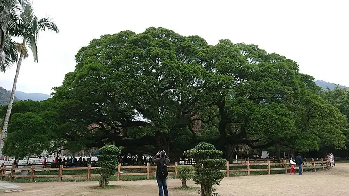 Banyan King in Fuzhou National Forest Park · 福州国家森林公园千年古榕 Photograph date recorded by the source: 21 January 2018, 14:28:17.
Fuzhou National Forest Park福州国家森林公园
Fuzhou National Forest Park brings together planted collections and a wooded valley on the northern edge of the city. Longtan Stream runs through the grounds, and the specialist gardens include bamboo, banyans and rare plants…
Read the place guide →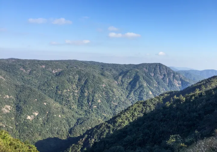 Forested mountain ridges at Guling (Kuliang), Jin'an District, Fuzhou · 福州市晋安区鼓岭山峦景观 Source-recorded photograph date: 2017-01-26 15:18:18.
Guling Scenic Area鼓岭
Hill resort north of Mount Gu near Fuzhou, founded by foreign residents from 1886, with the International Club, villa ruins and a Gardner exhibition.
Read the place guide →Plan your visit
Getting there
Jin'an District is about 5 km in a straight line from central Fuzhou. Search for 晋安区 in a map app to find stations and your accommodation.
Where to stay →Build your route
Gushan Yongquan Temple and Fuzhou National Forest Park are both listed here. The linked place guides have entrance and visit details.
Continue with Fuzhou →More in Fuzhou
Sources & geographic information
Administrative names and parent areas: Official geographic directory · Reference date 2026-09-06.
Some facts checked against 晋安区 — Wikipedia contributors, CC BY-SA 4.0.
Photo: Gushan Yongquan Temple · Zhangzhugang · CC BY-SA 4.0. Full frame retained; proportionally resized and converted to WebP. No retouching or changes to the photographed subject. Card displays may crop the view.

Photo: Fuzhou National Forest Park · SmileYuki · SmileYuki — Banyan King in Fuzhou National Forest Park 2018.01.jpg — CC BY-SA 4.0 · CC BY-SA 4.0. The exact downloaded source bytes are separately retained and hashed. Prepared JPEG is proportionally reduced to a maximum 720-pixel long edge; full frame retained, no subject alteration. Final website rendition: full frame retained, proportionally resized to at most 720 pixels and converted to WebP. No additional retouching or subject alteration. Card displays may crop the view.

Photo: Guling Scenic Area · N509FZ · CC BY-SA 4.0. Full frame retained; proportionally resized and converted to WebP. No retouching or changes to the photographed subject. Card displays may crop the view.
.jpg)
Map data © OpenStreetMap contributors. Pins mark approximate centres, not entrances or boundaries.