


Get to know Shaowu
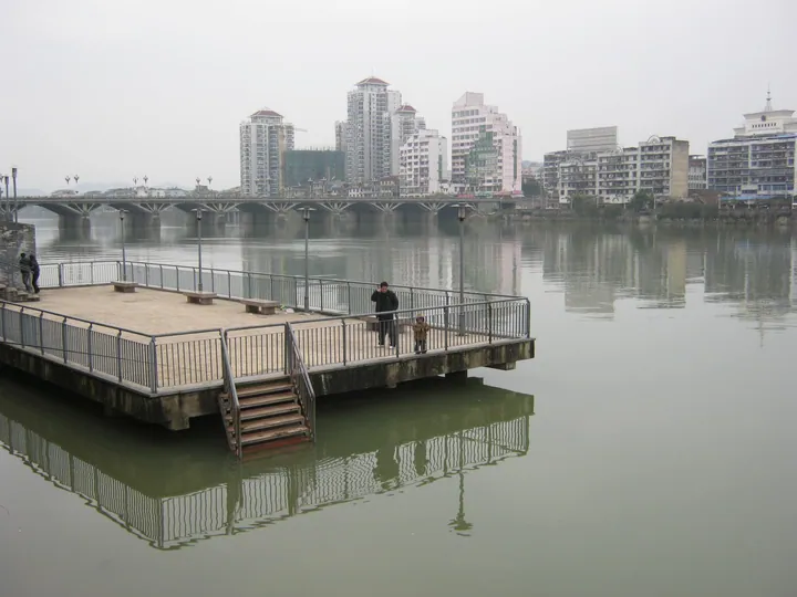
Photo adjustments
Full frame retained; proportionally resized and converted to WebP. No retouching or changes to the photographed subject. Card displays may crop the view.
- Administrative area
- County-level city · 县级市
- Part of
- Nanping
- Chinese name
- 邵武市
- Local areas
- County-level city guide
Area & population
- Area in the source
- 2,859.60 km²
- Population · 2020
- 273,721
Source: cited geographic source, as of the dates shown.
History
In the early Han, the Minyue king Wuzhu (无诸) built Wuban (乌坂城) on the upper Futun, at today's Guxian village in Shuibei town (水北镇). The Wu state of the Three Kingdoms (孙吴) made it the seat of a new Zhaowu County (昭武县) in 260, and in 291 the name became Shaowu to avoid the personal name of Sima Zhao (司马昭). In 979 the Song created Shaowu Military Prefecture (邵武军), one of the eight second-level divisions behind the name "Eight Min" (八闽) for Fujian; its seat moved to a new earthen-walled town on the south bank of the Futun. Shaowu became a county-level city in 1983. The city describes itself as a former Central Soviet county and one-time seat of the Fujian provincial Party committee.
What to see
Heping town (和平镇) is listed as a Chinese historical and cultural town. Its written history begins in the Tang, when it was called Zhoujin (昼锦), and a Heping sub-county was set up here in 1769; the city says it is the home town of Zhang Sanfeng (张三丰). Shaowu itself is a provincial-level historical and cultural city and has four national 4A scenic areas. Revolutionary sites include the former seat of the Fujian provincial Party committee and the temporary headquarters of the Red Third Army Corps (红三军团).
Culture and local products
Shaowu Nuo dance (傩舞) is on the national intangible heritage list. Bamboo and timber processing is one of the leading local industries, and the city has created a regional bamboo brand called "Wuyi Bamboo Cube" (武夷竹立方).
Getting oriented
Jianyang District lies to the northeast, Shunchang County to the southeast, Jiangle, Taining and Jianning counties of Sanming (三明) to the south, and Guangze County to the northwest. The Yingtan–Xiamen railway has a Shaowu station, and national highway G316 passes through.
Highlights
- Heping 和平镇: A Chinese historical and cultural town, seat of a Heping sub-county from 1769.
- Shaowu Nuo dance 邵武傩舞: On the national intangible heritage list.
- Former seat of the Fujian provincial Party committee 中共福建省委旧址: One of 30 revolutionary sites in Shaowu.
Sources for this guide
邵武概况 · Shaowu Municipal People's Government
地理环境 · Shaowu Municipal People's Government
邵武市 - 维基百科,自由的百科全书 · Wikipedia (Chinese) · CC BY-SA 4.0
和平镇 (邵武市) - 维基百科,自由的百科全书 · Wikipedia (Chinese) · CC BY-SA 4.0
Original English written from the listed sources and checked sentence by sentence against quoted extracts by a separate reviewer. Updated 2026-09-23.
Explore Shaowu
Core places to explore, with English and Chinese names.
Places to explore around Shaowu
 AI illustration · AI 示意图(仅供参考,非该地点实拍)
Heping Ancient Town和平古镇
Heping (和平古镇) is an old town in Shaowu, Nanping, Fujian, on the road that once had to be taken from Jiangxi into Fujian, where close to two hundred grand Ming and Qing houses and an early academy survive.
Read the place guide →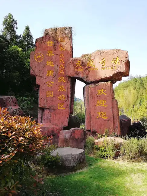 Tiancheng Gorge · 天成奇峡
Tiancheng Gorge天成奇峡
Tiancheng Qixia (天成奇峡) is a danxia gorge landscape of roughly 1,200 hectares in Xiaojiafang town, in the southwest of Shaowu city in Nanping, Fujian. Ridged red rock hills, a stream running through fissure-cut ravines and a densely wooded, protected setting are what define it.
Read the place guide →Plan your visit
Getting there
Shaowu is about 105 km in a straight line from central Nanping. Search for 邵武市 in a map app to find stations and your accommodation.
Where to stay →Build your route
Heping Ancient Town and Tiancheng Gorge are both listed here. The linked place guides have entrance and visit details.
Continue with Nanping →More in Nanping
Sources & geographic information
Administrative names and parent areas: Official geographic directory · Reference date 2026-09-06.
Some facts checked against 邵武市 — Wikipedia contributors, CC BY-SA 4.0.
Some facts checked against 和平镇 (邵武市) — Wikipedia contributors, CC BY-SA 4.0.
Photo: Tiancheng Gorge · Source photographer · License not provided. EXIF orientation normalized; resized without changing aspect ratio; converted to WebP. No subject edits.
Map data © OpenStreetMap contributors. Pins mark approximate centres, not entrances or boundaries.