


Get to know Shunchang County
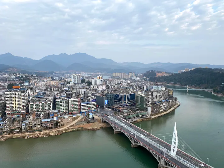
Photo adjustments
Full frame retained; proportionally resized and converted to WebP. No retouching or changes to the photographed subject. Card displays may crop the view.
- Administrative area
- County · 县
- Part of
- Nanping
- Chinese name
- 顺昌县
- Local areas
- County guide
Area & population
- Population · 2020 census
- 179,064
Source: cited geographic source, as of the dates shown.
Setting and landscape
The Futun rises at Wushan (巫山) in Shaowu and enters the county from the northwest at Fuwen (富文); the Jinxi, 224 kilometres long from its source in Ninghua County (宁化县), comes in from the southwest. They join near the county town in Shuangxi subdistrict (双溪街道) and flow east past Yangkou (洋口) into Nanping and the Min. The ranges are offshoots of the Wuyi Mountains, and peaks above 1,000 metres ring every border except the southeast; the highest in the northwest is Baoshan (宝山) at 1,304 metres, and Guoyanshan (郭岩山) reaches 1,384 metres in the northeast. The county has been named a home of bamboo, of Chinese fir and of bamboo fungus (竹荪).
History
In 629 the Tang carved a settlement called Jiangshui (将水场) out of Jiangle County (将乐县). Later renamed Yongshun (永顺场), it was raised to a county named Shunchang in 933, under the Later Tang; a Qing gazetteer of Yanping Prefecture explains the name as "obedient and prosperous", because the area submitted early. Yangkou, on the Futun, was a river port in the 1930s, nicknamed "Little Fuzhou" (小福州) and counted among the four famous towns of Fujian. In 1933 Peng Dehuai's Eastern Army stayed there for 39 days and set up a soviet government.
What to see
Baoshan Temple (宝山寺), on Baoshan in Shanghu village in Dagan town (大干镇), was founded in 1363 under the Yuan, and its surviving main hall is a Yuan building. It is a stone building imitating timber construction, carries more than a dozen Yuan, Ming and Qing inscriptions, and became a national protected site in 2001.
Huayang Mountain (华阳山), a national 4A scenic area 6 kilometres northwest of the county town, covers 12 square kilometres around a 586-metre main peak. Water falls in three tiers to form a cascade, and more than 100 kinds of climbing vine grow in the area. Jiulong Lake below is crossed by the Jiulong covered bridge (九龙廊桥), built in 2005 on the model of the rainbow bridge in the Song painting "Along the River During the Qingming Festival": 99 metres long, it spans the 19.9-metre dam in a single timber arch joined without iron nails.
Highlights
- Baoshan Temple main hall 宝山寺大殿: Yuan-dynasty stone hall of a temple founded in 1363; a national protected site since 2001.
- Huayang Mountain 华阳山: National 4A scenic area with a three-tier waterfall and the Jiulong covered bridge.
- Yangkou 洋口镇: Old Futun river port nicknamed Little Fuzhou.
Sources for this guide
地理环境 · Shunchang County People's Government
建制沿革 · Shunchang County People's Government
华阳山——国家AAAA级旅游景区 · Shunchang County Culture, Sports and Tourism Bureau (via county government portal)
千年古镇 红色洋口 · Shunchang County People's Government
顺昌县 - 维基百科,自由的百科全书 · Wikipedia (Chinese) · CC BY-SA 4.0
宝山寺 (顺昌) - 维基百科,自由的百科全书 · Wikipedia (Chinese) · CC BY-SA 4.0
Original English written from the listed sources and checked sentence by sentence against quoted extracts by a separate reviewer. Updated 2026-09-23.
Explore Shunchang County
Core places to explore, with English and Chinese names.
Shunchang County 顺昌县
Plan your visit
Getting there
Shunchang County is about 40 km in a straight line from central Nanping. Search for 顺昌县 in a map app to find stations and your accommodation.
Where to stay →More in Nanping
Sources & geographic information
Administrative names and parent areas: Official geographic directory · Reference date 2026-09-06.
Some facts checked against 顺昌县 — Wikipedia contributors, CC BY-SA 4.0.
Some facts checked against 宝山寺 (顺昌) — Wikipedia contributors, CC BY-SA 4.0.
Map data © OpenStreetMap contributors. Pins mark approximate centres, not entrances or boundaries.