


Get to know Yanping District
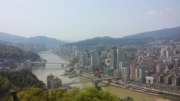
Photo adjustments
Full frame retained; proportionally resized and converted to WebP. No retouching or changes to the photographed subject. Card displays may crop the view.
- Administrative area
- District · 市辖区
- Part of
- Nanping
- Chinese name
- 延平区
- Local areas
- District guide
Area & population
- Area in the source
- 2,660.00 km²
- Population · 2020
- 454,605
Source: cited geographic source, as of the dates shown.
Setting and landscape
Hills ring the riverside town. It was once the key gateway to Fuzhou (福州): travellers leaving Fuzhou for other provinces had to go up the Min River to Yanping. The old city sits between the Jianxi and the Xixi, and newer quarters have spread below Yuping Mountain (玉屏山) and Jiufeng Mountain (九峰山). Since the Shuikou Hydropower Station (水口水电站) was built, the three rivers here have risen into a reservoir called Yanping Lake (延平湖).
The urban area's Nanping dialect (南平话) is a form of Mandarin, one of two Mandarin speech islands in Fujian; other parts of the district speak Eastern Min, Northern Min and Central Min varieties.
History
The county was founded in AD 196 under the Eastern Han, one of the five oldest counties in Fujian. From 946 it served as the seat of a second-tier administrative region. In the Song dynasty 331 candidates from here passed the jinshi exam, and the Four Worthies of Yanping (延平四贤), Yang Shi (杨时), Luo Congyan (罗从彦), Li Tong (李侗) and Zhu Xi (朱熹), founded academies and taught here. Hai Rui (海瑞) was the county's education official in 1552–1556, and Koxinga (郑成功) drilled his navy here.
What to see
Xiayang (峡阳镇), in the north-west of the district 50 km from the city, is a provincial historic town crossed by the Futun River (富屯溪). Xiayang Village and Jiangsi Village (江汜村) were listed as Chinese traditional villages in 2013 and 2016. Its old buildings include the Zhuangyuan Shrine (状元祠), Pingshan Academy (屏山书院), Zhaoke Pagoda (招科塔) and the Guan-Yue Temple (关岳庙); the Zhang family's Baiyin Hall (百忍堂) and three old houses are provincial protected sites.
Zhanghu (樟湖镇), the largest market town on the middle Min River and rebuilt for people resettled from the Shuikou reservoir, keeps a snake-worship tradition placed on Fujian's first intangible-heritage list in 2005. Its Snake King Temple (蛇王庙) is a provincial protected site; villagers parade snake lanterns in the first lunar month, and at the temple fair on the seventh day of the seventh month they carry live snakes in the procession and afterwards release them into the Min River.
Food and local products
Zhanghu households brew glutinous-rice red wine and cook pork and fish in its lees; pork belly with lees and bamboo shoots is eaten at the start of summer. Local sugarcane is made into slab brown sugar (板糖), and Zhanghu fried cake (樟湖炒糕) is on the city intangible-heritage list, as is the Xiayang banquet (峡阳福宴).
Highlights
- Xiayang old town 峡阳镇: Provincial historic town on the Futun River with academies, a pagoda and protected old houses.
- Zhanghu snake customs 延平樟湖崇蛇习俗: Snake worship listed as Fujian intangible heritage in 2005, centred on the Snake King Temple.
- Zhansheng drum 战胜鼓: Drum tradition of Xiayang on the provincial intangible-heritage list.
Sources for this guide
延平区情简介 · Yanping District People's Government, Nanping
延平区人文历史 · Yanping District People's Government, Nanping
峡阳镇 · Yanping District People's Government, Nanping
樟湖镇 · Yanping District People's Government, Nanping
延平区 - 维基百科,自由的百科全书 · Wikipedia (Chinese) · CC BY-SA 4.0
Original English written from the listed sources and checked sentence by sentence against quoted extracts by a separate reviewer. Updated 2026-09-23.
Explore Yanping District
Core places to explore, with English and Chinese names.
Yanping District 延平区
Plan your visit
Getting there
Yanping District covers the centre of Nanping. Search for 延平区 in a map app to find stations and your accommodation.
Where to stay →More in Nanping
Sources & geographic information
Administrative names and parent areas: Official geographic directory · Reference date 2026-09-06.
Some facts checked against 延平区 — Wikipedia contributors, CC BY-SA 4.0.
Map data © OpenStreetMap contributors. Pins mark approximate centres, not entrances or boundaries.