


Get to know Songxi County
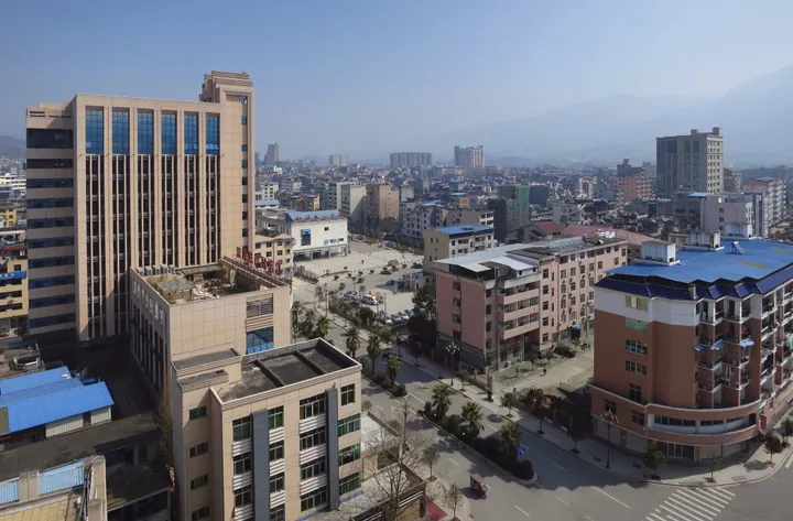
Photo adjustments
Full frame retained; proportionally resized and converted to WebP. No retouching or changes to the photographed subject. Card displays may crop the view.
- Administrative area
- County · 县
- Part of
- Nanping
- Chinese name
- 松溪县
- Local areas
- County guide
Area & population
- Area in the source
- 1,043.00 km²
- Population · 2020
- 130,867
- Administrative seat
- Songyuan
Source: cited geographic source, as of the dates shown.
Setting and landscape
The county lies where the southern end of the Xianxia Range (仙霞岭) meets outliers of the Donggong Mountains (洞宫山). Low and middle mountains ring it, with valley plains along the streams in the centre. The Songxi river enters in the northeast and cuts diagonally to the southwest. The highest point is Longtoushan (龙头山), 1,349 metres, in Xidong township (溪东乡) in the north; Zhanlu Mountain (湛卢山), whose main Zhanyun Peak reaches 1,230 metres, is a provincial scenic area, and Baima Mountain (白马山) is a provincial nature reserve.
History
In 941 Wang Yanzheng (王延政) of the Min kingdom took most of the Dongping area from Wuyue and set up the town of Songyuan (松源镇). The Southern Tang made it Songyuan County in 951, and in 975 the Northern Song renamed it Songxi. The county was twice merged with Zhenghe County (政和县) as Songzheng County (松政县), in 1960–1962 and 1970–1975. Jiuxian (旧县) township, the former seat, keeps a Song-dynasty stele recording traffic rules.
What to see
Local legend places the forging of the Zhanlu sword by the Spring and Autumn swordsmith Ouye Zi (欧冶子) on Zhanlu Mountain, where a sword-testing rock, a sword pool and furnace ruins are pointed out and Qingliang Temple (清凉寺) crowns the summit. Zhu Xi (朱熹) came to the mountain on his way back from an official examination in 1151 and stayed until January 1153, waiting to take up his post at Tong'an (同安), and built a study called the Yinshi (吟室) below Jian Peak; a century later it was enlarged as the Zhanlu Academy (湛卢书院). On Hushan (虎山), a hill west of the county town, rises the Kuiguang Pagoda (奎光塔), which dates back to the Southern Song; the Jiulong kiln site (九龙窑址), from the Northern Song, are on the western outskirts. Weitian (渭田) has Western Jin tombs and the Qing-built Wufu Bridge (五福桥).
Food and local products
At Wanqian village (万前村) in Zhengdun town (郑墩镇), a 0.7-mu patch of "hundred-year sugarcane" (百年蔗), planted in the Yongzheng reign of the Qing, still sends up shoots around the Qingming festival. It is a sugar-making cane, and the brown sugar made from it is yellow-brown, crisp and sweet. The county also promotes itself as a centre of white tea and of printmaking.
Highlights
- Zhanlu Mountain 湛卢山: Provincial scenic area linked by legend to the Zhanlu sword; Zhu Xi's study stood here.
- Hundred-year sugarcane 百年蔗: A Qing-era sugarcane patch at Wanqian village that still sprouts each year.
- Kuiguang Pagoda 奎光塔: First built in the Southern Song, on Hushan west of the town.
- Longtoushan 龙头山: The county's highest peak, 1,349 metres.
Sources for this guide
地质地貌 · Songxi County People's Government
朱熹与湛卢山“吟室” · Songxi County People's Government
“百年蔗”红糖 古法的传承 · Songxi County People's Government
松溪县 - 维基百科,自由的百科全书 · Wikipedia (Chinese) · CC BY-SA 4.0
Original English written from the listed sources and checked sentence by sentence against quoted extracts by a separate reviewer. Updated 2026-09-23.
Explore Songxi County
Core places to explore, with English and Chinese names.
Songxi County 松溪县
Plan your visit
Getting there
Songxi County is about 115 km in a straight line from central Nanping. Search for 松溪县 in a map app to find stations and your accommodation.
Where to stay →More in Nanping
Sources & geographic information
Administrative names and parent areas: Official geographic directory · Reference date 2026-09-06.
Some facts checked against 松溪县 — Wikipedia contributors, CC BY-SA 4.0.
Map data © OpenStreetMap contributors. Pins mark approximate centres, not entrances or boundaries.