


Get to know Quanzhou County
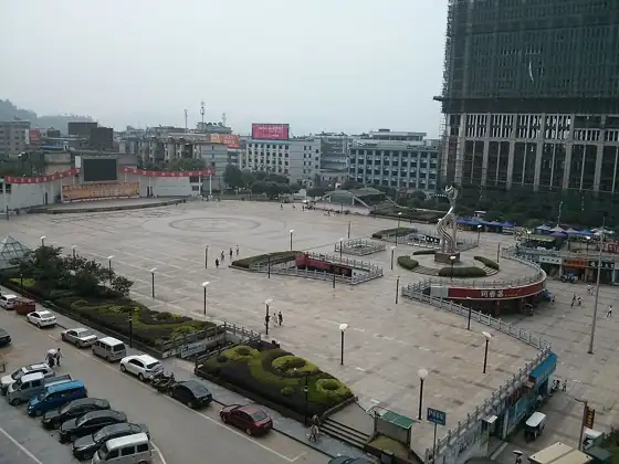
Photo adjustments
Resized and WebP compressed; subject not altered.
- Administrative area
- County · 县
- Part of
- Guilin
- Chinese name
- 全州县
- Local areas
- County guide
Area & population
- Area in the source
- 4,021.00 km²
- Population · 2010
- 803,495
- Administrative seat
- Quanzhou Town
Source: cited geographic source, as of the dates shown.
Setting and landscape
Quanzhou County is Guilin's largest county by area, about 4,021 square kilometres. The Xiang River, the Hunan–Guangxi railway, the Quanzhou–Nanning expressway and National Highway 322 all cross it, and it is the gateway from the central plains into Guangxi. In the mountains are the Tianhu Reservoir (天湖水库) and the Tianhu hydropower station (天湖电站), which has a head of 1,074 metres.
History
For long periods the area was governed together with the lower Xiang valley, under Lingling (零陵郡) and Yongzhou (永州). The Ma family's kingdom of Chu split Quanzhou off from Yongzhou in the Five Dynasties period, and in 1394, under the Ming, it was transferred to Guilin prefecture in Guangxi. Its common speech belongs to the Yongzhou group of Xiang Chinese and is very close to the speech of Lingling (零陵区) in Hunan. Between 25 November and 2 December 1934 the Central Red Army crossed the Xiang River between Xing'an and Quanzhou and fought at Jiaoshanpu (脚山铺) in Quanzhou; the Xiang River battle sites, spread over three counties, became a national key cultural relics site in 2006.
What to see
Xiangshan Temple (湘山寺) on Xiang Hill (湘山), at the west edge of the county town, was founded in 756 by the monk Quanzhen (全真) and burned when Japanese troops left Quanzhou in 1945. Its site, which includes the Miaoming Pagoda (妙明塔), a relic stupa and the Xiangshan rock inscriptions, became a Guangxi protected site in 1994, and its pagodas and inscriptions, dated from the Song to the Qing, are now on the national list. Yanwo Lou (燕窝楼), a Ming–Qing building in Shitougang village (石头岗村), is also a national key site. The Guilin city government counts the Yanjing hot spring (炎井温泉) among the region's visitor attractions.
Food and local products
Local specialities include red-oil rice noodles (红油米粉), duck with black vinegar and blood (黑醋血鸭) and rice-field carp (禾花鱼), which was once sent as tribute to the Qing court. Xiangshan liquor (湘山酒) holds national geographical-indication status.
Highlights
- Xiangshan Temple 湘山寺: Founded in 756 and burned in 1945; its pagodas and rock inscriptions are a national key cultural relics site.
- Xiang River battle sites 湘江战役旧址: National key site since 2006, including the 1934 battlefield at Jiaoshanpu in Quanzhou.
- Tianhu Reservoir 天湖水库: Mountain reservoir; the county also has the Tianhu hydropower station, with a 1,074-metre head.
- Rice-field carp 禾花鱼: Local fish once sent as tribute to the Qing court.
Sources for this guide
全州县 - 维基百科,自由的百科全书 · Wikipedia (Chinese) · CC BY-SA 4.0
湘山寺遗址 - 维基百科,自由的百科全书 · Wikipedia (Chinese) · CC BY-SA 4.0
全州县各级文物保护单位列表 - 维基百科,自由的百科全书 · Wikipedia (Chinese) · CC BY-SA 4.0
湘江战役旧址 - 维基百科,自由的百科全书 · Wikipedia (Chinese) · CC BY-SA 4.0
水文景观 - 桂林市人民政府 · Guilin Municipal People's Government
Original English written from the listed sources and checked sentence by sentence against quoted extracts by a separate reviewer. Updated 2026-09-25.
Explore Quanzhou County
Core places to explore, with English and Chinese names.
Places to explore around Quanzhou County
 Xiangshan Temple · 湘山寺
Xiangshan Temple湘山寺
Quanzhou’s Xiangshan Temple occupies the foot of Xiangshan on the western side of the old county town. Miaoming Pagoda gives the complex a clear vertical landmark, while the Shoufo and Yuantong halls provide the principal…
Read the place guide → Quanzhou Tianhu Lake · 全州天湖
Quanzhou Tianhu Lake全州天湖
Quanzhou Tianhu is a highland landscape of connected reservoirs, grassland and forest on the eastern side of Zhenbaoding. Open water and rounded grassy slopes create a different scene from Guilin’s steep limestone towers. The…
Read the place guide → AI illustration · AI 示意图(仅供参考,非该地点实拍)
Tianhu Lakes天湖
Tianhu (天湖) is a group of high-mountain lakes and reservoirs in the northwest of Quanzhou County, Guilin, Guangxi, lying between 1,400 and 1,800 metres on the eastern side of Zhenbaoding in the Yuecheng Ling range and protected as the Guangxi Quanzhou Tianhu National Wetland Park.
Read the place guide →Local life & food
Quanzhou County local specialties
全州县特色美食 · 2 specialties to discover
 Quanzhou braised rice-field fish 全州黄焖禾花鱼AI illustration · AI 示意图
The fish has tender flesh and a concentrated coating, with many small bones that require care.
Source ↗Read the dish guide →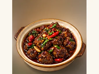 Quanzhou vinegar-blood duck 全州醋血鸭AI illustration · AI 示意图
The flavor is savory, tangy and often spicy, with rich duck meat beneath the sauce. Chili and acidity vary between kitchens.
Source ↗Read the dish guide →All dish names · 全部菜名 (2)
More dishes from across Guangxi are in the Guangxi food guide.
Plan your visit
Getting there
Quanzhou County is about 105 km in a straight line from central Guilin. Search for 全州县 in a map app to find stations and your accommodation.
Where to stay →Build your route
Xiangshan Temple and Quanzhou Tianhu Lake are about 30 km apart in a straight line. The linked place guides have entrance and visit details.
Continue with Guilin →More in Guilin
Sources & geographic information
Administrative names and parent areas: Official geographic directory · Reference date 2026-09-06.
Some facts checked against 全州县 — Wikipedia contributors, CC BY-SA 4.0.
Some facts checked against 湘山寺遗址 — Wikipedia contributors, CC BY-SA 4.0.
Some facts checked against 全州县各级文物保护单位列表 — Wikipedia contributors, CC BY-SA 4.0.
Some facts checked against 湘江战役旧址 — Wikipedia contributors, CC BY-SA 4.0.
Photo: Xiangshan Temple · Augoustoshai · CC BY-SA 4.0. EXIF orientation normalized; resized without changing aspect ratio; converted to WebP. No subject edits.

Photo: Quanzhou Tianhu Lake · Source photographer · License not provided. EXIF orientation normalized; resized without changing aspect ratio; converted to WebP. No subject edits.
Map data © OpenStreetMap contributors. Pins mark approximate centres, not entrances or boundaries.