


Get to know Datong District
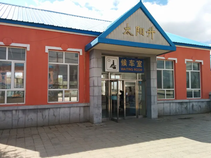
Photo adjustments
Full frame retained; proportionally resized and converted to WebP. No retouching or changes to the photographed subject. Card displays may crop the view.
- Administrative area
- District · 市辖区
- Part of
- Daqing
- Chinese name
- 大同区
- Local areas
- District guide
Area & population
- Area in the source
- 2,235.00 km²
- Population · 2003
- 250,000
- Administrative seat
- Qingpu Subdistrict (庆葡街道)
Source: cited geographic source, as of the dates shown.
History
In October 1958 the Songliao petroleum exploration bureau sited a test well, Songji No. 3 (松基三井), at Datong town (大同镇), then part of Zhaozhou County (肇州县). On 26 September 1959 the well produced a commercial flow of oil. That November the provincial party secretary Ouyang Qin (欧阳钦) proposed renaming the town Daqing, "great celebration", to mark a discovery made in the tenth anniversary year of the People's Republic, and the new field took the same name. Datong town remains one of the district's towns.
The well stands beside Yongyue village (永跃村) in Gaotaizi town (高台子镇). It was listed as a national key cultural relics protection unit in 2001; it was drilled to 1,461.76 metres and has produced about 10,100 tonnes of crude in total.
Setting and landscape
The district government puts the area at 2,400 square kilometres, with 1.32 million mu of cropland, 635,000 mu of grassland, 470,000 mu of water surface and 365,000 mu of woodland. Datong lies in the Aogula wind gap (敖古拉大风口), where the average wind speed is 4.1 metres per second, and the government describes it as having relatively few days of rain, fog or dust and many clear days. Oilfield production plants No. 5, 7 and 8 and the Xinhua power station (新华电厂) operate in the district.
Food and local products
Greenhouse vegetables and fruit are the focus of local farming, alongside 121,000 mu of millet, sorghum and other coarse grains. The district government calls Datong the country's largest production base for banlangen (板蓝根, isatis root), grown with evening primrose and white peony root on 70,000 mu of medicinal-herb fields, and reports the largest large-scale dairy goat base in China.
Datong's third district-level intangible heritage list (2025) includes pit roasting from Bajingzi township (八井子乡坑烤), cold-region dried tofu (寒地干豆腐), two baijiu distilling techniques, paper-cutting and gourd pyrography. Pit roasting means cooking food in a hole dug in the ground; during the oilfield campaign, workers used it to roast potatoes on open wasteland during breaks.
Getting oriented
The Daguang Expressway (大广高速) crosses the district. The Sada road (萨大路) runs north to south through the city, the Tongchang road (同昌路) leads to the provincial capital, Harbin, and the Anmin road (安民路) is the route out of the province towards Jilin and Liaoning. Seven passenger and freight stops of the Harbin and Shenyang railway bureaus lie in the district.
Highlights
- Songji No. 3 Well 松基三井: Discovery well of the Daqing oilfield, which struck oil on 26 September 1959; a national key cultural relics protection unit since 2001.
- Bajingzi pit roasting 八井子乡坑烤: On Datong District's 2025 intangible heritage list; food is roasted in a pit dug in the ground.
- Banlangen (isatis root) 板蓝根: The district government calls Datong the largest banlangen production base in China.
Sources for this guide
大同概况 (Datong overview) · Datong District People's Government, Daqing
资源概况 (Resources overview) · Datong District People's Government, Daqing
大庆市大同区人民政府关于公布第三批区级非物质文化遗产代表性项目名录的通知 · Datong District People's Government, Daqing
大庆市 · Wikipedia (Chinese) · CC BY-SA 4.0
松基三井 · Wikipedia (Chinese) · CC BY-SA 4.0
大同区 (大庆市) · Wikipedia (Chinese) · CC BY-SA 4.0
Original English written from the listed sources and checked sentence by sentence against quoted extracts by a separate reviewer. Updated 2026-09-24.
Explore Datong District
Core places to explore, with English and Chinese names.
Datong District 大同区
Plan your visit
Getting there
Datong District is about 75 km in a straight line from central Daqing. Search for 大同区 in a map app to find stations and your accommodation.
Where to stay →More in Daqing
Sources & geographic information
Administrative names and parent areas: Official geographic directory · Reference date 2026-09-06.
Some facts checked against 大庆市 — Wikipedia contributors, CC BY-SA 4.0.
Some facts checked against 松基三井 — Wikipedia contributors, CC BY-SA 4.0.
Some facts checked against 大同区 (大庆市) — Wikipedia contributors, CC BY-SA 4.0.
Map data © OpenStreetMap contributors. Pins mark approximate centres, not entrances or boundaries.