


Get to know Ranghulu District
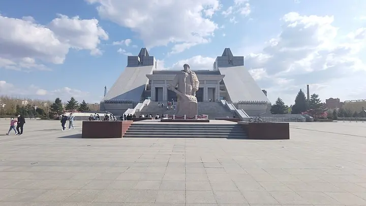
Photo adjustments
Full frame retained; proportionally resized and converted to WebP. No retouching or changes to the photographed subject. Card displays may crop the view.
- Administrative area
- District · 市辖区
- Part of
- Daqing
- Chinese name
- 让胡路区
- Local areas
- District guide
Area & population
- Area in the source
- 1,394.00 km²
- Population · 2018
- 480,857
Source: cited geographic source, as of the dates shown.
History
The district takes its name from a railway station. Building of the stop began in August 1898 with the Chinese Eastern Railway, and it opened in July 1903 as Stop No. 52, later called Suolongchaqi (索龙察奇). In 1960, to take pressure off Sartu (萨尔图) station, it was renamed Ranghulu, written with the character for "lake" (让湖路). The station was renamed Daqing West (大庆西站) on 26 October 2013, while the district keeps a slightly different spelling of the old name, using a different character for "hu".
What to see
The Iron Man Wang Jinxi Memorial Hall (铁人王进喜纪念馆) honours Wang Jinxi, who led the 1205 drilling team and is remembered as the "Iron Man" hero of the Daqing oilfield's development. Xinhua lists it as a national 4A-rated scenic area and a national first-grade museum. It began in 1971 as an exhibition room; the present hall, on Tieren Avenue (铁人大道) at Century Avenue (世纪大道), opened on 26 September 2006, the 47th anniversary of the oilfield's discovery. From above the main building forms the character for "work" (工) and from the side the character for "person" (人); it is 47 metres high with 47 front steps, one for each year of Wang's life, and the roof is shaped like a drill bit.
Chinese Wikipedia records 5,324 items in the collection. Displays follow Wang's life alongside the history of Daqing oil, with more than 200 photographs and 300 objects, among them his aluminium helmet, his motorcycle and the padded work jacket he wore when he jumped into a mud pit to stop a blowout. The grounds hold a 6.5-metre granite statue of Wang holding a brake lever and a Soviet-made BU-40 drilling rig of the same model his team used.
Getting oriented
Daqing West station, with a new building opened in November 2013, is served by the Binzhou (滨洲铁路) and Tongrang (通让铁路) railways and the Harbin–Qiqihar high-speed railway, whose platforms opened in August 2015. China National Highway 301 passes through the district. The district government sits in Longgang (龙岗) subdistrict, and Lamadian (喇嘛甸镇) is its one town.
Highlights
- Iron Man Wang Jinxi Memorial Hall 铁人王进喜纪念馆: A national 4A scenic area and first-grade museum on the life of Wang Jinxi and the history of Daqing oil, opened in its present building in 2006.
- Daqing West Railway Station 大庆西站: The former Ranghulu station, first opened in 1903, now also served by the Harbin–Qiqihar high-speed railway.
Sources for this guide
让胡路区 · Wikipedia (Chinese) · CC BY-SA 4.0
大庆西站 · Wikipedia (Chinese) · CC BY-SA 4.0
多彩大庆|铁人王进喜纪念馆 · Xinhua News Agency (Heilongjiang channel)
大庆铁人王进喜纪念馆 · Wikipedia (Chinese) · CC BY-SA 4.0
Original English written from the listed sources and checked sentence by sentence against quoted extracts by a separate reviewer. Updated 2026-09-24.
Explore Ranghulu District
Core places to explore, with English and Chinese names.
Places to explore around Ranghulu District
Plan your visit
Getting there
Ranghulu District is about 20 km in a straight line from central Daqing. Search for 让胡路区 in a map app to find stations and your accommodation.
Where to stay →Build your route
Start with Iron Man Wang Jinxi Memorial Hall. The linked place guides have entrance and visit details.
Continue with Daqing →More in Daqing
Sources & geographic information
Administrative names and parent areas: Official geographic directory · Reference date 2026-09-06.
Some facts checked against 让胡路区 — Wikipedia contributors, CC BY-SA 4.0.
Some facts checked against 大庆西站 — Wikipedia contributors, CC BY-SA 4.0.
Some facts checked against 大庆铁人王进喜纪念馆 — Wikipedia contributors, CC BY-SA 4.0.
Photo: Iron Man Wang Jinxi Memorial Hall · Fghjhj · Fghjhj — 大庆市照片.jpg — CC BY-SA 4.0 · CC BY-SA 4.0. Full frame retained; proportionally resized and converted to WebP. No retouching or changes to the photographed subject. Card displays may crop the view.

Map data © OpenStreetMap contributors. Pins mark approximate centres, not entrances or boundaries.