


Get to know Fuyuan
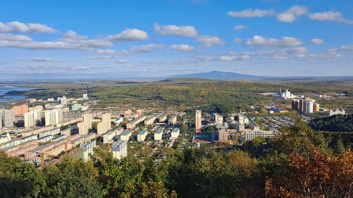
Photo adjustments
Full frame retained; proportionally resized and converted to WebP. No retouching or changes to the photographed subject. Card displays may crop the view.
- Administrative area
- County-level city · 县级市
- Part of
- Jiamusi
- Chinese name
- 抚远市
- Local areas
- County-level city guide
Area & population
- Area in the source
- 6,260.00 km²
- Population · 2010
- 126,694
Source: cited geographic source, as of the dates shown.
Setting and landscape
Fuyuan sits on low alluvial plain, with plains at roughly 37 to 60 metres above sea level; its highest point is Liangjia Mountain (两夹山) at 279.1 metres. Rivers, lakes, ponds and marshes are spread across the city, and the larger local rivers include the Fuyuan Channel (抚远水道), the Nongjiang (浓江河) and the Bielahong (别拉洪河). The Amur and Ussuri form its 212-kilometre border with Russia. Summers are short and hot, winters long and severe, springs windy and summers wet.
The city seat, Fuyuan Town, stands on the south bank of the Amur, facing Russia's Jewish Autonomous Region across the water; Khabarovsk lies about 50 kilometres east of Fuyuan Town.
History
The city government describes Fuyuan as one of the homelands of the Sushen (肃慎), forerunners of the Manchu. Its old name, Yiliga (伊力嘎), means 'golden fish shoal' in the Hezhe (赫哲) language. A Suiyuan sub-prefecture (绥远州) was set up here in 1909, and the county took the name Fuyuan in 1929. In April 1951 the county was replaced by the Fuyuan Fishing Special District, which reverted to a county in August 1952. A border settlement with Russia, concluded on 14 October 2008, gave Fuyuan part of Heixiazi Island, and on 15 January 2016 the county became a county-level city under Jiamusi.
What to see
Heixiazi Island (黑瞎子岛), called Bolshoy Ussuriysky Island in Russian, lies in the city's north-east at the Amur-Ussuri confluence. Its Manchu name, morin uju, translates as 'horse-head island'. Fuyuan records say the Ming eunuch Yishiha (亦失哈) led large fleets past the island ten times between 1411 and 1433 on inspections of the lower Amur, and the Qing set up a border post at its north-east corner in 1854.
On the island, the bear park (探秘野熊园), opened in 2017, is driven through by vehicle and holds more than 120 Asian black bears along with roe deer, wild boar and foxes; the city government calls it China's largest black-bear-themed scenic area. A wetland park crosses the island's marshes on a boardwalk 2,256 metres long, and the Dongji Pagoda (东极宝塔), a nine-storey octagonal tower 81 metres high in Han and Tang style, marks China's eastern extremity.
Food and local products
Fuyuan grows rice, soybeans, cranberries and maize, geese are its main livestock, and its fish farms raise sturgeon used for caviar.
Highlights
- Heixiazi Island 黑瞎子岛: Island at the Amur-Ussuri confluence, part of which passed to Fuyuan under the 2008 border settlement with Russia.
- Dongji Pagoda 东极宝塔: Nine-storey octagonal tower, 81 metres high, built as the landmark of China's eastern extremity.
- Bear park 探秘野熊园: Drive-through park on Heixiazi Island with more than 120 Asian black bears, opened in 2017.
Sources for this guide
走进抚远 · Fuyuan City People's Government
黑瞎子岛 · Fuyuan City People's Government
Fuyuan, Heilongjiang · Wikipedia · CC BY-SA 4.0
Original English written from the listed sources and checked sentence by sentence against quoted extracts by a separate reviewer. Updated 2026-09-24.
Explore Fuyuan
Core places to explore, with English and Chinese names.
Places to explore around Fuyuan
 AI illustration · AI 示意图(仅供参考,非该地点实拍)
Heixiazi Island Scenic Area黑瞎子岛开放旅游区
The Chinese visitor area of Heixiazi Island in Fuyuan pairs wetland scenery with Dongji Pagoda on an island shared by China and Russia.
Read the place guide →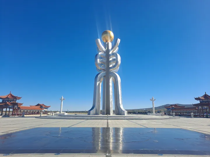 The monumental sundial-form sculpture at Dongji Square, Fuyuan · 抚远东极广场地标雕塑 Source-recorded photograph date: 2025-09-29 10:01:05.
Dongji Square东极广场
Dongji Square marks Fuyuan's eastern river landscape with a tall sculpture based on the seal-script character for east. A golden sphere suggests the sun above it, while a large marble map of China forms the base. The surrounding…
Read the place guide →Plan your visit
Getting there
Fuyuan is about 345 km in a straight line from central Jiamusi. Search for 抚远市 in a map app to find stations and your accommodation.
Where to stay →Build your route
Heixiazi Island Scenic Area and Dongji Square are both listed here. The linked place guides have entrance and visit details.
Continue with Jiamusi →More in Jiamusi
Sources & geographic information
Administrative names and parent areas: Official geographic directory · Reference date 2026-09-06.
Some facts checked against Fuyuan, Heilongjiang — Wikipedia contributors, CC BY-SA 4.0.
Photo: Dongji Square · H2v5o68z · CC0. Full frame retained; proportionally resized and converted to WebP. No retouching or changes to the photographed subject. Card displays may crop the view.

Map data © OpenStreetMap contributors. Pins mark approximate centres, not entrances or boundaries.