


Get to know Dongning

Photo adjustments
EXIF orientation normalized; resized without changing aspect ratio; converted to WebP. No subject edits.
- Administrative area
- County-level city · 县级市
- Part of
- Mudanjiang
- Chinese name
- 东宁市
- Local areas
- County-level city guide
Area & population
- Area in the source
- 7,368.00 km²
- Population · 2003
- 210,000
Source: cited geographic source, as of the dates shown.
Setting and landscape
The Suifen River (绥芬河) runs through the whole city. A maritime influence keeps the average temperature around 6°C, with no severe winter cold or summer heat, which earns Dongning the nickname "little Jiangnan beyond the northern frontier". Forest covers most of the land. There are two national wetland parks, on the Suifen River and at Suiyang (绥阳), and the provincial Niaoqingshan Nature Reserve (鸟青山自然保护区). Part of the Northeast China Tiger and Leopard National Park lies here; the Mudanjiang city government reports that monitoring has recorded 15 wild Amur tigers and 22 Amur leopards.
History
Traces of people go back some ten thousand years to the Palaeolithic, and more than 20 sites from the Qin and Han periods have been found. In the 7th century the area belonged to Goguryeo (高句丽) and later to the Bohai kingdom (渤海国). The Qing ran it as Dongning Subprefecture (东宁厅); under the Republic it became Dongning County, locally called Sanchakou (三岔口). The county became a county-level city in December 2015.
Border trade through the Dongning crossing began in 1990, and in 2000 the China–Russia Dongning–Poltavka trade zone (东宁—波尔塔夫卡互市贸易区) was set up.
What to see
Dongning Fortress (东宁要塞) was one of the Japanese army's border fortress complexes in Manchuria, stretching more than 110 kilometres along its front and over 50 kilometres deep; some 170,000 labourers worked on its construction. Soviet forces attacked it on 9 August 1945, and the last Japanese troops inside surrendered only on 30 August, more than two weeks after the Japanese emperor announced surrender on 15 August. The remains of 39 former "comfort stations" have been found within it. In 2006 it was added to the sixth batch of national key protected sites under the name Japanese Army Fortresses in Northeast China (侵华日军东北要塞). The Mudanjiang city government calls it Asia's largest military fortress and the last battlefield of the Second World War.
Food and local products
The rivers and hills supply tantou fish (滩头鱼), chum salmon (大马哈) and matsutake mushrooms (松茸). Black wood ear fungus (黑木耳) has earned Dongning the title of "China's top black fungus county". Soybeans, rice, apples and ginseng are also grown.
Getting oriented
The city government is at Dongning town (东宁镇). The Mudanjiang city government gives distances of 53 kilometres to Ussuriysk and 153 kilometres to Vladivostok in Russia. National Highway 331 passes through.
Highlights
- Dongning Fortress 东宁要塞: Japanese border fortress complex, national key protected site since 2006; its garrison held out until 30 August 1945.
- Suifen River 绥芬河: Runs through the whole city; one of its two national wetland parks lies along it.
- Niaoqingshan Nature Reserve 鸟青山自然保护区: Provincial-level nature reserve.
- Black wood ear fungus 黑木耳: Has earned Dongning the title of China's top black fungus county.
Sources for this guide
东宁市 · Chinese Wikipedia · CC BY-SA 4.0
东宁市概况 · Mudanjiang Municipal People's Government
侵华日军东北要塞 · Chinese Wikipedia · CC BY-SA 4.0
Original English written from the listed sources and checked sentence by sentence against quoted extracts by a separate reviewer. Updated 2026-09-24.
Explore Dongning
Core places to explore, with English and Chinese names.
Places to explore around Dongning
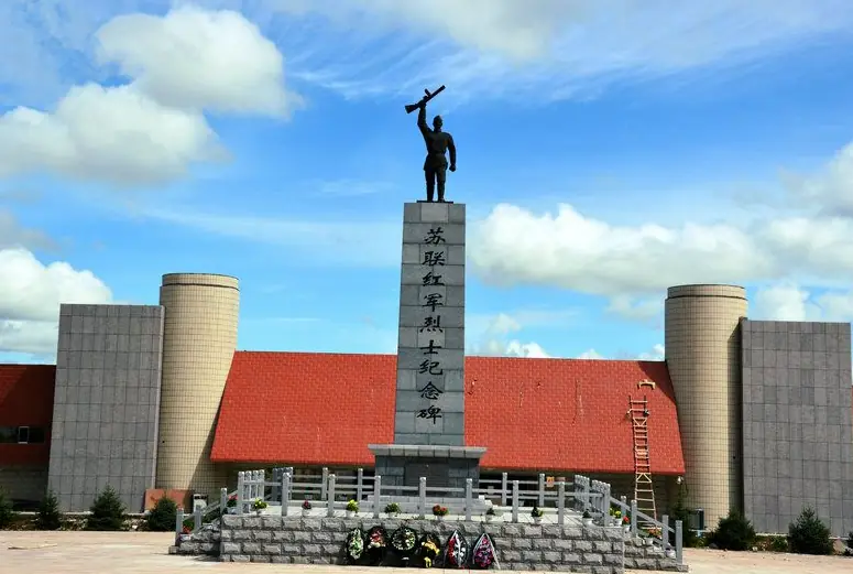 Dongning Fortress Ruins ·
 Plan your visit
Getting there
Dongning is about 105 km in a straight line from central Mudanjiang. Search for 东宁市 in a map app to find stations and your accommodation.
Where to stay →Build your route
Start with Dongning Fortress Ruins. The linked place guides have entrance and visit details.
Continue with Mudanjiang →More in Mudanjiang
Sources & geographic information
Administrative names and parent areas: Official geographic directory · Reference date 2026-09-06.
Some facts checked against 东宁市 — Wikipedia contributors, CC BY-SA 4.0.
Some facts checked against 侵华日军东北要塞 — Wikipedia contributors, CC BY-SA 4.0.
Photo: Dongning Fortress Ruins · Source photographer · License not provided. EXIF orientation normalized; resized without changing aspect ratio; converted to WebP. No subject edits.
Map data © OpenStreetMap contributors. Pins mark approximate centres, not entrances or boundaries.