


Get to know Luolong District
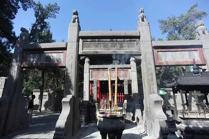
Photo adjustments
Full frame retained; resized proportionally to a maximum dimension of 960 pixels and converted to WebP quality 88. No crop, retouch, generated elements, or subject alteration. Final website rendition: full frame retained, proportionally resized to at most 720 pixels and converted to WebP. No additional retouching or subject alteration. Card displays may crop the view.
- Administrative area
- District · 市辖区
- Part of
- Luoyang
- Chinese name
- 洛龙区
- Local areas
- District guide
Area & population
- Area in the source
- 271.00 km²
- Population · 2023
- 719,600
Source: cited geographic source, as of the dates shown.
Setting and landscape
The district sits on the alluvial plain of the Yi and Luo rivers (伊洛河). The ground is higher in the north-west and falls away to the south-east, and bedrock breaks the surface mainly in the southern hills and the Longmen hills.
History
Luolong began as Luoyang's suburban district and took its present name in 2000 with State Council approval. The district government now describes it as the city's administrative centre as well as its economic, cultural and sports centre, and the shopping area around Kaiyuan Lake (开元湖) has been named a Henan cluster for night-time culture and tourism.
What to see
The Longmen Grottoes line the cliffs of Longmen Hill (龙门山) and Xiangshan (香山) on both banks of the Yi River (伊水), 12 kilometres into Luoyang's southern outskirts. Most of the carving was done over more than four centuries from the Northern Wei to the Northern Song, after Emperor Xuanwu of the Northern Wei (魏宣武帝) ordered statues cut at Longmen in 500; over 2,100 caves and niches, more than 100,000 statues and about 3,600 inscriptions survive, mostly on the west bank. The 'Twenty Pieces of Longmen' (龙门二十品) are prized examples of Wei-style calligraphy. UNESCO inscribed the site in 2000.
Guanlin (关林), in the district's Guanlin subdistrict, is by tradition the burial place of the head of Guan Yu (关羽), the general of Liu Bei (刘备), which Cao Cao (曹操) is said to have buried with the rites of a prince in 220. The present complex of Ming and Qing buildings, rebuilt in 1592, combines a tomb mound, a temple and a grove; it is a national key protected site and a 4A scenic area.
The Luoyang Museum (洛阳博物馆), a national first-grade museum, was founded in 1958 with the Guanlin temple as its first home, and its new building in Luolong opened on 16 April 2011. It displays more than 11,000 objects, and its collection runs from the Yangshao and Longshan cultures and the Xia and Shang through to the Ming, Qing and Republican eras.
Highlights
- Longmen Grottoes 龙门石窟: Caves carved mainly from the Northern Wei to the Northern Song on both banks of the Yi River; World Heritage since 2000.
- Guanlin 关林: Traditional burial place of Guan Yu's head; Ming and Qing temple complex rebuilt in 1592.
- Luoyang Museum 洛阳博物馆: National first-grade museum; new Luolong building opened in 2011 with over 11,000 objects on display.
Sources for this guide
洛龙概况_洛龙概况_洛龙区人民政府 · Luolong District People's Government, Luoyang
洛龙区 - 维基百科,自由的百科全书 · Chinese Wikipedia · CC BY-SA 4.0
龙门石窟 - 维基百科,自由的百科全书 · Chinese Wikipedia · CC BY-SA 4.0
关林 - 维基百科,自由的百科全书 · Chinese Wikipedia · CC BY-SA 4.0
洛阳博物馆 - 维基百科,自由的百科全书 · Chinese Wikipedia · CC BY-SA 4.0
Original English written from the listed sources and checked sentence by sentence against quoted extracts by a separate reviewer. Updated 2026-09-25.
Explore Luolong District
Core places to explore, with English and Chinese names.
Places to explore around Luolong District
 The main gate of Guanlin Temple in Luoyang; 30 November 2025.
Guanlin关林
Guanlin in Luoyang’s Luolong district is traditionally identified as the burial place of Guan Yu’s head. Its historical complex combines tomb, temple and commemorative grove.
Read the place guide →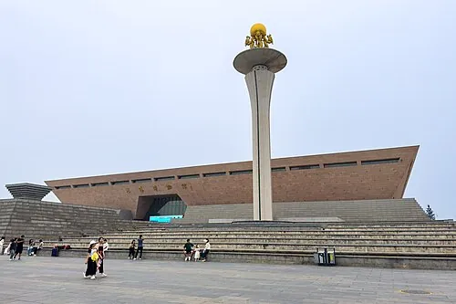 Exterior of Luoyang Museum at its Nietai Road site · 洛阳博物馆聂泰路馆址外观. Source-recorded photograph date: 2024-09-29 15:15:42.
Luoyang Museum洛阳博物馆
Luoyang history museum in a ding-shaped building, tracing the city's five capitals from prehistory to the Northern Song.
Read the place guide →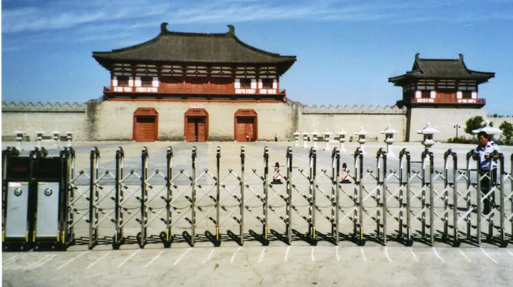 The reconstructed Dingding Gate of Sui-Tang Luoyang City, Luoyang · 洛阳隋唐洛阳城定鼎门遗址博物馆复建城楼 Source-recorded photograph date: 2012-10-11 10:09:06.
Sui and Tang Luoyang City Dingding Gate Site Museum隋唐洛阳城定鼎门遗址博物馆
Museum over the Sui-Tang main gate of Luoyang, in use for about 530 years, with excavated remains below and a rebuilt Tang-style gate above.
Read the place guide →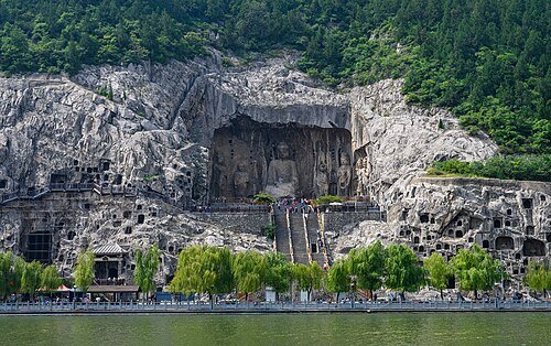 Longmen Grottoes · 龙门石窟
Longmen Grottoes龙门石窟
Longmen’s Buddhist figures occupy limestone cliffs on both sides of the Yi River, with the densest sequence on the west bank. Small niches and inscriptions lead to compositions on a very different scale, especially the great…
Read the place guide →Plan your visit
Getting there
Luolong District covers the centre of Luoyang. Search for 洛龙区 in a map app to find stations and your accommodation.
Where to stay →Build your route
Guanlin and Luoyang Museum are about 5 km apart in a straight line. The linked place guides have entrance and visit details.
Continue with Luoyang →More in Luoyang
Sources & geographic information
Administrative names and parent areas: Official geographic directory · Reference date 2026-09-06.
Some facts checked against 洛龙区 — Wikipedia contributors, CC BY-SA 4.0.
Some facts checked against 龙门石窟 — Wikipedia contributors, CC BY-SA 4.0.
Some facts checked against 关林 — Wikipedia contributors, CC BY-SA 4.0.
Some facts checked against 洛阳博物馆 — Wikipedia contributors, CC BY-SA 4.0.
Photo: Guanlin · Baomi · CC BY-SA 4.0. Proportionally resized and converted to WebP without cropping, retouching or changing the photographed subject.

Photo: Luoyang Museum · Tim Wu · CC BY-SA 4.0. Full source framing retained; proportionally resized and converted to WebP. No retouching or subject alteration. Card displays may crop the view.

Photo: Sui and Tang Luoyang City Dingding Gate Site Museum · Robert Schediwy · CC BY-SA 3.0. Full frame retained; proportionally resized and converted to WebP. No retouching or changes to the photographed subject. Card displays may crop the view.

Photo: Longmen Grottoes · xiquinhosilva · CC BY 2.0. Wikimedia thumbnail; fitted to the ranking-card frame.
.jpg)
Map data © OpenStreetMap contributors. Pins mark approximate centres, not entrances or boundaries.