


Get to know Suiping County
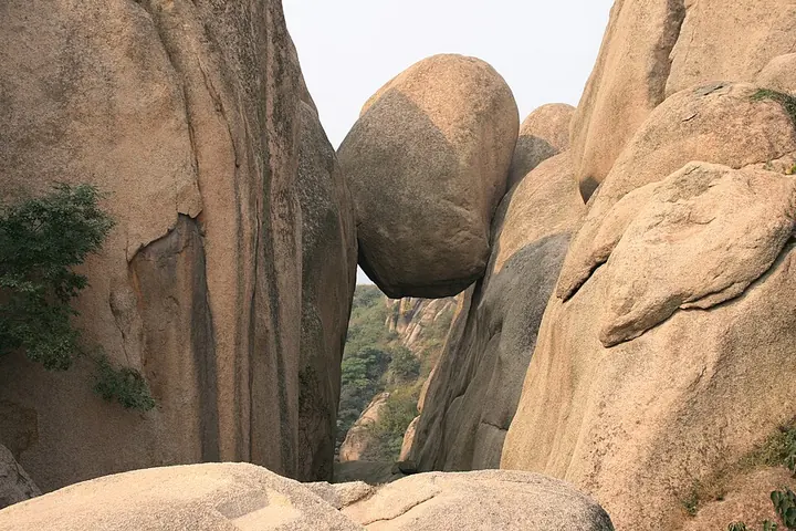
Photo adjustments
Full frame retained; proportionally resized and converted to WebP. No retouching or changes to the photographed subject. Card displays may crop the view.
- Administrative area
- County · 县
- Part of
- Zhumadian
- Chinese name
- 遂平县
- Local areas
- County guide
Area & population
- Area in the source
- 1,080.00 km²
- Population · 2019
- 431,700
Source: cited geographic source, as of the dates shown.
History
The county government describes the area as the ancient Fang (房), the place where the Fang surname began; it was the small state of Fangzi (房子国) under the Western Zhou and was called Wufang (吴房) in the late Spring and Autumn period. In 817, the twelfth year of the Tang Yuanhe reign, the general Li Su (李愬) set out from here on his snowy-night raid on Caizhou (蔡州) that ended the rebellion of Wu Yuanji (吴元济). Emperor Xianzong (唐宪宗) then renamed the county Suiping, meaning that affairs go smoothly and the realm is at peace.
In April 1958 the Chayashan Satellite People's Commune (嵖岈山卫星人民公社) was founded here, which the county government calls the first people's commune in China, and Mao Zedong came to Suiping on an inspection visit. The former commune site is now a museum and a national key protected site. In 2024 the Suiping 1955 Industrial Culture Creative Park (1955工业文化创意园) was listed as provincial industrial heritage in Henan.
What to see
Chaya Mountain belongs to the eastern outliers of the Funiu Mountains (伏牛山). It takes its name from its steep, crowded rocks and is also called Shihou Xianshan (石猴仙山, "Stone Monkey Immortal Mountain") and nicknamed "Central Plains bonsai". The area covers about 148 square kilometres, and in 1987 Henan made it one of its first provincial scenic areas. It is now a national 5A scenic area, a national geopark and a national forest park, and it was a main outdoor filming location for the CCTV television series Journey to the West (西游记).
Around the main scenic area the county lists the former commune museum, the Four Seasons Flower Sea hot-spring town (四季花海温泉小镇), the Hongshiya (红石崖) red cliffs of Danxia landform, the Fengminggu (凤鸣谷) upland wetland and the Longtiangou (龙天沟) valley of waterfalls and springs.
Getting oriented
The Beijing–Hong Kong–Macau Expressway, the Xuchang–Xinyang Expressway, the Beijing–Guangzhou railway, the Beijing–Guangzhou high-speed railway and National Highway 107 all run north to south through the county. The land is mostly flat, with a warm-temperate, semi-humid monsoon climate and about 1,000 millimetres of rain a year; wheat, maize, soybeans and peanuts are the main crops.
Highlights
- Chaya Mountain 嵖岈山: National 5A scenic area and geopark of jagged rock peaks; a main filming location for CCTV's Journey to the West.
- Chayashan Satellite People's Commune site 嵖岈山卫星人民公社旧址: Founded April 1958 and called the first people's commune in China; now a museum and national key protected site.
- Hongshiya 红石崖: Red cliffs of Danxia landform near the Chaya Mountain scenic area.
Sources for this guide
遂平概况_遂平县人民政府 · Suiping County People's Government
嵖岈山 - 维基百科,自由的百科全书 · Wikipedia (Chinese) · CC BY-SA 4.0
Original English written from the listed sources and checked sentence by sentence against quoted extracts by a separate reviewer. Updated 2026-09-24.
Explore Suiping County
Core places to explore, with English and Chinese names.
Places to explore around Suiping County
Plan your visit
Getting there
Suiping County is about 15 km in a straight line from central Zhumadian. Search for 遂平县 in a map app to find stations and your accommodation.
Where to stay →Build your route
Start with Chaya Mountain. The linked place guides have entrance and visit details.
Continue with Zhumadian →More in Zhumadian
Sources & geographic information
Administrative names and parent areas: Official geographic directory · Reference date 2026-09-06.
Some facts checked against 嵖岈山 — Wikipedia contributors, CC BY-SA 4.0.
Photo: Chaya Mountain · Gary Todd · CC0. Full frame retained; proportionally resized and converted to WebP. No retouching or changes to the photographed subject. Card displays may crop the view.

Map data © OpenStreetMap contributors. Pins mark approximate centres, not entrances or boundaries.