


Get to know Islands District
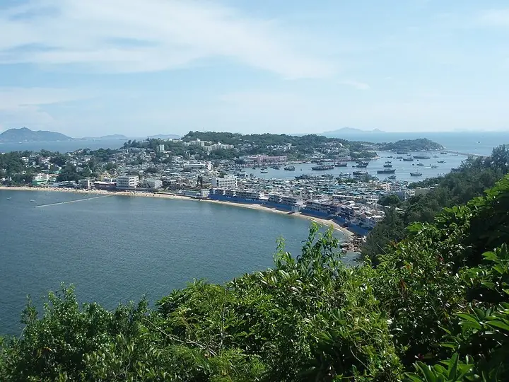
Photo adjustments
The exact downloaded source bytes are separately retained and hashed. Prepared JPEG is proportionally reduced to a maximum 720-pixel long edge; full frame retained, no subject alteration. Final website rendition: full frame retained, proportionally resized to at most 720 pixels and converted to WebP. No additional retouching or subject alteration. Card displays may crop the view.
- Administrative area
- District · 地區
- Part of
- Hong Kong
- Chinese name
- 離島
- Local areas
- District guide
Area & population
- Area in the source
- 175.03 km²
Source: cited geographic source, as of the dates shown.
Setting and landscape
Lantau, about 148 sq km, has 47 settlements, chief among them Mui Wo (梅窩), Tung Chung and Tai O (大澳). Its north carries Hong Kong International Airport at Chek Lap Kok (赤鱲角), the Hong Kong–Zhuhai–Macao Bridge and the cable car from Tung Chung to Ngong Ping (昂坪). More than half the island lies in country parks, crossed by the 70-km Lantau Trail, a loop that starts and ends in Mui Wo. North Lantau changed after the airport moved to Chek Lap Kok in the 1990s; south Lantau and the smaller islands remain rural.
History
Finds at Fu Tei Wan on Chek Lap Kok and on Lamma point to settlers in the Middle Neolithic (about 4000–2500 BC). Rock carvings on Cheung Chau (長洲), declared monuments in 1982, may date from the Bronze Age. Tung Chung Fort (東涌炮台), probably built in 1832 against pirates, keeps six old cannons and was declared a monument in 1979.
What to see
Po Lin Monastery (寶蓮禪寺) at Ngong Ping began in 1906 as the "Big Thatched Hut" and took its present name in 1924. In front of it, the Big Buddha (天壇大佛), cast from 250 tonnes of bronze and opened in 1993, sits on Mount Muk Yue (木魚山) above 268 steps. At Tai O, stilt houses line the narrow channels; each year on the 4th and 5th days of the 5th lunar month, dragon boats tow deity statues from four temples through the waterways, a festival on the national intangible heritage list since 2011.
Cheung Chau, a dumbbell-shaped island of 2.44 sq km, holds its Jiao Festival (太平清醮), also nationally listed in 2011, with a parade and a midnight bun-scrambling contest. On Lamma (南丫島), Sham Wan (深灣) is Hong Kong's only known nesting site for green turtles. Peng Chau (坪洲) has a Tin Hau temple of 1792 holding a five-foot fish bone and a former leather factory now used as an arts space.
Food and local products
Tai O is known for shrimp paste and salted fish. On Lamma, a 7-km trail links Yung Shue Wan (榕樹灣) and Sok Kwu Wan (索罟灣), both popular for seafood.
Highlights
- Big Buddha and Po Lin Monastery 天壇大佛: Bronze statue opened in 1993 before a monastery founded in 1906.
- Tai O 大澳: Stilt-house fishing village with a dragon-boat water parade.
- Cheung Chau Jiao Festival 太平清醮: Parade and midnight bun-scrambling; nationally listed in 2011.
- Tung Chung Fort 東涌炮台: Probably built in 1832; six old cannons remain.
- Lantau Trail 鳳凰徑: 70-km loop from Mui Wo through the Lantau country parks.
Sources for this guide
Hong Kong Fun in 18 Districts - Islands District · Home Affairs Department, HKSAR Government
Hong Kong Fun in 18 Districts - Lantau Island · Home Affairs Department, HKSAR Government
Hong Kong Fun in 18 Districts - Po Lin Monastery and The Big Buddha · Home Affairs Department, HKSAR Government
Hong Kong Fun in 18 Districts - Tai O · Home Affairs Department, HKSAR Government
Hong Kong Fun in 18 Districts - Cheung Chau · Home Affairs Department, HKSAR Government
Hong Kong Fun in 18 Districts - Tung Chung Fort · Home Affairs Department, HKSAR Government
Hong Kong Fun in 18 Districts - Lamma Island · Home Affairs Department, HKSAR Government
Hong Kong Fun in 18 Districts - Peng Chau · Home Affairs Department, HKSAR Government
Original English written from the listed sources and checked sentence by sentence against quoted extracts by a separate reviewer. Updated 2026-09-25.
Explore Islands District
Core places to explore, with English and Chinese names.
Cheung Chau 长洲
Hong Kong International Airport 香港國際機場
Lamma Island 南丫岛
Mui Wo 梅窝
Ngong Ping 360 · Ngong Ping terminal 昂坪360·昂坪端站
Peng Chau 坪洲
Po Lin Monastery 宝莲禅寺
Tai O Fishing Village 大澳
Tian Tan Buddha 天坛大佛
Tung Chung Fort 东涌炮台
Ngong Ping 360, Tian Tan Buddha and Po Lin Monastery 昂坪360与天坛大佛宝莲禅寺
Hong Kong Disneyland 香港迪士尼乐园
Mui Wo and Silvermine Bay 梅窝与银矿湾
Places to explore around Islands District
Cheung Chau town and twin coasts viewed from the north · 从北侧俯瞰长洲市区与两岸 Photograph date recorded by the source: 12 August 2013, 09:12:12.Cheung Chau长洲
Cheung Chau offers a clear contrast between its working ferry waterfront, temple streets and eastern beach. Pak Tai Temple on Pak She Street rewards a close look at roof dragons and carved granite dragon pillars. Across the…
Read the place guide →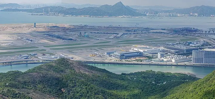 Hong Kong International Airport island and runways · 香港国际机场机场岛与跑道 Photograph date recorded by the source: 21 July 2023, 15:50:15.
Hong Kong International Airport香港國際機場
Hong Kong International Airport offers two very different spaces worth noticing during a journey. The South Waterfall Garden uses digital imagery to create an interactive creek, pond and waterfall within the public terminal…
Read the place guide →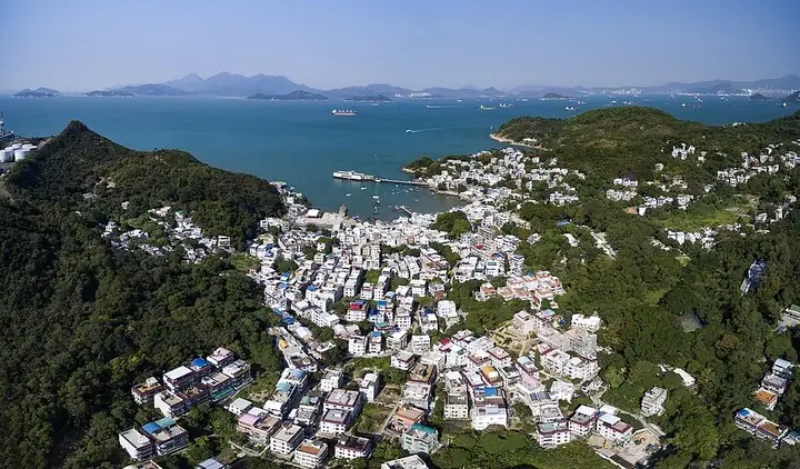 Yung Shue Wan on Lamma Island · 南丫岛榕树湾 Photograph date recorded by the source: 17 December 2015, 10:31:32.
Lamma Island南丫岛
Lamma’s two main ferry villages provide different ends to an island outing. Yung Shue Wan has a compact commercial street and a Tin Hau Temple guarded by stone lions. The Family Walk continues by Hung Shing Yeh Beach towards Sok…
Read the place guide → Mui Wo and Silver Mine Bay viewed from the hillside · 梅窝与银矿湾山坡远景 Photograph date recorded by the source: 24 January 2021, 13:18:56.
Mui Wo梅窝
Mui Wo’s waterfront makes a manageable introduction to eastern Lantau. Silvermine Bay Promenade runs between the Cooked Food Market and Silvermine Bay Beach, with open water on one side and the town’s daily activity nearby. The…
Read the place guide →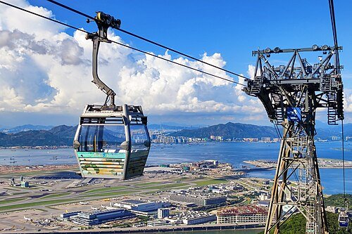 Ngong Ping 360 · 昂坪360
Ngong Ping 360 · Ngong Ping terminal昂坪360·昂坪端站
Ngong Ping 360 turns the ascent from Tung Chung into a view across water, airport infrastructure and the wooded hills of northern Lantau. The cable route crosses Tung Chung Bay, changes direction near Airport Island and climbs…
Read the place guide →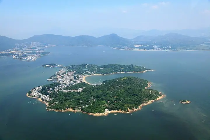 Aerial view of Peng Chau · 坪洲航拍全景 Photograph date recorded by the source: 21 August 2017.
Peng Chau坪洲
Peng Chau combines village-scale religious buildings with the reuse of its industrial spaces. At the former Fook Yuen Leather Factory, discarded chairs, bottles and tyres have become playful installations among painted walls…
Read the place guide → Main hall and courtyard of Po Lin Monastery. Photograph date recorded by the source: 31 December 2005 (explicitly stated in the Commons file description).
Po Lin Monastery宝莲禅寺
Po Lin Monastery stands on the Ngong Ping plateau of Lantau Island. Its main shrine contains three bronze Buddha images representing past, present and future, while the Hall of Bodhisattva Skanda introduces another part of the…
Read the place guide →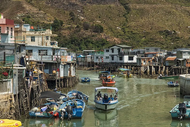 Stilt houses and boats along a Tai O waterway.
Tai O Fishing Village大澳
Tai O is a waterside settlement on western Lantau, where stilt houses line branches of the local river and creek. Pedestrian bridges join the two sides, making the water channels central to the village layout. Salted-fish and…
Read the place guide →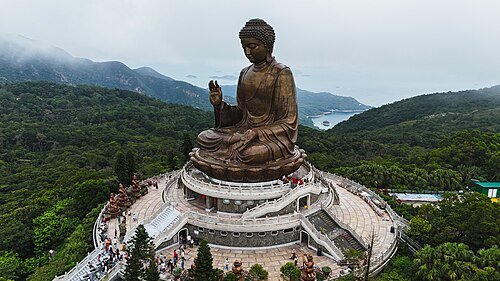 Tian Tan Buddha (Big Buddha) · 天坛大佛
Tian Tan Buddha天坛大佛
Tian Tan Buddha sits above Ngong Ping on Mount Muk Yue, with a broad lotus throne supporting the bronze figure. The raised right hand represents fearlessness, while the left rests palm-up in the lap. Looking from the approach…
Read the place guide →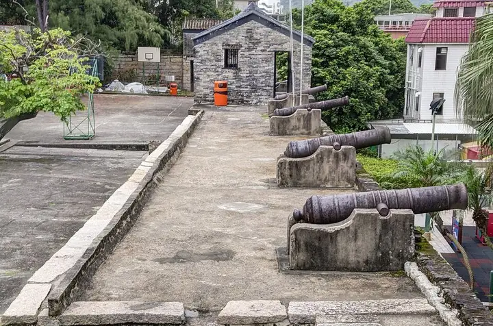 Wall-top cannon battery at Tung Chung Fort · 东涌炮台城墙炮位 Photograph date recorded by the source: 28 September 2013, 16:24:36.
Tung Chung Fort东涌炮台
Tung Chung Fort preserves a compact granite enclosure beside Sheung Ling Pei village. Chinese inscriptions mark its three arched gateways, and six old cannon stand along the north wall. The main entrance inscription supplies…
Read the place guide → AI illustration · AI 示意图(仅供参考,非该地点实拍)
Ngong Ping 360, Tian Tan Buddha and Po Lin Monastery昂坪360与天坛大佛宝莲禅寺
Ngong Ping is a highland visitor area on Lantau Island where the cable-car journey, Tian Tan Buddha and Po Lin Monastery can form one outing.
Read the place guide →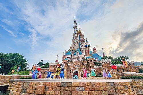 Hong Kong Disneyland · 香港迪士尼乐园
Hong Kong Disneyland香港迪士尼乐园
Hong Kong Disneyland combines elaborate ride settings with the Castle of Magical Dreams, whose design draws on thirteen Disney princess and queen stories. Frozen Ever After takes passengers by boat through Arendelle-inspired…
Read the place guide →Mui Wo and Silver Mine Bay viewed from the hillside on Lantau · 大屿山梅窝与银矿湾远景. Source-recorded photograph date: 2021-01-24 13:18:56.Mui Wo and Silvermine Bay梅窝与银矿湾
Mui Wo is a coastal town on eastern Lantau Island, with a ferry pier, neighbourhood food businesses and a promenade leading toward Silvermine Bay Beach.
Read the place guide →Local life & food
Islands District local specialties
離島特色美食 · 2 specialties to discover
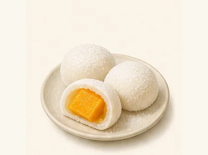 Cheung Chau mango mochi 長洲芒果糯米糍AI dish illustration / AI 菜品示意图
The wrapper is sticky and yielding against the juicy fruit centre. A large fruit piece gives a different experience from a mango-flavoured paste filling.
Source ↗Read the dish guide → Cheung Chau lucky buns 長洲平安包AI dish illustration / AI 菜品示意图
Expect fluffy dough and a sweeter, denser centre, rather than the crisp topping of a pineapple bun.
Source ↗Read the dish guide →All dish names · 全部菜名 (2)
More dishes from across Hong Kong are in the Hong Kong food guide.
Plan your visit
Getting there
Islands District is about 25 km in a straight line from central Hong Kong. Search for 離島 in a map app to find stations and your accommodation.
Where to stay →Build your route
Cheung Chau and Hong Kong International Airport are about 15 km apart in a straight line. The linked place guides have entrance and visit details.
Continue with Hong Kong →More in Hong Kong
Sources & geographic information
Administrative names and parent areas: Official geographic directory · Reference date 2026-09-06.
Photo: Cheung Chau · Man77 · Man77 — Blick_über_Cheung_Chau.JPG — CC BY-SA 3.0 · CC BY-SA 3.0. The exact downloaded source bytes are separately retained and hashed. Prepared JPEG is proportionally reduced to a maximum 720-pixel long edge; full frame retained, no subject alteration. Final website rendition: full frame retained, proportionally resized to at most 720 pixels and converted to WebP. No additional retouching or subject alteration. Card displays may crop the view.

Photo: Hong Kong International Airport · Dinkun Chen · Dinkun Chen — HONG_KONG_INTERNATIONAL_AIRPORT_(11).jpg — CC BY-SA 4.0 · CC BY-SA 4.0. The exact downloaded source bytes are separately retained and hashed. Prepared JPEG is proportionally reduced to a maximum 720-pixel long edge; full frame retained, no subject alteration. Final website rendition: full frame retained, proportionally resized to at most 720 pixels and converted to WebP. No additional retouching or subject alteration. Card displays may crop the view.
.jpg)
Photo: Lamma Island · Chensiyuan · Chensiyuan — Aerial_photo_of_Yung_Shue_Wan,_Lamma_Island.jpg — CC BY-SA 4.0 · CC BY-SA 4.0. The exact downloaded source bytes are separately retained and hashed. Prepared JPEG is proportionally reduced to a maximum 720-pixel long edge; full frame retained, no subject alteration. Final website rendition: full frame retained, proportionally resized to at most 720 pixels and converted to WebP. No additional retouching or subject alteration. Card displays may crop the view.

Photo: Mui Wo · FuriiToo · FuriiToo — Mui_Wo_2021.jpg — CC BY-SA 4.0 · CC BY-SA 4.0. The exact downloaded source bytes are separately retained and hashed. Prepared JPEG is proportionally reduced to a maximum 720-pixel long edge; full frame retained, no subject alteration. Final website rendition: full frame retained, proportionally resized to at most 720 pixels and converted to WebP. No additional retouching or subject alteration. Card displays may crop the view.

Photo: Ngong Ping 360 · Ngong Ping terminal · Sparktour · CC BY-SA 4.0. Wikimedia thumbnail; fitted to the ranking-card frame.

Photo: Peng Chau · Geographer · User:Geographer · CC BY-SA 4.0. The exact downloaded source bytes are separately retained and hashed. Prepared JPEG is proportionally reduced to a maximum 720-pixel long edge; full frame retained, no subject alteration. Final website rendition: full frame retained, proportionally resized to at most 720 pixels and converted to WebP. No additional retouching or subject alteration. Card displays may crop the view.

Photo: Po Lin Monastery · Enoch Lau (Enochlau) · CC BY-SA 3.0. Full frame retained; proportionally resized and converted to WebP. No retouching or changes to the photographed subject. Card displays may crop the view.

Photo: Tai O Fishing Village · chensiyuan · CC BY-SA 4.0. Full frame retained; proportionally resized and converted to WebP. No retouching or changes to the photographed subject. Card displays may crop the view.

Photo: Tian Tan Buddha · Huangdan2060 · CC BY 4.0. Wikimedia thumbnail; fitted to the ranking-card frame.

Photo: Tung Chung Fort · Kalatpadai · Kalatpadai — Canons_at_Tung_Chung_Fort_03.jpg — CC BY-SA 3.0 · CC BY-SA 3.0. The exact downloaded source bytes are separately retained and hashed. Prepared JPEG is proportionally reduced to a maximum 720-pixel long edge; full frame retained, no subject alteration. Final website rendition: full frame retained, proportionally resized to at most 720 pixels and converted to WebP. No additional retouching or subject alteration. Card displays may crop the view.

Photo: Hong Kong Disneyland · Ashwin Kumar · CC BY-SA 2.0. Wikimedia thumbnail; fitted to the ranking-card frame.

Photo: Mui Wo and Silvermine Bay · FuriiToo · CC BY-SA 4.0. Full source framing retained; proportionally resized and converted to WebP. No retouching or subject alteration. Card displays may crop the view.
Map data © OpenStreetMap contributors. Pins mark approximate centres, not entrances or boundaries.