


Get to know Horqin Left Middle Banner

- Administrative area
- Banner · 旗
- Part of
- Tongliao
- Chinese name
- 科尔沁左翼中旗
- Local areas
- Banner guide
Area & population
- Area in the source
- 9,590.00 km²
- Population · 2020
- 399,631
- Administrative seat
- Baokang Town
Source: cited geographic source, as of the dates shown.
Setting and landscape
The banner stretches 191 km east to west and 116 km north to south, and its average altitude is only 120 to 215 metres, a transition zone between the Songliao Plain and the Inner Mongolian Plateau. The Zhurihe open woodland grassland (珠日河疏林草原), 115 km north of Tongliao city, covers 50,000 mu of old elm groves and natural pasture; the banner government says 70 percent of the elms are more than a century old.
History
The banner was created in 1636, in the Chongde reign of the Qing, and was popularly known as the Darhan Banner (达尔罕旗) after the Darhan prince of the Horqin. In 1914 the Republican government founded Tongliao town at Balintailai (巴林太来), inside the banner. From 1932 to 1949 its official name was East Horqin Middle Banner (东科中旗). During the civil war the Eastern Mongolian Military and Political Cadre School (东蒙军政干部学校) was set up here, at Bayantala (巴彦塔拉). The banner government calls it the home of the Qing empress Xiaozhuang (孝庄文皇后) and of the Mongol hero Gada Meiren (嘎达梅林).
What to see
The Xiaozhuang Garden Cultural Tourism Area (孝庄园文化旅游区), a 4A scenic area of 8,000 mu, is themed on the empress's birthplace on the former site of the Darhan Prince's Mansion (达尔罕亲王府), 48 km from urban Tongliao.
The Hamin Archaeological Site Park (哈民考古遗址公园) in Sheboutu Town (舍伯吐镇) protects a settlement of 5,500 to 5,000 years ago. Excavators found 81 house sites; the timber frames of over ten semi-subterranean houses survive, and one house of only 18 square metres held 97 human skeletons. It was named one of the national top ten archaeological discoveries in 2011 and a national key cultural relics protection unit in 2019.
The Zhurihe Grassland Tourism Area (珠日河草原旅游区) hosts the Jirem horse-racing festival (哲里木赛马节) and offers horse racing, bökh wrestling (博克), archery and camel rides.
Food, music and local culture
The banner is the birthplace of the chor (潮尔) master Selaxi (色拉西), the sihu (四胡) fiddler Sun Liang (孙良) and the morin khuur player Chi Bulag (齐·宝力高). In 2010 a thousand-player sihu performance set a Guinness world record. Chinese Wikipedia lists the long narrative song Gada Meiren among the national intangible heritage items.
At Zhurihe visitors eat hand-torn mutton, roast whole lamb and milk tea. The banner government's food page describes chaomi (炒米), known in Mongolian as khuursen budaa (呼日森布达): broomcorn millet steamed, fried and milled, eaten at breakfast with butter, boiled mutton and salted milk tea.
Highlights
- Xiaozhuang Garden Cultural Tourism Area 孝庄园文化旅游区: 4A scenic area on the site of the Darhan Prince's Mansion, themed on Empress Xiaozhuang's birthplace.
- Hamin Archaeological Site Park 哈民考古遗址公园: Settlement of 5,500 to 5,000 years ago with surviving house timbers; national key cultural relics protection unit since 2019.
- Zhurihe Grassland Tourism Area 珠日河草原旅游区: Venue of the Jirem horse-racing festival, with wrestling, archery and camel rides.
- Zhurihe open woodland grassland 珠日河疏林草原: 50,000 mu of old elm groves and pasture, most elms over a century old.
- Chaomi 炒米: Steamed, fried and milled broomcorn millet eaten at breakfast with milk tea.
Sources for this guide
科左中旗概况 · Horqin Left Middle Banner People's Government
游在左中 · Horqin Left Middle Banner People's Government
食在左中 · Horqin Left Middle Banner People's Government
科尔沁左翼中旗 · Wikipedia (Chinese) · CC BY-SA 4.0
科左中旗旅游概况 · Horqin Left Middle Banner People's Government
Original English written from the listed sources and checked sentence by sentence against quoted extracts by a separate reviewer. Updated 2026-09-26.
Explore Horqin Left Middle Banner
Core places to explore, with English and Chinese names.
Places to explore around Horqin Left Middle Banner
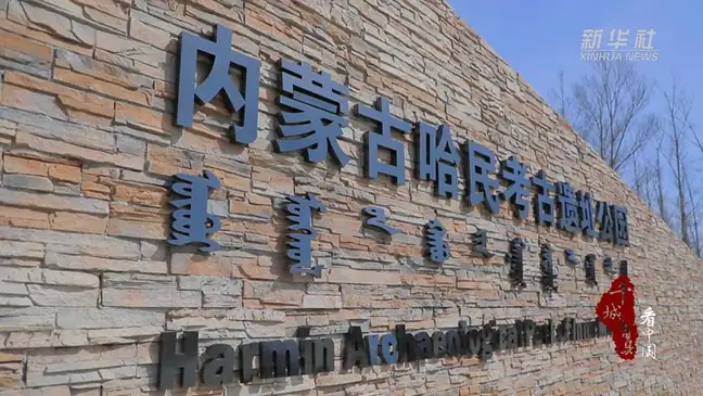 Hamin Archaeological Site · 哈民遗址
Hamin Archaeological Site哈民遗址
Hamin Archaeological Site (哈民遗址) is a late Neolithic settlement in Horqin Left Middle Banner, known for orderly rows of houses built partly below ground.
Read the place guide → AI illustration · AI 示意图(仅供参考,非该地点实拍)
Xiaozhuang Park孝庄园
Xiaozhuang Park (孝庄园) is a cultural complex in Horqin Left Middle Banner centred on a reconstructed Darhan princely palace and the history of Empress Dowager Xiaozhuang's Mongol family.
Read the place guide →Plan your visit
Getting there
Horqin Left Middle Banner is about 100 km in a straight line from central Tongliao. Search for 科尔沁左翼中旗 in a map app to find stations and your accommodation.
Where to stay →Build your route
Hamin Archaeological Site and Xiaozhuang Park are both listed here. The linked place guides have entrance and visit details.
Continue with Tongliao →More in Tongliao
Sources & geographic information
Administrative names and parent areas: Official geographic directory · Reference date 2026-09-06.
Some facts checked against 科尔沁左翼中旗 — Wikipedia contributors, CC BY-SA 4.0.
Photo: Hamin Archaeological Site · Source photographer · License not provided. EXIF orientation normalized; resized without changing aspect ratio; converted to WebP. No subject edits.
Map data © OpenStreetMap contributors. Pins mark approximate centres, not entrances or boundaries.