


Get to know Qinghemen District
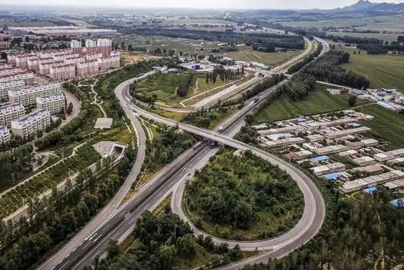
Photo adjustments
EXIF orientation normalized; resized without changing aspect ratio; converted to WebP. No subject edits.
- Administrative area
- District · 市辖区
- Part of
- Fuxin
- Chinese name
- 清河门区
- Local areas
- District guide
Area & population
- Area in the source
- 92.55 km²
- Population · 2020 census
- 51,394
Source: cited geographic source, as of the dates shown.
Setting and landscape
The district government describes the land as semi-hilly, with the Yiwulü Mountains (医巫闾山) in view to the east and Daqing Mountain (大青山) behind it to the west. The Xi River separates it from Shaohuyingzi (稍户营子镇) in Yi County (义县) on the east; Yi County also borders it to the west and south, and the Fuxin Mongol Autonomous County (阜新蒙古族自治县) to the north. The district covers 98.54 square kilometres.
History
In May 1960 the Qinghemen and Laoyemiao (老爷庙) management areas of Yi County were transferred to Fuxin's suburban district, and Fuxin created Qinghemen District in March 1984. According to the Liaoning Daily, at the height of mining four large mines of the Fuxin Mining Group and more than 40 local mines worked an area of about 100 square kilometres, and a century of extraction left subsidence across two-thirds of the district. The last mines closed in 2018. A leather industry park begun in Hexi (河西镇) in 2009 grew into one of the district's three economic sectors, alongside new materials and new energy.
What to see
Huanghua Mountain (黄花山) at Zhujiatun (朱家屯) in Wulongba (乌龙坝镇) was a strategic point in the past; the Tangtou River (汤头河) winds in front of it, and remains of the Ming Great Wall and the Willow Palisade (柳条边) lie nearby. A cooperative set up by Wulongba has planted 66 hectares of daylilies below the hill. Since 2018 Wulongba has held a Bianmen ("border gate") folk-customs festival. Fuxin's tourism bureau lists Xingjiatun (邢家屯村) in Hexi as a provincial key village for rural tourism, and it places geothermal resources along a belt from Qinghemen in the west to Xinqiu (新邱区) in the east.
Food and local products
Hexi's farm produce is known across western Liaoning: fruit from Xingjiatun, Chinese chives from Sandaohao (三道壕), green-fleshed cucumbers from Houyao (后窑) and fruit tomatoes from Liutai (六台). Xingjiatun also holds a fruit-picking festival.
Highlights
- Huanghua Mountain 黄花山: Former strategic point at Zhujiatun, with Ming Great Wall and Willow Palisade remains nearby and daylily fields below.
- Xingjiatun Village 邢家屯村: Listed by Fuxin's tourism bureau as a provincial key village for rural tourism; known for fruit and a picking festival.
- Houyao green-fleshed cucumber 后窑的绿瓤黄瓜: One of the Hexi farm products the Liaoning Daily names as known across western Liaoning.
Sources for this guide
清河门区 - 维基百科,自由的百科全书 · Chinese Wikipedia · CC BY-SA 4.0
走进清河门 · Qinghemen District People's Government
挥别百年采煤史 探索创新转型路 · Liaoning Daily (republished by the Liaoning Provincial People's Government portal)
阜新·历史沿革 · Fuxin Municipal People's Government
阜新市旅游资源简介 · Fuxin Municipal Bureau of Culture, Tourism, Radio and Television
Original English written from the listed sources and checked sentence by sentence against quoted extracts by a separate reviewer. Updated 2026-09-26.
Explore Qinghemen District
Core places to explore, with English and Chinese names.
Qinghemen District 清河门区
Plan your visit
Getting there
Qinghemen District is about 35 km in a straight line from central Fuxin. Search for 清河门区 in a map app to find stations and your accommodation.
Where to stay →More in Fuxin
Sources & geographic information
Administrative names and parent areas: Official geographic directory · Reference date 2026-09-06.
Some facts checked against 清河门区 — Wikipedia contributors, CC BY-SA 4.0.
Map data © OpenStreetMap contributors. Pins mark approximate centres, not entrances or boundaries.