


Get to know Hanbin District

Photo adjustments
Full frame retained; proportionally resized and converted to WebP. No retouching or changes to the photographed subject. Card displays may crop the view.
- Administrative area
- District · 市辖区
- Part of
- Ankang
- Chinese name
- 汉滨区
- Local areas
- District guide
Area & population
- Area in the source
- 3,646.00 km²
- Population · 2018
- 1,020,000
Source: cited geographic source, as of the dates shown.
Setting and landscape
The district government sums up the terrain as "two mountains holding one valley". The eastern end of Phoenix Mountain (凤凰山) stands between the Han and the Yue River (月河); north of the Yue the land belongs to the Qinling uplands, south of it to outliers of the Daba range. The ground is high to the north and south and low in the middle, with wide valley basins and low and middle mountains from 210 to 2,141 metres. The Han runs for 110 kilometres through the district, which the government counts as an important water-conservation area for the middle route of the South–North Water Transfer Project.
Neighbours are Xunyang (旬阳) to the east, Pingli (平利) and Langao (岚皋) to the south, Hanyin (汉阴) and Ziyang (紫阳) to the west, and Ningshan (宁陕) and Zhen'an (镇安) to the north.
History
Xicheng County (西城县) was first set up here under King Huiwen of Qin (秦惠文王). The Western Wei called the area Jinzhou (金州), "gold prefecture", for the gold it produced. In 1583 a flood drowned the prefectural town; a new town was built to its south below Zhaotai Mountain (赵台山), and Jinzhou was renamed Xing'an Prefecture (兴安州). The name Ankang, "peace and health", goes back to 280, when a county of that name was set up in present-day Shiquan (石泉) and Hanyin for refugees from the Daba Mountains. The area became Ankang County in 1783, a county-level city in 1988 and Hanbin District in 2000.
According to the district government, most of its people were historically late Ming and early Qing migrants from Huguang (湖广). Handiao Erhuang (汉调二黄), the opera form that represents Ankang's local culture, has been performed here for more than 400 years.
What to see
The district lists three national 4A scenic areas: Yinghu Lake (瀛湖), Shuanglong (双龙) eco-tourism resort and the Qinba (秦巴) cultural eco-tourism area. Its 3A sites include the Ankang Museum (安康博物馆), the Ancient Xicheng cultural park (古西城文化园) and Xiangxi Cave (香溪洞). Yinghu Lake is the reservoir of the Ankang hydropower dam at Huoshiyan (火石岩乡): a long, gorge-type lake of 77.5 square kilometres on the Han behind a 125-metre concrete gravity dam, built between 1982 and 1992.
Food and local products
The district government says all its land contains organic selenium, and it has production bases for selenium-rich pork, tea, walnuts, vegetables and konjac. Hanbin grapes (汉滨葡萄) have been entered in the national list of distinctive quality farm products; the district describes even-sized, sweet-fleshed berries.
Highlights
- Yinghu Lake 瀛湖: Reservoir of the Ankang hydropower dam on the Han, 77.5 km², behind a 125 m dam finished in 1992; a national 4A scenic area.
- Ankang Museum 安康博物馆: Listed by the district as a national 3A scenic site.
- Xiangxi Cave 香溪洞: One of the four national 3A scenic sites in the district.
- Handiao Erhuang opera 汉调二黄: Ankang's representative opera form, performed in Hanbin for more than 400 years.
- Hanbin grapes 汉滨葡萄: On the national list of distinctive quality farm products.
Sources for this guide
汉滨概况-汉滨区人民政府 · Hanbin District People's Government, Ankang
历史沿革-汉滨区人民政府 · Hanbin District People's Government, Ankang
物产资源-汉滨区人民政府 · Hanbin District People's Government, Ankang
安康水库 - 维基百科,自由的百科全书 · Chinese Wikipedia · CC BY-SA 4.0
Original English written from the listed sources and checked sentence by sentence against quoted extracts by a separate reviewer. Updated 2026-09-26.
Explore Hanbin District
Core places to explore, with English and Chinese names.
Places to explore around Hanbin District
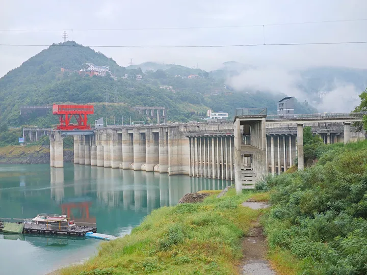 The Ankang Dam impounding Yinghu Lake on the Han River, Hanbin District, Ankang ·
 Plan your visit
Getting there
Hanbin District covers the centre of Ankang. Search for 汉滨区 in a map app to find stations and your accommodation.
Where to stay →Build your route
Start with Yinghu Lake. The linked place guides have entrance and visit details.
Continue with Ankang →More in Ankang
Sources & geographic information
Administrative names and parent areas: Official geographic directory · Reference date 2026-09-06.
Some facts checked against 安康水库 — Wikipedia contributors, CC BY-SA 4.0.
Photo: Yinghu Lake · Liuxingy · CC BY-SA 4.0. Full frame retained; proportionally resized and converted to WebP. No retouching or changes to the photographed subject. Card displays may crop the view.

Map data © OpenStreetMap contributors. Pins mark approximate centres, not entrances or boundaries.