


Get to know Jintai District
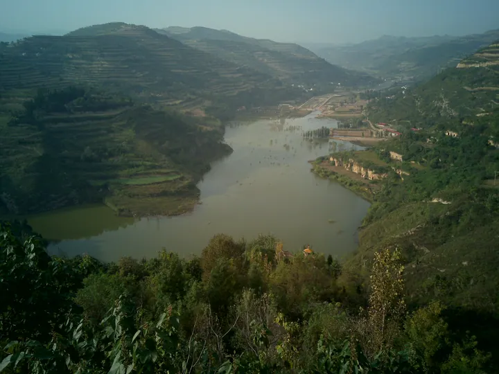
Photo adjustments
Full frame retained; proportionally resized and converted to WebP. No retouching or changes to the photographed subject. Card displays may crop the view.
- Administrative area
- District · 市辖区
- Part of
- Baoji
- Chinese name
- 金台区
- Local areas
- District guide
Area & population
- Area in the source
- 52.16 km²
- Population · 2019
- 398,300
Source: cited geographic source, as of the dates shown.
Setting and landscape
Of the district's 309 square kilometres, the district government counts 45 as plain, 60 as loess tableland (塬) and 204 as mountains, so most of Jintai is tableland and mountain rather than plain. The government describes the area as a historic chokepoint on the routes north from Sichuan and from Gansu and Ningxia into the Guanzhong basin.
What to see
Jintai Temple stands on a terrace in the north of the city, about half a kilometre north of the railway station. It dates from the late Yuan or early Ming, and is known as a place where Zhang Sanfeng (张三丰), founder of the Wudang school, practised Daoism. Its buildings follow a central axis up the slope and include the two-storey Jade Emperor Pavilion (玉皇阁), the Hall of the Three Pure Ones (三清大殿), an octagonal pavilion and the Sanfeng Cave (三丰洞); Chinese Wikipedia notes that the Hall of the Three Pure Ones has been turned into the Jintai Academy (金台书院) since 2020.
The district has three national protected sites: the Neolithic Beishouling site (北首岭遗址), Jintai Temple, listed for its Ming to Qing buildings, and the former Baoji Shenxin cotton mill (宝鸡申新纱厂旧址) of 1941 to 1943. The district government also names the Chenbao Shrine (陈宝祠), a place of state sacrifice under the Qin and Han, and Wolong Temple (卧龙寺), where Emperor Xuanzong of Tang stayed on his way into Sichuan. It also lists the tomb of Li Maozhen (李茂贞) and his wife, known as the Tang Prince of Qin's Tomb (大唐秦王陵), and the Changleyuan wartime industrial site (长乐塬抗战工业遗址). Newer attractions it lists include Xifu Old Street (西府老街).
Getting oriented
The Longhai railway, the Xi'an to Lanzhou high-speed line, the Lianyungang to Khorgas expressway and National Highway 310 cross the district from east to west. The Baoji to Zhongwei and Baoji to Chengdu railways and the Baoji to Hanzhong expressway run through it from north to south. The district government sits on Zhongshan East Road (中山东路).
Highlights
- Jintai Temple 金台观: Late Yuan or early Ming Daoist complex linked with Zhang Sanfeng; a national protected site for its Ming to Qing buildings.
- Beishouling site 北首岭遗址: Neolithic settlement site of the Yangshao period, listed nationally.
- Former Baoji Shenxin cotton mill 宝鸡申新纱厂旧址: Wartime mill of 1941 to 1943, listed as a national protected site.
- Wolong Temple 卧龙寺: Where Emperor Xuanzong of Tang stayed on his way into Sichuan, according to the district government.
Sources for this guide
金台概况 宝鸡市金台区人民政府 · Jintai District People's Government, Baoji
长乐塬抗战工业遗址 宝鸡市金台区人民政府 · Jintai District People's Government, Baoji
金台区 - 维基百科 · Wikipedia (Chinese) · CC BY-SA 4.0
金台区各级文物保护单位列表 - 维基百科 · Wikipedia (Chinese) · CC BY-SA 4.0
金台观 - 维基百科 · Wikipedia (Chinese) · CC BY-SA 4.0
Original English written from the listed sources and checked sentence by sentence against quoted extracts by a separate reviewer. Updated 2026-09-26.
Explore Jintai District
Core places to explore, with English and Chinese names.
Jintai District 金台区
Plan your visit
Getting there
Jintai District is about 8 km in a straight line from central Baoji. Search for 金台区 in a map app to find stations and your accommodation.
Where to stay →More in Baoji
Sources & geographic information
Administrative names and parent areas: Official geographic directory (dmfw.mca.gov.cn) · Reference date 2026-09-06.
Some facts checked against 金台区 — Wikipedia contributors, CC BY-SA 4.0.
Some facts checked against 金台区各级文物保护单位列表 — Wikipedia contributors, CC BY-SA 4.0.
Some facts checked against 金台观 — Wikipedia contributors, CC BY-SA 4.0.
Map data © OpenStreetMap contributors. Pins mark approximate centres, not entrances or boundaries.