


Get to know Yingxian
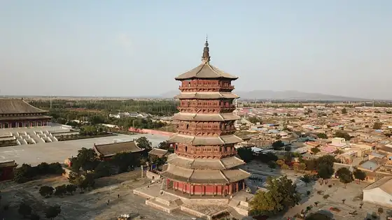
Photo adjustments
Resized and WebP compressed; subject not altered.
- Administrative area
- County · 县
- Part of
- Shuozhou
- Chinese name
- 应县
- Local areas
- County guide
Area & population
- Area in the source
- 1,688.00 km²
- Population · 2020
- 243,970
Source: cited geographic source, as of the dates shown.
Reading the wooden structure
The pagoda rises 67.31 metres on an octagonal plan. From outside it appears to have five storeys and six sets of eaves, but four hidden levels bring the internal total to nine. Deeply projecting double eaves mark the lowest storey. More than fifty varieties of bracket sets articulate the structure, and each visible storey has a Buddha image at its centre.
Images, texts and architectural study
The pagoda’s associated works include Buddhist images, painted murals, plaques, paired inscriptions and stone inscriptions. Discoveries inside during the later twentieth century included Buddhist scriptures and the Herb-gathering Picture (采药图), both among its Liao-period relics. Architectural researchers Liang Sicheng (梁思成) and Mo Zongjiang (莫宗江) first surveyed and measured the tower in 1933.
Sources for this guide
山西团代表建议:启动1∶1研究性复建应县木塔 · Science and Technology Daily
别让“病歪歪”的应县木塔在议而不决中倒掉-新华网 · Xinhua Daily Telegraph
Original English written from the listed sources and checked sentence by sentence against quoted extracts by a separate reviewer. Updated 2026-09-26.
Explore Yingxian
Core places to explore, with English and Chinese names.
Places to explore around Yingxian
Plan your visit
Getting there
Yingxian is about 70 km in a straight line from central Shuozhou. Search for 应县 in a map app to find stations and your accommodation.
Where to stay →Build your route
Start with Pagoda of Fogong Temple. The linked place guides have entrance and visit details.
Continue with Shuozhou →More in Shuozhou
Sources & geographic information
Administrative names and parent areas: Official geographic directory · Reference date 2026-09-06.
Photo: Pagoda of Fogong Temple · Charlie fong · CC BY-SA 4.0. Resized and WebP compressed; subject not altered.

Map data © OpenStreetMap contributors. Pins mark approximate centres, not entrances or boundaries.