


Get to know Liuqiu Township
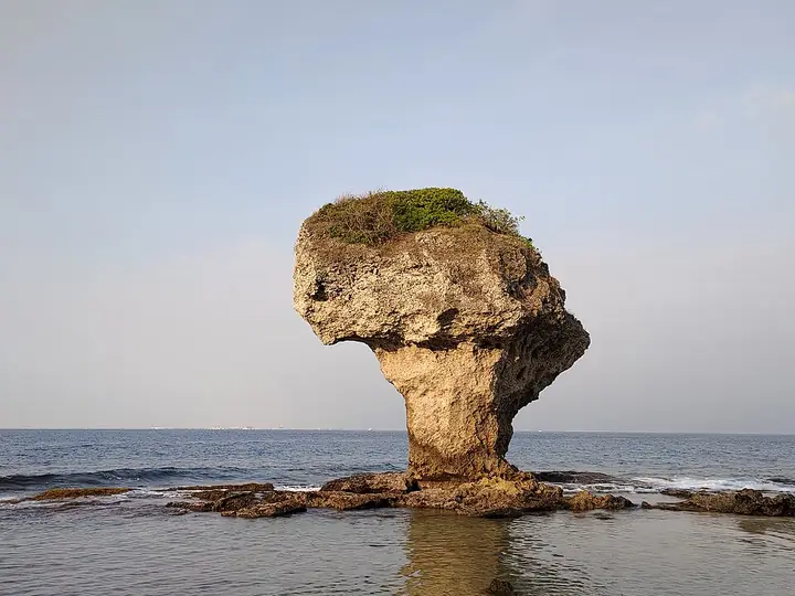
Photo adjustments
Full-frame source proportionally resized and converted to WebP for display. No subject alteration. Source-supplied marks and edits remain; cards may crop the view.
- Administrative area
- Rural township · 鄉
- Part of
- Pingtung County
- Chinese name
- 琉球鄉
- Local areas
- Rural township guide
Reef life
Green sea turtles inhabit the waters around the island, including those near Vase Rock (花瓶岩) and Beauty Cave (美人洞). Snorkelling and diving are ways to encounter this marine environment. Guided intertidal walks take visitors onto reef flats after the tide recedes, where sea urchins, sea cucumbers, sea hares and brittle stars can be observed.
Coastal paths and harbour views
Beauty Cave has paths between hillside and sea, while Shanzhugou (山豬溝) is wooded and Wugui Cave (烏鬼洞) offers rock passages and sea views. Beside Baisha Tourist Harbour (白沙觀光港), the visitor centre stands on a slope. Its outdoor viewing platform overlooks the harbour and surrounding sea.
Sources for this guide
自然與戶外-大鵬灣全球資訊網 · Dapeng Bay National Scenic Area Headquarters
小琉球遊客中心-大鵬灣全球資訊網 · Dapeng Bay National Scenic Area Headquarters
Original English written from the listed sources and checked sentence by sentence against quoted extracts by a separate reviewer. Updated 2026-09-27.
Explore Liuqiu Township
Core places to explore, with English and Chinese names.
Places to explore around Liuqiu Township
Plan your visit
Getting there
Liuqiu Township is about 40 km in a straight line from central Pingtung County. Search for 琉球鄉 in a map app to find stations and your accommodation.
Where to stay →Build your route
Start with Liuqiu Island. The linked place guides have entrance and visit details.
Continue with Pingtung County →More in Pingtung County
Sources & geographic information
Administrative names and parent areas: Official geographic directory · Reference date 2026-09-06.
Photo: Liuqiu Island · Koala0090 · CC BY-SA 4.0. Full-frame source proportionally resized and converted to WebP for display. No subject alteration. Source-supplied marks and edits remain; cards may crop the view.

Map data © OpenStreetMap contributors. Pins mark approximate centres, not entrances or boundaries.