


Get to know Heping District
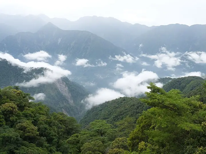
Photo adjustments
Full-frame source proportionally resized and converted to WebP for display. No subject alteration. Source-supplied marks and edits remain; cards may crop the view.
- Administrative area
- District · 區
- Part of
- Taichung City
- Chinese name
- 和平區
- Local areas
- District guide
Setting and landscape
The district office describes Heping as walled in on three sides: Nanhu Mountain (南湖山) on the Central Range to the east, the Xueshan Range to the north, and Hehuan Mountain (合歡山) and Dayuling (大禹嶺) to the south, with the Dajia River running through the middle. The district lies at altitudes of 1,000 to 3,000 metres, and the office gives an average annual temperature of about 18°C, which makes it a summer retreat. The Formosan landlocked salmon (櫻花鉤吻鮭) lives in Qijiawan Creek (七家灣溪) at Wuling Farm.
History
The land was Atayal territory. Under Japanese rule it was administered as a police-run aboriginal area of Dongshi (東勢) county; after repeated resistance the authorities divided it into three police districts and forced villages to move. After 1945 it became part of Taichung County and was given the name Heping, meaning "peace". Nanshi (南勢), on the south bank of the Dajia River, is entirely Hakka, and veterans who came from mainland China live at Pingdeng (平等) and Lishan (梨山).
What to see
The district office names Guguan (谷關) hot springs, the Lishan scenic area, Wuling Farm (武陵農場), Fushoushan Farm (福壽山農場), Tianchi (天池), Daxueshan (大雪山), the Baxianshan (八仙山) forest recreation area and the Central Cross-Island Highway (中橫公路) as its main attractions. Guguan, called the first pass on the cross-island highway, sits beside the Dajia River gorge and has weakly alkaline carbonate springs. Shei-Pa National Park (雪霸國家公園) and the Wuling, Daxueshan and Baxianshan national forest recreation areas are also among the places to visit in the district. Atayal culture and weaving are kept alive in villages such as Huanshan (環山) in Pingdeng.
Food and local products
Farming here is high-mountain fruit and vegetables: sweet persimmons, tangerines, pears, apples, peaches and plums, along with Lishan cabbage and bamboo shoots. The office also lists trout, river shrimp and honey among local specialities, and Wikipedia describes Heping as a main source of Taiwan's high-altitude vegetables, with high-mountain tea grown in the east.
Highlights
- Wuling Farm 武陵農場: Its Qijiawan Creek is home to the Formosan landlocked salmon.
- Guguan hot springs 谷關溫泉: Weakly alkaline carbonate springs beside the Dajia River gorge.
- Daxueshan National Forest Recreation Area 大雪山國家森林遊樂區: One of three national forest recreation areas in the district.
- Lishan 梨山: A scenic area named by the district office; veterans from the mainland live there.
- Lishan cabbage 梨山高麗菜: One of the high-mountain vegetables listed among Heping's specialities.
Sources for this guide
臺中市和平區公所-歷史沿革-歷史沿革 · Heping District Office, Taichung City Government
臺中市和平區公所-地理環境-地理環境 · Heping District Office, Taichung City Government
臺中市和平區公所-地方特產-地方特產 · Heping District Office, Taichung City Government
和平区 (台湾) - 维基百科,自由的百科全书 · Wikipedia (Chinese) · CC BY-SA 4.0
Original English written from the listed sources and checked sentence by sentence against quoted extracts by a separate reviewer. Updated 2026-09-25.
Explore Heping District
Core places to explore, with English and Chinese names.
Places to explore around Heping District
Daxueshan National Forest Recreation Area in Taichung · 台中大雪山国家森林游乐区 Source-recorded photograph date: Taken on 8 July 2015.Daxueshan National Forest Recreation Area大雪山森林游乐区
Daxueshan National Forest Recreation Area occupies high forested terrain above the Dongshi side of Taichung.
Read the place guide →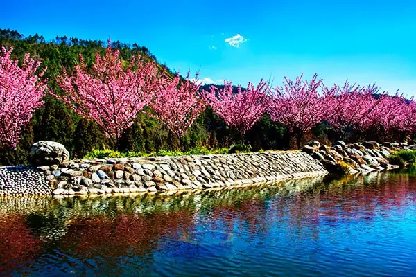 Cherry blossoms at Wuling Farm in Heping, Taichung · 台中和平区武陵农场樱花 Source-recorded photograph date: 2013-12-14 03:12:05.
Wuling Farm武陵农场
Wuling Farm lies in the Qijiawan Creek valley in Taichung's Heping District, within a high mountain landscape far from the urban centre.
Read the place guide →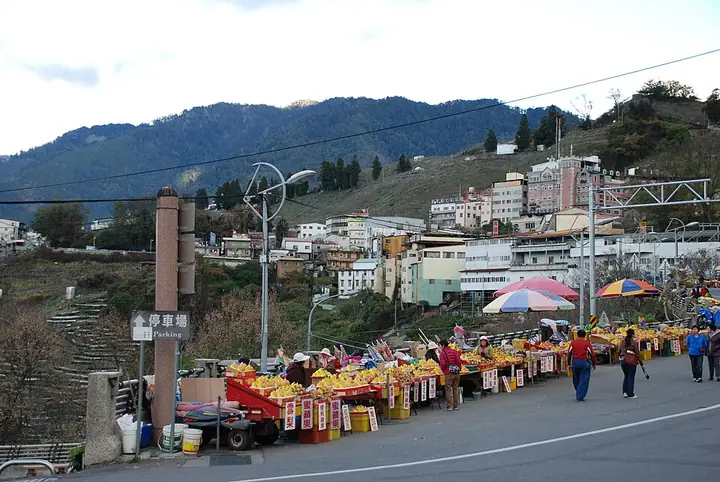 View of Lishan town in the mountains of Taichung · 台中山区梨山聚落景观 Source-recorded photograph date: 2012-12-29 17:05:23.
Lishan Mountain Settlement梨山
Lishan is a mountain settlement in Taichung's Heping District, associated with Atayal communities, temperate fruit growing and the history of the Central Cross-Island Highway.
Read the place guide →Plan your visit
Getting there
Heping District is about 50 km in a straight line from central Taichung City. Search for 和平區 in a map app to find stations and your accommodation.
Where to stay →Build your route
Daxueshan National Forest Recreation Area and Wuling Farm are both listed here. The linked place guides have entrance and visit details.
Continue with Taichung City →More in Taichung City
Sources & geographic information
Administrative names and parent areas: Official geographic directory · Reference date 2026-09-06.
Some facts checked against 和平区 (台湾) — Wikipedia contributors, CC BY-SA 4.0.
Photo: Daxueshan National Forest Recreation Area · lienyuan lee · CC BY 3.0. Full-frame source proportionally resized and converted to WebP for display. No subject alteration. Source-supplied marks and edits remain; cards may crop the view.
.jpg)
Photo: Wuling Farm · 葉瑞聰 (YEH Jui-tsung) · CC BY-SA 2.0. Full-frame source proportionally resized and converted to WebP for display. No subject alteration. Source-supplied marks and edits remain; cards may crop the view.

Photo: Lishan Mountain Settlement · 女王Evian Tsai · CC BY-SA 2.0. Full-frame source proportionally resized and converted to WebP for display. No subject alteration. Source-supplied marks and edits remain; cards may crop the view.

Map data © OpenStreetMap contributors. Pins mark approximate centres, not entrances or boundaries.